
501-918-3025
calsfoundation@cals.org
calsfoundation@cals.org
U.S. Highway 70 runs from southwestern Arkansas through Hot Springs (Garland County) and Little Rock (Pulaski County) to West Memphis (Crittenden County). It passes through thirteen counties in Arkansas. Until the completion of Interstate 40, it was the main highway linking Little Rock to Memphis, Tennessee, and it continues to be the principal route bringing travelers to Hot Springs.
Route
U.S. Highway 70 begins in Globe, Arizona—originally a mining settlement—and runs east 2,385 miles to Atlantic, North Carolina—an unincorporated community on the East Coast. About 280 of those highway miles are in Arkansas.
The highway enters Arkansas about eight miles west of De Queen (Sevier County), where it is called the Collin Raye Highway. In De Queen, it runs through the northern part of town as Collin Raye Drive, while the older highway—now Business 70—is first Locke Avenue and later Stillwell Avenue. Still in De Queen, Highway 70 joins with Highways 59 and 71, heading east across the Cossatot River, after which the highways diverge. Highway 70 strikes northeast to Dierks (Howard County), where it joins Highway 278, running a few miles north until the highways separate, with Highway 70 continuing northeast to Lake Greeson. The highway then moves eastward on the northern shore of the lake, passing through Daisy (Pike County) and arriving at Kirby (Pike County). In Kirby, the highway joins state Highways 27 and 84 and proceeds north to Glenwood (Pike County), having separated from state Highway 84 in Salem (Pike County).
In Glenwood, the highway crosses the Caddo River, separates from State Highway 27, veers south of downtown, and proceeds northeast toward Hot Springs. Highway 70 crosses the southeastern corner of Montgomery County and the northwestern corner of Hot Spring County before entering Garland County. The highway proceeds across the far southern part of the Ouachita National Forest, encountering Bonnerdale (Hot Spring County), Mount Moriah (Hot Spring County), Pearcy (Garland County), and Hempwallace (Garland County). Continuing to the north of the Lake Hamilton schools, it meanders through Pleasant Hill (Garland County) and Rockwell (Garland County), and across the Ouachita River, at which point it enters Hot Springs.
It joins U.S. Highway 270 near Memorial Field Airport to bypass Hot Springs to the south, while the original route, now Business 70, crosses the city as Airport Road, Albert Pike Road, and Grand Avenue. East of Hot Springs, the highway continues through forested hills until it meets Interstate 30 southwest of Benton (Saline County). U.S. Highway 70 remains mostly concurrent with the interstate through Benton, Bryant (Saline County), Alexander (Pulaski and Saline counties), and Little Rock. (Prior to the construction of the interstate, Highway 70 traversed Little Rock from south to north, becoming Broadway Avenue and crossing the Arkansas River on the Broadway Bridge.) Immediately after crossing the Arkansas River into North Little Rock (Pulaski County), Highway 70 leaves the interstate, becoming East Broadway Street. Running parallel to the river, the highway continues east, running on the northern shore of Hills Lake near Galloway (Pulaski County). Still proceeding eastward between Interstate 40 and the Arkansas River, Highway 70 encounters Lonoke (Lonoke County), where it is called Front street; Carlisle (Lonoke County), there identified as Park Street; Hazen (Prairie County), where it is South Front Street; and DeValls Bluff (Prairie County).
After crossing the White River, Highway 70 crosses Biscoe (Prairie County) and then passes through the Cache River National Wildlife Refuge. The highway traverses Brinkley (Monroe County), joining U.S. Highway 49 for a few blocks as Main Street before heading west as Cypress Street. The highway then runs to and through Wheatley (St. Francis County). From here, Highway 70 is visible from the interstate, just to the south. It continues through Blossom (St. Francis County), Goodwin (St. Francis County), Palestine (St. Francis County), and Redfern (St. Francis County)—all depots on the former Rock Island Railroad—before arriving at the county seat of Forrest City (St. Francis County).
In Forrest City, the highway is called Broadway Avenue. East of Forrest City, Highway 70 proceeds through Madison (St. Francis County) and crosses the St. Francis River. Hugging the interstate even more tightly, Highway 70 runs through Shearerville (St. Francis and Crittenden counties) and continues into West Memphis (Crittenden County). There, it links up with Interstate 55 to cross the Mississippi River.
History
The Arkansas River Valley was a transportation corridor long before the establishment of West Memphis (originally Hopefield) and North Little Rock (originally Argenta). Likewise, the route south of Little Rock that Highway 70 shares with Interstate 30 is a natural line of travel that was first improved as the Southwest Trail. The approach to Hot Springs is one of the few possible routes from the east.
With the rise of automobile traffic in the twentieth century, governments began to pay more attention to the improvement and maintenance of highways. The Arkansas General Assembly passed Act 302 in 1913, creating a Highway Commission to oversee road construction and maintenance. In 1925, the federal government established a system of national highways that included nine routes that cross Arkansas—Highway 70 being one of those nine. Highway 70 was intended to stretch from North Carolina to California and was known for a time as the Robert E. Lee Highway. Works Progress Administration (WPA) crews performed much highway improvement during the 1930s.
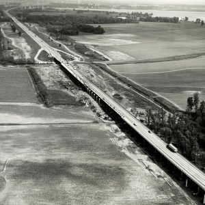
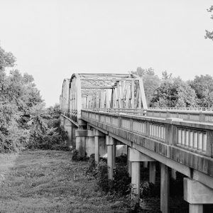
The original intention of the federal highway system was to connect cities and towns. With the advent of the interstate system in the 1950s, roads were built to bypass smaller towns while connecting large cities. The bypass of De Queen and Hot Springs reflects that newer priority. A four-mile stretch of highway in Lonoke County called the Union Valley Segment, built around 1913 but added to the federal highway system in 1925, was placed on the National Register of Historic Places on September 23, 2004.
In 2017, Highway 70 between Hot Springs and Interstate 30 began an expansion to five lanes. Previously, it had been a two-lane highway with several stretches of a third passing lane.
For additional information:
Historical Review, Volume Two: Arkansas State Highway Commission and Arkansas State Highway and Transportation Department, 1913–2003. Little Rock: Arkansas State Highway and Transportation Department, 2004.
“Old U.S. Highway 70, Union Valley Segment.” National Register of Historic Places nomination form. On file at Arkansas Historic Preservation Program, Little Rock, Arkansas. Online at https://www.arkansasheritage.com/arkansas-historic-preservation-program (accessed January 9, 2023).
Rhodes, Sonny. “Highway of Dreams.” Arkansas Democrat-Gazette, January 9, 2023, pp. 1D, 6D. Online at https://www.arkansasonline.com/news/2023/jan/09/motoring-into-the-past-on-good-old-us-70-arkansas/ (accessed January 9, 2023).
Simpson, Stephen. “Scenic U.S. 70 a Deadly Stretch.” Arkansas Democrat-Gazette, May 5, 2019, pp. 1A, 9A.
Steven Teske
Butler Center for Arkansas Studies


In the early 2020s, Highway 70 left University in Little Rock to leave I-30 on I-430 north to Stagecoach, then north to Colonel Glenn. It rejoins the existing 70 at the intersection of Colonel Glenn and University.