
501-918-3025
calsfoundation@cals.org
calsfoundation@cals.org
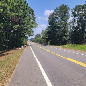
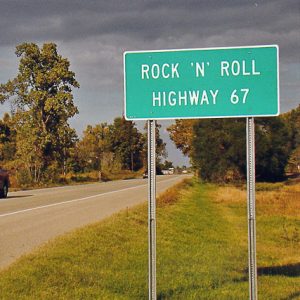
U.S. Highway 67 stretches from the southwestern corner of Arkansas in Texarkana (Miller County) to the northeastern corner of the state north of Corning (Clay County). It passes through thirteen counties, generally following the course of the military road known as the Southwest Trail, which was established across Arkansas during territorial times. In 2009, the Arkansas General Assembly designated a portion of the road as the Rock ’n’ Roll Highway—a reference to the musical heritage of the road. In 2024, a 100-plus-mile section of U.S. Highway 67 from North Little Rock (Pulaski County) to Walnut Ridge (Lawrence County) was re-designated Interstate 57, making it part of a larger interstate highway originally stretching from Chicago, Illinois, to Sikeston, Missouri.
Route
U.S. Highway 67 extends 1,560 miles, beginning in Presidio, Texas, at the border with Mexico, and ending near Sabula, Iowa. The Arkansas portion of the highway is roughly 280 miles.
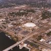
The highway enters Arkansas in the city of Texarkana as a divided highway locally designated as 7th Street and 8th Street. Briefly concurrent with U.S. Highway 82 in Texarkana, Highway 67 splits from Highway 82, angles to the northeast, and passes under Interstate 49, with ramps connecting to the interstate. From Texarkana, Highway 67 proceeds toward Little Rock (Pulaski County) in a route similar to that of Interstate 30; but while the interstate bypasses the cities and towns of southwestern Arkansas, Highway 67 runs through those communities, effectively connecting them. The highway goes through Fulton (Hempstead County), Hope (Hempstead County), Perrytown (Hempstead County), Emmet (Nevada and Hempstead counties), Prescott (Nevada County), Gurdon (Clark County), Gum Springs (Clark County), Arkadelphia (Clark County), Caddo Valley (Clark County), Midway (Hot Spring County), Donaldson (Hot Spring County), Malvern (Hot Spring County), and Haskell (Saline County) before entering the south side of Benton (Saline County).
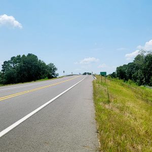
In Benton, Highway 67 again joins with Interstate 30, passing through Bryant (Saline County) and Alexander (Pulaski and Saline counties) before breaking away from the interstate in Mabelvale (Pulaski County). At this point, it becomes South University Avenue in Little Rock, proceeding north to the campus of the University of Arkansas at Little Rock (UALR), where the highway leaves University Avenue, running along Asher Avenue until it meets Broadway Avenue, which goes north to the Arkansas River. Crossing the river on the Broadway Bridge, the highway next joins with Broadway Avenue of North Little Rock, which is also U.S. Highway 70. Near the Simmons Bank Arena, Highway 67 merges again onto Interstate 30, joining U.S. Highway 167, and the two leave the interstate in North Little Rock and travel together through Sherwood (Pulaski County), Jacksonville (Pulaski County), Cabot (Lonoke County), Beebe (White County), and Searcy (White County), until the two highways diverge near Bald Knob (White County). The combined highways from North Little Rock to Bald Knob operate as a divided four-lane highway.
Highway 67 continues traveling northeast from Bald Knob, still a divided four-lane highway, bypassing Newport (Jackson County) and Tuckerman (Jackson County). Traveling around Swifton (Jackson County), Alicia (Lawrence County), and Minturn (Lawrence County), Highway 67 then joins with U.S. Highway 63 to bypass the cities of Hoxie (Lawrence County) and Walnut Ridge. At this point, the highway narrows to two lanes.
Leaving Highway 63, the highway heads north to Pocahontas (Randolph County), where it joins U.S. Highway 62. Together the highways pass near the old railroad towns of Biggers (Randolph County), Reyno (Randolph County), and Datto (Clay County), arriving at Corning, where the highways split. Highway 67 runs north out of Corning and into Missouri. An Arkansas Welcome Center is on the west side of the highway north of Corning, about one mile from the state line.
History
The route of Highway 67 is the approximate border between the low Mississippi Delta and Gulf Coastal Plains to the south and east and the Ouachita and Ozark mountains to the north and west. This boundary is such a natural path of travel that even spring and summer thunderstorms frequently move along the same route. Undoubtedly, Native Americans frequently traveled portions of this route. After the Louisiana Purchase in 1803, as the U.S. government began improving travel through the territory, a military road was constructed from Missouri through Little Rock and south to Fulton on the Red River. This road became known as the Southwest Trail and was the first land route created in Arkansas. When the Cairo and Fulton Railroad began surveying a route to connect southern Illinois to the Red River across Missouri and Arkansas, the same route was used once again. The railroad became the Iron Mountain Railroad and was then acquired by the Missouri Pacific Railroad. The route is still used by the Union Pacific Railroad in the twenty-first century, although ties and rails have been repaired and replaced over the years.
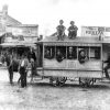
Federal and state funding became available for highways early in the 1920s, as automobile and truck traffic was beginning to take the place of railroad traffic. The roads that would become U.S. Highway 67 were first designated part of the original Arkansas State Highway System in 1923. A joint commission of the U.S. Bureau of Public Roads and the American Association of State Highway Officials created the first national system of highways, with nine federal highways established in Arkansas, including Highway 67. Sections of the highway were gradually improved as funds became available. Much pavement was laid for the highway in 1928 through 1931. The highway was eighteen feet wide at that time. More improvements were made by federal projects such as the Works Progress Administration (WPA) in the 1930s.
The establishment of an ordnance plant in Jacksonville in 1941 was significant for the highway, as thousands of workers needed to travel back and forth between Little Rock and Jacksonville; the road was quickly widened to accommodate the traffic. After the war, the United States entered a period of prosperity and growth that led to cultural changes. Many of the earliest rock and roll performers—including Elvis Presley, Johnny Cash, Conway Twitty, and Sonny Burgess—performed in high schools, nightclubs, and other venues along Highway 67 from Newport north to Pocahontas. In 2009, the Arkansas General Assembly named this part of the highway the Rock ’n’ Roll Highway, with a portion also in Miller County in southwestern Arkansas, as early rock and roll performers sometimes played at Arkansas Municipal Auditorium when they traveled through Texarkana on Highway 67.
Also during the 1950s, American views of highway travel began to change. Until this time, highways existed to connect cities and towns to one another. The beginning of the interstate highway system caused drivers to begin traveling directly between large cities, bypassing the smaller cities and towns. Interstate 30, from Little Rock south to Texarkana and then into Texas, was one of the original interstate highways planned for Arkansas. The new interstate highway made travel into Texas easier but took business away from many of the communities that had relied on travelers’ income to support stores, restaurants, and gas stations. Meanwhile, many segments of Highway 67 were widened or replaced with wider pavement between 1952 and 1958. Highway 67 has continued to be used by Arkansans traveling shorter distances in the southwestern quarter of the state.
Little Rock was also connected to Memphis, Tennessee, and to Fort Smith (Sebastian County) by Interstate 40, but no interstate highway led out of central Arkansas to the north. Over the years, consideration was given to creating an interstate highway along the route of Highway 67, and both Arkansas and Missouri began improving the highway, making it a divided four-lane highway. As of 2016, Highway 67 has been improved as far as Hoxie.
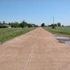
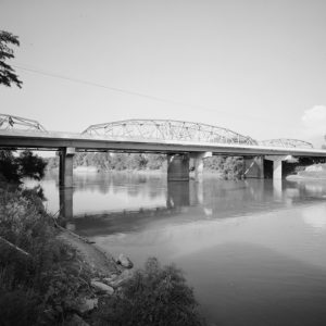
Several portions of the older structure of the highway have been placed on the National Register of Historic Places. These include two stretches of pavement, each about eleven miles long, in Clay, Randolph, and Lawrence counties; a stretch of pavement between five and six miles long in Miller County; and a bridge and a rest area in Clark County. The rest area was built by the National Youth Administration (NYA) in 1936.
For additional information:
Hanley, Ray. Images of America: A Journey through Arkansas, Historic U.S. Highway 67. Charleston, SC: Arcadia Publishing, 1999.
Historical Review, Volume Two: Arkansas State Highway Commission and Arkansas State Highway and Transportation Department, 1913–2003. Little Rock: Arkansas State Highway and Transportation Department, 2004.
Mancino, Parker. “Celebration Held for I-57 Designation.” Arkansas Democrat-Gazette, November 8, 2024, pp. 1B, 3B. Online at https://www.arkansasonline.com/news/2024/nov/07/celebration-held-in-beebe-for-i-57-designation/ (accessed December 4, 2025).
Nelson, Rex. “Rockin’ Down the Highway.” Arkansas Democrat-Gazette, January 3, 2021, pp. 1H, 6H. Online at https://www.nwaonline.com/news/2021/jan/03/rockin-down-the-highway/ (accessed December 4, 2025).
“Old U.S. 67, Alicia to Hoxie.” National Register of Historic Places nomination form. On file at Arkansas Historic Preservation Program, Little Rock, Arkansas. Online at https://www.arkansasheritage.com/docs/default-source/national-registry/lw0081-pdf.pdf?sfvrsn=647b4603_0 (accessed December 4, 2025).
“Old U.S. 67, Biggers to Datto.” National Register of Historic Places nomination form. On file at Arkansas Historic Preservation Program, Little Rock, Arkansas. Online at https://www.arkansasheritage.com/docs/default-source/national-registry/ra0105-pdf.pdf?sfvrsn=ce94f6d2_0 (accessed December 4, 2025).
“Old U.S. 67, Mandeville.” National Register of Historic Places nomination form. On file at Arkansas Historic Preservation Program, Little Rock, Arkansas. Online at https://www.arkansasheritage.com/docs/default-source/national-registry/mi0135-pdf.pdf?sfvrsn=af510c0f_0 (accessed December 4, 2025).
“Old U.S. 67 Rest Area.” National Register of Historic Places nomination form. On file at Arkansas Historic Preservation Program, Little Rock, Arkansas. Online at https://www.arkansasheritage.com/docs/default-source/national-registry/cl0430-pdf.pdf?sfvrsn=bf11b2ee_0 (accessed December 4, 2025).
Smith, Jeffrey. “A Faster Route to Chicago As Hwy. 67 Renamed I-57.” The Leader, November 13, 2024, pp. 1, 6.
“U.S. 67 Bridge over the Little Missouri River.” National Register of Historic Places nomination form. On file at Arkansas Historic Preservation Program, Little Rock, Arkansas. Online at https://www.arkansasheritage.com/docs/default-source/national-registry/cl0949-pdf.pdf?sfvrsn=14f3fb29_0 (accessed December 4, 2025).
Steven Teske
Butler Center for Arkansas Studies


Comments
No comments on this entry yet.