
501-918-3025
calsfoundation@cals.org
calsfoundation@cals.org
Stretching from the Missouri border in the north to McGehee (Desha County), Arkansas Highway 1 spans almost 160 miles in the eastern part of the state. Part of the original state highway system, the roadway continues to be an important route in the Delta.
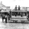
The highway originated from a number of local roads constructed in the nineteenth and early twentieth centuries. A 1916 state road map includes several sections of the future highway, but most of the route does not yet appear. With the establishment of the state highway system in 1923, much of the route appeared on the official map. Improvements to the road over the decades brought Arkansas Highway 1 to modern standards while continuing to follow much of the same route established in 1924.
The southern end of the roadway begins at an intersection in McGehee with U.S. Highway 165, passing both McGehee High School and the University of Arkansas at Monticello (UAM) College of Technology in a northeasterly direction. Crossing the Boeuf River, the two-lane highway passes through Rohwer (Desha County), the site of one of two Japanese American internment camps in Arkansas during World War II. Continuing to the north, the roadway passes through the town of Watson (Desha County), where it crosses the Delta Heritage Trail.
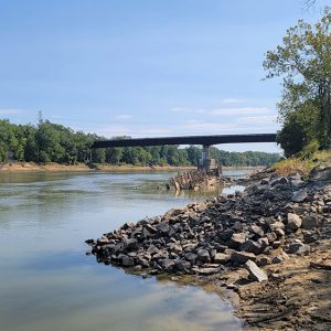
Moving through Watson, the road turns to the west, passing through Pea Ridge (Desha County) before intersecting with U.S. Highway 165 at Back Gate (Desha County). Arkansas Highway 1 joins U.S. Highway 165 in a concurrent route to the north. The roadway crosses the Arkansas River at Pendleton (Desha County) and enters Arkansas County. Passing the Arkansas Post Museum State Park, the road is intersected by Arkansas Highway 169, which leads to Arkansas Post National Memorial. Continuing northward, the roadway passes on the eastern side of Gillett (Arkansas County). Entering the city limits of DeWitt (Arkansas County), the two highways diverge, with U.S. Highway 165 running alongside the west side of the town while Arkansas Highway 1 follows the east side and is known as South Whitehead Drive and North Whitehead Road. Arkansas Highway 1 Business separates from the main route on the south end of DeWitt, running concurrently with South Monroe Street before joining South Jefferson Street. At the intersection with West Second Street, Arkansas Highway 1 Business turns to the east, where it rejoins the main route. The highway continues to the northeast to the town of St. Charles (Arkansas County). A spur route of Arkansas Highway 1 runs through the town, while the headquarters of the Dale Bumpers National Wildlife Refuge are located on the south side of the road. The spur terminates at a boat ramp on the White River, while the main route crosses the stream, entering Monroe County. Passing the Cross Road (Monroe County) community, the road enters Phillips County, passing through the Turner (Phillips County) community before intersecting with U.S. Highway 49 at Marvell (Phillips County).
The two highways form a concurrent route to the east, with the route including four lanes with a center turning lane. At Walnut Corner (Phillips County), the roads diverge, with Arkansas Highway 1 turning to the north while U.S. Highway 49 continues to the east. The four-lane route with a turning lane passes to the west of Lexa (Phillips County) and enters Lee County before reaching Marianna (Lee County). A spur of Arkansas 1 runs through the downtown area while the main route runs to the west of Marianna, intersecting with U.S. Highway 79. The two highways form a concurrent route for a short distance before diverging on the northwest side of Marianna.
Continuing to the north, Arkansas Highway 1 becomes a multi-lane divided highway several miles outside of Marianna. The roadway is reduced to a four-lane undivided highway while passing through Haynes (Lee County), although it once again becomes divided on the north side of the community. Entering St. Francis County, the main highway is reduced to two lanes and swings west of Forrest City (St. Francis County), while a business route passes through downtown. Both routes cross U.S. Highway 70 and Interstate 40 before rejoining north of the city. The four-lane undivided roadway continues to the north, passing through both Caldwell (St. Francis County) and Colt (St. Francis County).
Entering Cross County, the highway passes through Wynne (Cross County), intersecting with U.S. Highway 64 on the north side of the city. The two highways run concurrently for a short distance to the west, where they diverge, and Arkansas Highway 1 continues to the north. The two-lane road passes to the west of Vanndale (Cross County), the birthplace of historian C. Vann Woodward, and the town of Cherry Valley (Cross County). Entering Poinsett County, the highway passes through the center of Harrisburg (Poinsett County). Crossing into Craighead County, the highway passes through Jonesboro (Craighead County), where it intersects Interstate 555 and creates a concurrent route with U.S. Highway 49 on the northern side of the interstate. Passing the east side of Arkansas State University, the concurrent route passes Brookland (Craighead County) before entering Greene County. The route passes through the center of both Paragould (Greene County) and Marmaduke (Greene County) before entering Clay County and passing through the south side of Rector (Clay County). The route passes through Piggott (Clay County), intersecting with U.S. Highway 62. Arkansas Highway 1 splits from Highway 62 east of Piggott, moving to the northeast for about five miles until it reaches the St. Francis River. The road continues across the river into Missouri, where it becomes state route BB.
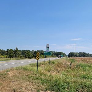
A portion of the highway is part of the Arkansas section of the Great River Road National Scenic Byway. The section of Arkansas Highway 1 between Rohwer and Turner is part of the byway.
For additional information:
“County Maps.” Arkansas Department of Transportation. https://www.ardot.gov/divisions/transportation-planning-policy/gis-mapping/county-maps/ (accessed October 20, 2023).
“Historic Tourist Maps–By Year.” Arkansas Department of Transportation. https://www.ardot.gov/divisions/transportation-planning-policy/gis-mapping/arkansas-state-highway-tourist-map/historic-tourist-maps-by-year/ (accessed October 20, 2023).
Historical Review–Volume Two: Arkansas State Highway Commission and Arkansas State Highway and Transportation Department, 1913–2003. Arkansas Department of Transportation. https://www.ardot.gov/wp-content/uploads/2020/10/History-Book-2004.pdf (accessed October 20, 2023).
David Sesser
Southeastern Louisiana University


Comments
No comments on this entry yet.