calsfoundation@cals.org
Colt (St. Francis County)
| Latitude and Longitude: | 35º07’53″N 090º48’40″W |
| Elevation: | 253 feet |
| Area: | 1.26 square miles (2020 Census) |
| Population: | 293 (2020 Census) |
| Incorporation Date: | April 17, 1916 |
Historical Population as per the U.S. Census:
|
1810 |
1820 |
1830 |
1840 |
1850 |
1860 |
1870 |
1880 |
1890 |
1900 |
|
– |
– |
– |
– |
– |
– |
– |
– |
– |
– |
|
1910 |
1920 |
1930 |
1940 |
1950 |
1960 |
1970 |
1980 |
1990 |
2000 |
|
– |
265 |
267 |
259 |
267 |
394 |
301 |
378 |
334 |
386 |
|
2010 |
2020 |
|
|
|
|
|
|
|
|
|
378 |
293 |
|
|
|
|
|
|
|
|
Colt (St. Francis County), located at the intersection of Arkansas Highway 1 and Highway 306 between the L’Anguille River and Crowley’s Ridge, was an agricultural town that became a stop on several of the main routes through the state. It was a stopping place for many settlers moving out west on Military Road and became the home of Colt Station, a stop on the Iron Mountain Railroad from Memphis, Tennessee, to Fort Smith (Sebastian County). In the twenty-first century, it is used as a research area for agricultural sustainability for the Arkansas Delta.
Louisiana Purchase through Early Statehood
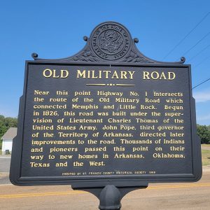
In 1826, William Mitchell Taylor settled near a creek one mile southeast of present-day Colt, where he built a large log house on the western edge of Crowley’s Ridge. This area became known as Taylor’s Creek. He relocated to this area from Tennessee and helped build the Military Road. Because of the Military Road, many Native Americans and pioneers passed through this area on their way out west during Indian Removal. The Taylor home became a stagecoach and mail stop during this time.
As the area grew in population, the community of Taylor’s Creek was established, east of the present-day city of Colt. This community was formed when the Military Road from Memphis to Little Rock (Pulaski County) extended across St. Francis County. William Strong, St. Francis County’s second judge also settled in what is now Colt. He was one of the main backers in the county to get the Military Road established and built in the 1820s.
Civil War through Reconstruction
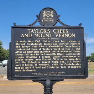
Taylor’s Creek and the surrounding area that became Colt was a loose collection of people that never really developed into a larger town. It was the site of a Civil War skirmish on May 11, 1863. This skirmish was between 1,200 Federal cavalry and a slightly superior Confederate force. A few men were killed on each side, and the Federal force retreated after a brisk fight.
Post Reconstruction through the Gilded Age
The city of Colt was founded in 1882, when the Helena Branch of the Iron Mountain and Southern Railroad came through and established a station. Colt Station was a shipping and stagecoach stop for people traveling from Memphis to Fort Smith. The station took its name after a railroad contractor; a coin toss, according to a local story, decided Colt over Williamsville. Many of the residents thought that the new town should be named Taylor in honor of Mitchell Taylor, but Taylor declined.
William Stone, a local businessman, built his house in Colt in 1884. From the late 1800s into the early 1900s, the Williams family grew in prominence in Colt. Nat G. Williams Sr., a member of the Twenty-third Arkansas Infantry in the Civil War, was one of the first settlers in the area and his family went on to become well known in business and politics.
Early Twentieth Century through the Faubus Era
By 1905, Colt Station was a thriving area with a school, doctor, multiple churches, hotels, pool halls, sawmills, a toy factory, an axe handle factory, several stores, and blacksmiths. At the time of incorporation in 1916, the city consisted of two cotton gins, six general stores, one drugstore, and two sawmills. Later, Stone sold his home to Captain Henry S. Richardson, a former Confederate captain in the Civil War who became the first mayor of Colt. Lawrence F. Williams owned the other sawmill as well as a store in city.
March of Time was a monthly documentary series produced by CBS from 1935 to 1951 that addressed social issues of the time. The 1937 August episode covered the plight of both black and white sharecroppers of the South in The Land of Cotton: The Plight of the Sharecroppers. This documentary was filmed in Colt, and many of the actors were locals. The film was directed by Jack Glen and produced by James Agee.
Modern Era
Colt is still a farming community with local businesses that support farmers’ agricultural needs, such as Hobbs Farm Equipment. Due to its location between Interstate 40 and Jonesboro (Craighead County), it is also a profitable environment for transportation companies such as Cummings Trucking, Delta Carrier, and Lucas Trucking.
Colt houses a branch of the Arkansas Agricultural Experiment Station. The Pine Tree Research Station consists of approximately 12,000 acres of land, which includes 8,000 acres of timber or woodlands and 3,500 acres in cropland or otherwise open land. Their mission involves crop research, foundation seed production, timber research, and wildlife management. Research on grain crops such as rice, wheat, soybeans, grain sorghum, and corn spans several disciplines, including control or management of diseases, insects, and weeds; soil fertility; variety development; and crop management practices such as irrigation, row spacing, planting methods, and rotations. The soils and conditions of the Pine Tree (St. Francis County) location are typical of much of the lowland crop-producing region of Arkansas.
Education
The Colt School was enlarged in 1901 when the Oak Hill School was moved and added to the Colt building. S. M. Blalock was a teacher or principal of the school from 1900 to 1902. Nat Williams was one of the directors, along with Frisk Wolfe and a Dr. Ratcliff. In 1905, the Colt School was in session ten months out of the year. Colt consolidated with some of the local schools and, around 1916, became Special School District No. 25. At this time, it also included a high school. In 1928, Colt built a new school building to replace the previous facility; this was destroyed by a tornado in 1930. It was rebuilt around 1931 and added the youth of Pine Tree when the Macedonia (St. Francis County) school was closed in the late 1940s. This building served Colt until it burned on September 6, 1955. In the twenty-first century, the youth in Colt now have a choice between Wynne (Cross County) and Forrest City (St. Francis County) public school districts, as well as a number of smaller private schools in the area.
Attractions and Famous Residents
Pioneer Days in September is sponsored annually by the Colt Community Development Corporation (CCDC) and is held at the historic William Stone House. The event includes gospel music from several musical groups, fare from the CCDC food booth, historical displays, informational booths, and handcrafts.
The William Stone House was listed on the National Register of Historic Places in 1993 as the best example in Colt of a Plain Traditional house with applied Colonial Revival and Folk Victorian detail. It is sponsored by the CCDC. It also holds displays on the history of northern St. Francis County and is open by appointment.
Charlie Rich, a country music singer, was born in Colt in 1932.
For additional information:
Chowning, Robert W. History of St. Francis County, Arkansas 1954. Forrest City, AR: Times Herald Publishing Company, 1954.
Ellis, Richard Owen. Pine Tree Times: History of the L’Anguille Township in St. Francis County and the Ellis Township in Cross County. Tulsa, OK: The Printing Company, 2003.
Fielding, Raymond. The March of Time, 1935–1951. New York: Oxford University Press, 1978.
Mitchell, H. L. “The Founding and Early History of the Southern Tenant Farmers Union.” Arkansas Historical Quarterly 32 (Winter 1973): 342–369.
“William Stone House.” National Register of Historic Places nomination form. On file at Arkansas Historic Preservation Program, Little Rock, Arkansas.
Stephanie Darnell
Forrest City, Arkansas
 Entering Colt
  Colt City Hall and Fire Dept.
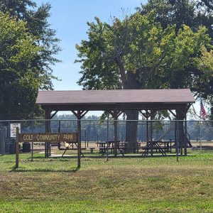
  Colt Community Park
  Colt Post Office
  Colt Street Scene
  Colt Street Scene
  Delta Regional Airport
  Old Military Road
  "The Most Beautiful Girl in the World," Performed by Charlie Rich
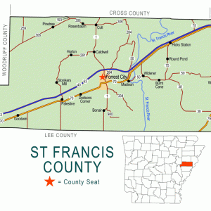
  St. Francis County Map
  Taylor's Creek and Mount Vernon Skirmishes


Comments
No comments on this entry yet.