

501-918-3025
calsfoundation@cals.org
calsfoundation@cals.org
U.S. Highway 64 crosses the state of Arkansas, connecting Fort Smith (Sebastian County) to West Memphis (Crittenden County). It passes through eleven counties of the state. In western Arkansas, it travels the Arkansas River Valley and parallels Interstate 40; in eastern Arkansas, it transverses the Mississippi River Delta significantly north of the Arkansas River and the interstate highway.
Route
Highway 64 runs 2,326 miles from Arizona to North Carolina, passing through six states, including Arkansas. Its route covers 246 miles in Arkansas.
The highway enters Arkansas as a four-lane bridge over the Arkansas River. It rises over the Harry E. Kelley River Park, Belle Point, and the Fort Smith National Historic Site and continues through Fort Smith as Garrison Avenue. Then, it turns left as a divided highway—10th and 11th streets, also designated Business 71. After passing through Fort Smith, the highway again spans the Arkansas River, entering Van Buren (Crawford County). In Van Buren, Highway 64 is first Broadway Street and then Main Street. After a cloverleaf exchange with Interstate 540, it becomes the Alma Highway. Continuing just south of I-40, the highway goes to Alma (Crawford County), running then east to Dyer (Crawford County) and Mulberry (Crawford County).
Continuing east alongside the interstate, Highway 64 passes through Ozark (Franklin County), Wiederkehr Village (Franklin County), and Altus (Franklin County). It visits Coal Hill (Johnson County) and Hartman (Johnson County), then crosses Interstate 40 before arriving at Clarksville (Johnson County). From there, it runs to Lamar (Johnson County), where it again is called Main Street. Crossing the interstate a second time by Lake Dardanelle, the highway runs through Knoxville (Johnson County) and London (Pope County) before continuing to Russellville (Pope County), where it again is designated Main Street. Staying close to the interstate through Pottsville (Pope County) and Atkins (Pope County)—where again it becomes Main Street—Highway 64 then travels southeast to Morrilton (Conway County) before turning straight east again. Passing through Plumerville (Conway County)—again as Main Street—and Menifee (Conway County), Highway 64 hooks south to Gleason (Faulkner County), then turns east again as Old Morrilton Highway. This brings the highway to Conway (Faulkner County), where it joins with U.S. Highway 65-B.
Becoming Oak Street in Conway, Highway 64 crosses Interstate 40 and heads east, while the interstate follows the river valley south toward North Little Rock (Pulaski County). Bypassing Vilonia (Faulkner County) to the south, the highway continues east to Beebe (White County), where it meets U.S. Highway 67. The highways combine (as the Rock and Roll Highway) and head northeast to Searcy (White County) and then to Bald Knob (White County), where they separate. Highway 64 then heads east through Worden (White County) before crossing the White River just west of Augusta (Woodruff County). The highway continues east, passing through farmland to the north of Patterson (Woodruff County) and McCrory (Woodruff County); farther east, it crosses the northern extremity of Wynne (Cross County).
From Wynne, the highway winds through more farmland before crossing the St. Francis River just west of Parkin (Cross County). From Parkin, it continues east to Earle (Crittenden County), then travels southeast to Crawfordsville (Crittenden County). From there, it heads to Marion (Crittenden County), where it encounters Interstate 55. Joining the interstate (as does U.S. Highway 63), Highway 64 continues to West Memphis, where it uses the interstate bridge to travel across the Mississippi River to Memphis, Tennessee.
History
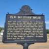
The Arkansas River Valley has been a travel route across Arkansas for centuries. Land routes and railroads preceded the modern highways, which in turn have been superseded by the interstate highway system. Moreover, a segment of Highway 64 in Crittenden County follows the historic Military Road, one of the first designated travel routes in Arkansas.
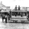
The creation of Arkansas’s highway commission in 1913 meant a more systematic oversight of roads and highways than had been possible under local control. In 1925, a joint committee of the U.S. Bureau of Public Roads and the American Association of State Highway Officials created a plan of national highways that included Highway 64. The designation linked individual roads already built to connect cities and towns and also prompted new highway construction to accomplish that linkage. The highway commission reported that nine percent of the roads in Arkansas were paved at the end of calendar year 1926. Throughout the 1920s and 1930s, Highway 64 and its partner highways were improved—much of the work done in the 1930s by the Works Progress Administration (WPA). The emergence of the interstate highway system in the 1950s removed much of the traffic from Highway 64, although it has continued to be used for more local travel and as an option to the interstates.
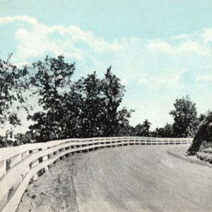
Several properties associated with U.S. Highway 64 are listed on the National Register of Historic Places: Old U.S. 64, Menifee Segment (listed March 2, 2006), Old U.S. 64, Scotia Segment (listed September 19, 2007), Old U.S. 64, Van Buren Segment (listed January 21, 2010), and U.S. 64 Horsehead Creek Bridge (listed September 29, 2014).
For additional information:
Historical Review. Vol. 2: Arkansas State Highway Commission and Arkansas State Highway and Transportation Department, 1913–2003. Little Rock: Arkansas State Highway and Transportation Department, 2004.
Steven Teske
Butler Center for Arkansas Studies


Comments
No comments on this entry yet.