calsfoundation@cals.org
Mulberry (Crawford County)
| Latitude and Longitude: | 35º30’02″N 094º03’06″W |
| Elevation: | 404 feet |
| Area: | 7.83 square miles (2020 Census) |
| Population: | 1,543 (2020 Census) |
| Incorporation Date: | November 8, 1880 |
Historical Population as per the U.S. Census:
|
1810 |
1820 |
1830 |
1840 |
1850 |
1860 |
1870 |
1880 |
1890 |
1900 |
|
– |
– |
– |
– |
– |
– |
– |
– |
321 |
361 |
|
1910 |
1920 |
1930 |
1940 |
1950 |
1960 |
1970 |
1980 |
1990 |
2000 |
|
722 |
1,095 |
895 |
973 |
952 |
934 |
1,340 |
1,444 |
1,448 |
1,627 |
|
2010 |
2020 | ||||||||
|
1,655 |
1,543 |
Located in the Interstate 40 corridor, Mulberry is positioned near cultural and business activities in northwest Arkansas. It is a center of recreation surrounded by rich farmland in the Arkansas River Valley.
Louisiana Purchase through Early Statehood
Although the area where modern-day Mulberry is located had been given by treaty to Spain at the close of the French and Indian War in 1762, Jean Baptiste Dardenne, a French settler, surveyed the land and laid claim to much of it, though he probably settled farther down the river. White settlers began arriving in the Mulberry area near the time of the Louisiana Purchase. Early settlers called the stream passing through “Mulberry” because of the large mulberry trees lining its banks. Dardenne sold part of his survey in 1816 to William Russell, Simon Miller, and son Jesse. They raised one crop in this new frontier before the former Osage lands, from the White River to the Arkansas River, were given by treaty to the Cherokee. In 1828, a new treaty moved the Cherokee farther west and, again, permitted white settlement in the area; rapid growth followed.
Several early settlements existed in the Mulberry valley; the most prominent was Pleasant Hill. It was built around the school on the site of what was called the Presbyterian Campground, located near the present juncture of I-40 and Highway 215. The camping area was used by the early settlers, missionaries, and preachers for evangelistic religious gatherings after the crops were harvested each fall. Built on the edge of Big Mulberry, this area had a meeting house and a wagon shed, and houses began to spring up around it. It was one of the few settlements that continued to exist through the Cherokee occupation from 1818 to 1828. The first post office was opened in the early 1830s, and a Cumberland Presbyterian church was organized there in 1832. The settlement grew to include a school, several churches and stores, doctors’ and druggists’ offices, and a stage stop.
Civil War through Reconstruction
Although there were only minor skirmishes around Mulberry, the Civil War took a toll both physically and economically. Several members of a local Confederate company were killed when they returned home to visit their families. Both Confederate and Federal guerillas operated in the area, destroying crops, stealing, plundering, and harassing citizens. Many families lost their possessions and livelihoods.
Post Reconstruction through the Gilded Age
With the coming of the Little Rock and Fort Smith Railroad in 1876, a permanent settlement near its path was desired. According to Goodspeed’s Biographical & Historical Memoirs of Northwestern Arkansas, Thomas A. Carter bought the land east of the main road to the river—a road that later became Mulberry’s Main Street—from the heirs of Allan Miller. Robert Henry Hicks, farmer and barrister, purchased the property on the west. Carter erected the first home in 1874; Quesenbury and Company built the first business house in 1876. The town was situated in Maxey Township. Mulberry was located in Franklin County until 1895, when Crawford County received the township, by act of the legislature, in exchange for building a bridge over the Mulberry River. The town was incorporated in the fall of 1880, and John Hudgens was elected mayor.
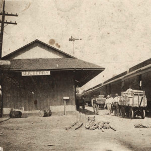
During the first few years of the new town, the Methodists, Presbyterians, and Baptists organized churches. At first, they met together or in rotation at the school location. Also meeting in town in the late nineteenth century was the Second New Hope Missionary Baptist Church, an African-American congregation, which purchased land just north of the train depot for a building in 1886.
Early Twentieth Century through Modern Era
Mulberry had a small black population dating from before the Civil War; most of the men worked at the local Cotton Oil Company or on the farm, while a few of the women served as domestics. Early in the twentieth century, a black man from outside of Mulberry killed the city marshal on Main Street. Fearing a collective retaliation, black citizens fled. It was not until the 1970s that a black family with school-aged children moved back into the area. A few Latinos settled there during the 1940s and 1950s.
The Depression began early and lasted long in Mulberry. Many citizens moved to California to seek employment after their farms were flooded in 1923 and 1927. After the stock market crash of 1929, local men began supplementing the income of their families by fishing, hunting, and trapping. The Works Progress Administration (WPA) provided jobs such as building dams, school facilities, bridges, and rural roads for a number of men in the Mulberry area. Several young men also joined the Civilian Conservation Corps (CCC) in its work in Arkansas and around the nation. The city began to prosper again following World War II.
Modern-day Mulberry is a second-class city with an elected mayor, secretary/treasurer, and six aldermen. The city judge and attorney are contracted. A full-time public works director, an engineer, and other personnel are employed by the city.
Mulberry made national and international headlines when, on August 21, 2022, one Mulberry police officer and two sheriff’s deputies were filmed beating a man they later claimed they were in the process of detaining. Officials quickly denounced their actions, and the officers were placed on leave pending an investigation. The two deputies were later charged with federal civil rights violations.
Attractions
Outdoor recreation facilities in the city and area provide year-round water sports, fishing, and hunting. The Mulberry River is used extensively for canoeing and kayaking; swimming and tubing are permitted on area streams. Recreation areas include Bluff Hole Park and the Vine Prairie Park, under lease agreement with the Corps of Engineers. Pole and rod fishing are permitted on the T. J. House Reservoir. Small game and deer hunting is available in season. The city was designated as a bird sanctuary and also has an abundance of older trees, including the notable willow oaks.
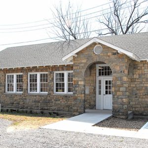
The Crawford County Fairground, located in Kirksey Park near the Senior Inn, has buildings that are used for a host of activities throughout the year; the fair is held each September and includes a rodeo. Mulberry is also home to the Mulberry Community Theater. The Mulberry Home Economics Building, built between 1937 and 1939, is listed on the National Register of Historic Places.
Industry
Farming has always been big business in the Mulberry area. The local farmers raise livestock, chickens, and grow hay, soybeans, and other food crops. Mulberry has an industrial park off Highway 64 West. Area jobs are available in agriculture, trucking, automotive and electrical mechanics, construction, education, and banking.
In 2012, American Vegetable Soybean and Edamame, Inc.—a subsidiary of JYC International based in Houston, Texas—built a 32,000-square-foot plant in Mulberry to process locally grown edamame, a specialized soybean product typically imported from China. The company supplies frozen edamame to Costco, Whole Foods, and Sam’s Clubs. In a press conference, Mulberry was dubbed the “future edamame capital of the United States.”
Education
According to Clara B. Eno, an early Crawford County historian, the school at the Mulberry Campground, probably dating from the late 1820s, was one of the first in the area. The first school in the new town began in 1878 with seventy-eight students. R. H. Hicks donated land on Church Street for the school in 1880, and the school later moved to the present high school campus. Mulberry built a new high school building in 1985, with an addition in 1995. In 2004, the Pleasant View School District was combined with Mulberry to form the Mulberry/Pleasant View Bi-County School District. The high school at Pleasant View (Franklin County) continued to operate through the 2006–2007 school year, at which time those grades were moved to the Mulberry campus. The former Lucy Millsap Elementary at Pleasant View now houses the middle school, while primary grades meet at Marvin Elementary School in Mulberry.
For additional information:
Benham, A. G. A Story of Mulberry. Mulberry, AR: 1976.
Biographical and Historical Memoirs of Northwestern Arkansas. Chicago: Goodspeed Publishing Co., 1889.
Crawford County Bicentennial Commission. An Historical Salute to Crawford County. Van Buren, AR: The Courier, 1976.
Eno, Clara B. History of Crawford County, Arkansas. Van Buren, AR: Press Argus, 1950.
Hopkins, Eula, and Wanda M. Gray, eds. History of Crawford County, Arkansas. Van Buren: Historical Preservation Association of Crawford County, 2001.
Perrier, Ruth B. Arkansas Folklore, 1960. “History of Mulberry, Crawford County, Arkansas.” Special Collections. University of Arkansas Libraries, Fayetteville, Arkansas.
Social Science Department, Mulberry High School. History of Mulberry. Mulberry, AR: 1946.
Nadean Riley Bell
Van Buren, Arkansas
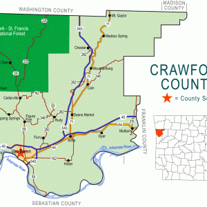
 Crawford County Map
  Mulberry Depot
  Mulberry Home Economics Building


I was surprised there was no mention of Justin Felix Beneux in the early settlers. His two sons were the ones killed when coming home from the war. Justin Beneux was my great-great-grandfather. One of his sons was Homer. His daughter Sally married James Millsap; they were my grandparents. I would like to see his name in your history because he was a big part of Mulberry.
My sister Maurine and I drove from Missouri to Mulberry, AR, on a very stormy day in the 1980s. The local police department was very helpful and told us of a book, A Story of Mulberry by A. G. Benham. We located the author and both purchased his book. Our great-grandfather was Robert Henry (R. H.) Hicks, who was mayor of the town in 1888. He owned the west half of the town, per the book. Also, as the story goes, he and his wife both died about the same time. The orphaned childrenElla (our grandmother), Emma, and Early P. Hickswere raised by our great-grandmother, Louisa Lloyd. We have located our history all the way back to Lydia, Darlington Co., S. C. and the Baptist minister, John Hicks and his wife, Susannah Bryant, and their eleven children. We found that both R. H. and his wife were buried in Quesenbury cemetery, as we drove our rental car in the mud and tall grass to the site. It was dark and pouring rain, no luck on the graves. Fortunately, we located a person living in Mulberry who went to the cemetery and located the headstone, which was broken but readable; she did a rubbing for us and took a photo of it. Later on, we moved and, as usual, we carried the Hicks family Bible with us. A folded paper fell from it and lo and behold it was Robert Henry Hicks paperwork for Justice of the Peace of Mulberry, AR, with the great seal on it. I made copies of it and sent the original to Little Rock, AR, to be kept and copied for other cousins or relatives who might be interested; it is still there.