
501-918-3025
calsfoundation@cals.org
calsfoundation@cals.org
Stretching almost the entirety of the state from south to north, Arkansas Highway 7 crosses eleven counties and measures more than 208 miles.
The highway begins at the Arkansas border with Louisiana near the settlement of Lockhart. It is a continuation of Louisiana State Highway 558. The two-lane road crosses into Union County and merges with U.S. Highway 167 south of El Dorado (Union County). The two roads form a concurrency bypass to the northern edge of the city where Highway 7 continues in a northwestern direction to Smackover (Union County). A multi-lane roadway for this portion, the highway crosses into Ouachita County near Louann (Ouachita County) before it enters Camden (Ouachita County).
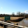
At the interchange with U.S. Highway 79, Highway 7 narrows to two lanes and goes through downtown Camden, where it forms a concurrency with U.S. Highway 79 Business. North of the city, the highway crosses the Ouachita River on the Ben Laney Bridge. The route parallels the Ouachita River for several miles, leading to occasional closures due to high water. The road also passes under a low railroad bridge, preventing most large vehicles from using this portion of the route. Continuing north, the highway enters Dallas County near Ouachita (Dallas County).
The route goes north through Sparkman (Dallas County) before reaching Dalark (Dallas County) and forming a concurrency with Arkansas Highway 8. At Dalark, the highway enters Clark County and crosses the Ouachita River again at Arkadelphia (Clark County). Highway 7 begins a concurrency with U.S. Highway 67 in downtown Arkadelphia and separates from Arkansas Highway 8 just six blocks later. In Arkadelphia, the road is known as North 10th Street for much of its length and passes between the campuses of Henderson State University and Ouachita Baptist University, marking the division that football teams must cross to play the Battle of the Ravine game. Continuing north, Highway 7 crosses the Caddo River and enters Caddo Valley (Clark County), where Highway 67 separates. Access to Interstate 30 is available via an exchange in Caddo Valley.
The roadway continues north, crossing a dike at the eastern end of DeGray Lake and enters Hot Spring County. The highway passes through Bismarck (Hot Spring County), where it crosses Arkansas Highway 84. Continuing north, the highway enters Garland County before crossing several bridges over Lake Hamilton in Hot Springs (Garland County), where it is named Central Avenue. These crossings mark the third and final time the highway crosses the Ouachita River.
In Hot Springs, the multi-lane undivided roadway includes an interchange with U.S. Highway 270 and passes Oaklawn Race Track. Entering the downtown portion of the city, the roadway narrows, with portions of the route with three lanes (two south and one north) and other sections with only two lanes before a four-lane portion passes Bathhouse Row and the Arlington Hotel.
At the intersection of Central Avenue and Whittington Avenue, Highway 7 continues northeast and is named Park Avenue. At the intersection with Arkansas Highway 5 northeast of Hot Springs, Highway 7 turns in a northwestern direction and passes the western edge of Hot Springs Village (Garland and Saline counties) before passing through Jessieville (Garland County). Entering Perry County, the roadway crosses the Ouachita National Recreational Trail before entering Yell County. At Ola (Yell County), the highway begins a concurrency with Arkansas Highway 28 that ends at Centerville (Yell County). At Dardanelle (Yell County), the highway begins a concurrency with Arkansas Highway 27 and crosses the Arkansas River into Pope County. Entering Russellville (Pope County), the highway intersects with U.S. Highway 64 and passes the campus of Arkansas Tech University. An interchange with Interstate 40 is also located in Russellville. Highway 7 separates from Highway 27 at Dover (Pope County).
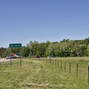
Entering Newton County, the highway passes through Jasper (Newton County), and travelers can view the former Dogpatch USA park north of the town. Crossing into Boone County, Highway 7 enters Harrison (Boone County) and creates a short concurrency with U.S. Highway 65. Highway 7 continues northeast until a junction with Arkansas Highway 14 at Lead Hill (Boone County). The highway splits from Highway 14 at Diamond City (Boone County) and continues north through the town before terminating near the shore of Bull Shoals Lake.
The history of the highway began with the early trails and rough roads created in the state. What became Arkansas Highway 7 first appears on a state highway map published in 1924. The southern end of the route is much the same as today’s, with both unimproved and paved roads from the Louisiana state line to north of Jessieville. The section through Perry County to Ola does not appear on the map, but it continues to follow roughly the modern route from Ola through Dardanelle, Russellville, and Jasper to Harrison. The last section through Lead Hill to Diamond City does not appear.
By 1936, the numbered highway began in El Dorado with access from the state line to that city provided by U.S. Highway 167 and other local roads. The route through Ouachita, Clark, Hot Spring, and Garland counties in 1936 appears to be much the same as the modern-day route. County highway maps show the road in Boone, Garland, and Perry counties completed, also roughly following the modern-day route.
In 1993, the section from Arkadelphia to Harrison was named as the first Arkansas Scenic Byway. Six years later, the section from the Louisiana state line to Arkadelphia was added. The portions of the highway that pass through the Ouachita and Ozark National Forests have been given a National Forest Scenic Byway designation. The highway continues to be an important route in the twenty-first century.
For additional information:
“1936 County Maps.” Arkansas Department of Transportation. https://www.ardot.gov/divisions/transportation-planning-policy/gis-mapping/county-maps/1936-county-maps/ (accessed October 5, 2022).
“Arkansas Scenic 7 Byway.” America’s Scenic Byways. https://scenicbyways.info/byway/2155.html (accessed October 5, 2022).
“County Maps.” Arkansas Department of Transportation. https://www.ardot.gov/divisions/transportation-planning-policy/gis-mapping/county-maps/ (accessed October 5, 2022).
Lancaster, Bob. “Son of Seven.” Arkansas Times, April 1992, pp. 3641, 72–74.
———. “Up Seven: A Report on Our Best-Known Scenic Highway.” Arkansas Times, October 1983, pp. 66–71, 73–74, 76, 78–79.
Nelson, Rex. “Back on the Road.” Arkansas Democrat-Gazette, December 17, 2017, pp. 1H, 6H.
———. “Roaming along 7.” Arkansas Democrat-Gazette, December 10, 2017, pp. 1H, 6H.
“Scenic Byways.” Arkansas Department of Transportation. https://www.ardot.gov/divisions/right-of-way/row_sections/beautification-section/scenic-byways/ (accessed October 5, 2022).
David Sesser
Southeastern Louisiana University


Comments
No comments on this entry yet.