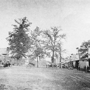
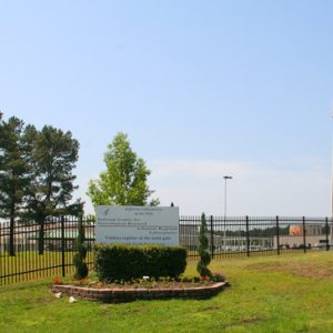
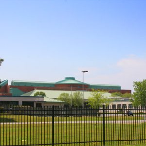
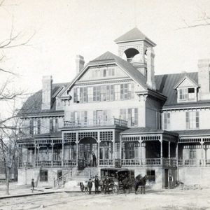
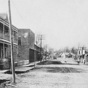
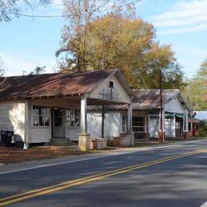
 Nashville Street Scene
Entry Type: Place
Nashville Street Scene
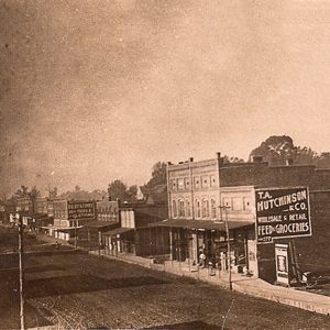 Nashville Street Scene
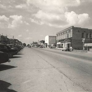 Nashville Street Scene
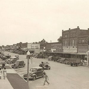 Nashville Street Scene
Nathan (Pike County)
Nathan (Pike County) is a small community founded in the mid-1800s. Although it began as a farming community, by the early 1900s, its economy was driven by the numerous logging operations established in the area. In the twenty-first century, the residential community stretches along Gum Tree Road approximately a half mile off of State Highway 369 in western Pike County near the Howard County border. Several families settled in the area by the 1830s, the most significant to the town’s development being that of Pleasant White. While White is reported to have settled in 1829, no land grant document is found before 1855. More evidence confirming his settlement is the burial of his eldest infant child, Anthony, in the area cemetery …
National Center for Toxicological Research (NCTR)
The National Center for Toxicological Research (NCTR) in Jefferson (Jefferson County) is thirty-five miles southeast of Little Rock (Pulaski County) and twenty miles north of Pine Bluff (Jefferson County). The site, consisting of 496 acres in Jefferson County with numerous buildings and research laboratories, is under the control of the federal Food and Drug Administration (FDA), which was part of the Department of Health, Education, and Welfare (HEW) at the time the center formed. HEW became the Department of Health and Human Services (DHS) in 1980. The facility addresses the toxicity of various chemicals and pharmaceutical drugs, assesses the risks of microbial food contamination, and identifies microbiological pathogens that could be used for acts of terrorism. Including various contractors, research …
 National Center for Toxicological Research (NCTR)
 National Center for Toxicological Research (NCTR)
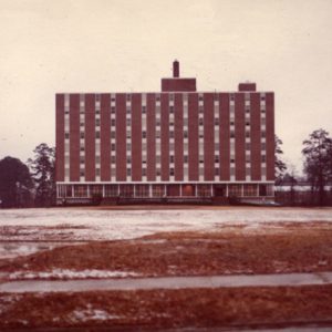
National Park College
National Park College (NPC), formerly National Park Community College (NPCC), is located in Mid-America Park just west of Hot Springs (Garland County). It offers associate degrees, technical certificates, continuing education, community services, workforce training, and adult basic education. NPC is the fourth-largest community college in Arkansas. National Park College resulted from Act 678 of the 2003 Arkansas General Assembly, which merged Garland County Community College (GCCC) and Quapaw Technical Institute (QTI). The act went into effect on July 1, 2003. GCCC had been established as a two-year college in 1973 to provide post-secondary higher education opportunities to the citizens of Garland County and the surrounding areas. QTI was first established as Quapaw Vocational Technical School, a branch campus of the Ouachita …
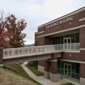 NPCC Lab Science Building
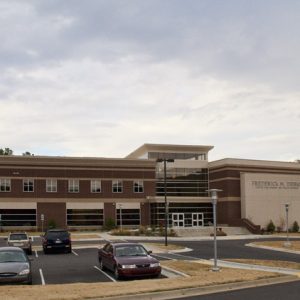 NPCC Dierks Building
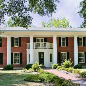
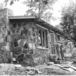 Native Stone House
Natural State Golf Trail
The Natural State Golf Trail is a public-private partnership created to showcase the scenic golf courses of the state. The trail consists of twelve courses in eleven different locations across the Arkansas. First discussed in the early 2000s, the Natural State Golf Trail came about due to the efforts of Lang Zimmerman, a co-founder and managing partner of Big Creek Golf and Country Club in Mountain Home (Baxter County), and because of the interest of Mike Beebe, then serving as an Arkansas state senator. Beebe suggested the possibility of a statewide golf trail to the Arkansas Department of Parks and Tourism, and with the help of Jim Shamburger— a commissioner on the Arkansas State Parks, Recreation and Travel Commission and …
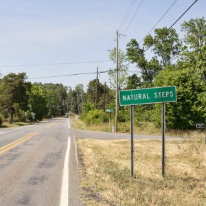
Natural Steps (Pulaski County)
Natural Steps is an unincorporated community located on Highway 300 between Lake Maumelle and the Arkansas River in Pulaski County. It takes its name from a unique sandstone formation in the shape of parallel stair steps. A 1932 archaeological investigation into the Natural Steps area conducted by staff at the University of Arkansas (UA) in Fayetteville (Washington County) uncovered fifty-seven burials, as well as pottery from both the Quapaw and Caddo tribes. An exact sequence of Native American habitation of the area, however, remains unknown. A Spanish land grant conveyed land at Natural Steps to Eli Stidwell. Another early white settler was John Standlee, who was in the area from 1778 to 1780. In the 1810s, merchant John Taylor purchased …
 Natural Steps
Nebraska (Scott County)
Nebraska is a historical community that was located in eastern Scott County along the Fourche La Fave River valley. The town was established in 1854 as an agricultural community prior to the Civil War. Nebraska was originally located between the current communities of Harvey (Scott County) and Nola (Scott County). Archaeological evidence from the Archaic, Woodland, and Mississippian periods shows native people living along the Fourche La Fave River valley near Nebraska. Prior to European exploration, the Caddo tribe lived along the valley. Thousands of archeological sites and burial mounds are located throughout the area. During the late seventeenth and early eighteenth centuries, French hunters and tradesmen explored the waters of the Fourche La Fave River and other tributaries of …
Needmore (Scott County)
The community of Needmore is located along Highway 71 in south-central Scott County. Never officially incorporated as a town, the community stretches from the top of a large hill, known as Needmore Hill, to the hill’s base. Buffalo Creek and the Fourche La Fave River are within a few miles of Needmore. The area where Needmore is now located was once a wilderness inhabited by natives of the Archaic, Woodland, and Mississippian periods. Prior to European exploration, the Caddo tribe lived along the Fourche River Valley. Burial mounds and other archaeological sites can be found along the Fourche La Fave River near Needmore. During the late seventeenth and early eighteenth centuries, French trappers and traders traveled west from Arkansas Post, …
Nella (Scott County)
The unincorporated community of Nella is located in southwestern Scott County. It was established in 1903 along Clear Fork Creek, which is a distributary of the Fourche La Fave River. The agriculture and timber industries have traditionally been important economic resources for the community. Prior to European exploration, the area surrounding Nella was a wilderness. Numerous archaeological sites and burial mounds are located along the banks of prominent waterways such as the Fourche La Fave River. Archaeological findings have provided evidence of early inhabitants dating to the Archaic, Woodland, and Mississippian periods, and the Caddo tribe later inhabited the area. During the late seventeenth and early eighteenth centuries, French hunters and tradesmen traveled west from Arkansas Post exploring portions of …
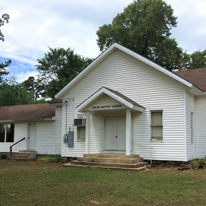 Nella Baptist Church
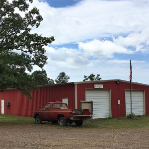 Nella VFD
Nelson, Knox
Knox Nelson was a member of the Arkansas General Assembly for thirty-four years in the second half of the twentieth century, achieving power in legislative halls that was rarely rivaled. Nelson was elected to the state House of Representatives from Pine Bluff (Jefferson County) in 1956 and served two terms, but he attained a position of immense power in the thirty-year career in the state Senate that followed. Governors and groups interested in legislation often had to win Nelson’s favor to get bills passed or defeated in the Senate. Knox Nelson was born on April 3, 1926, in the Goatshed community near Moscow (Jefferson County), a farming community a few miles south of Pine Bluff. His father, Knox Augustus Nelson, …
 Nettleton Hotel
 Nettleton Street Scene
Neuhardt (Crittenden County)
Neuhardt is an unincorporated community in south-central Crittenden County, located on Arkansas Highway 147 between Anthonyville and Edmondson. The town grew up around 1900 as a result of the timber industry and was named for lumber tycoon George Neuhardt, who purchased thousands of timbered acres in the area. Information regarding George Neuhardt is scarce, but it is known that he suffered tremendous commercial losses due to flooding and eventually committed suicide when forced into bankruptcy. Following the Civil War, a statewide timber industry expanded in earnest due to the construction of railroads and availability of powered machinery. Cutting of timber in the Arkansas Delta (including Crittenden County) and the “sunken lands” of northeast Arkansas played a pivotal role in encouraging …
Nevada County
Located in the West Gulf Coastal Plain, Nevada County has a variety of sandy loam and silty clay loam soils, as well as extensive pine and hardwood forests. The Little Missouri River, the major stream in the area, separates Nevada County from Clark and Pike counties to the north. The Reconstruction legislature formed Nevada County in 1871 from Hempstead, Ouachita, and Columbia counties. Prescott, the county seat with a population of 3,101 (as of the 2020 census), is the largest city. Other important towns are Emmet, Willisville, Rosston, Bodcaw, Falcon, Cale, and Bluff City. The reason for the selection of the county’s name has been lost. “Sierra nevada,” as in the Sierra Nevada in California, means “snowy range” in Spanish. …
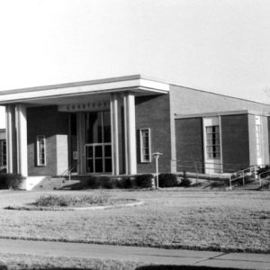 Nevada County Courthouse
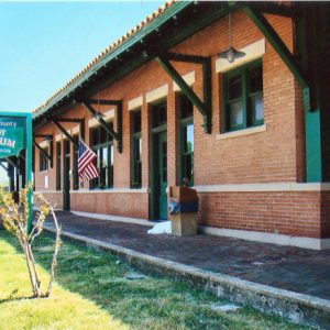 Nevada County Depot and Museum
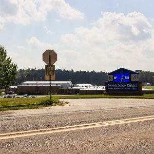 Nevada School District
 New Bethel AME Church
New Edinburg (Cleveland County)
Located on Highway 8 between Warren (Bradley County) and Fordyce (Dallas County) is the town of New Edinburg. Before 1873, it was located in Bradley County. In 1873, Bradley County was divided, and New Edinburg landed in Dorsey County (later renamed Cleveland County). The New Edinburg Commercial Historic District is listed on the National Register of Historic Places. Native American tribes likely traveled through the area and may have settled along the banks of the Saline River. Many artifacts have been found to support this. Several white families settled in the area in the 1830s. These first families—Marks, Smith, Davis, Crain, Washburn, McDaniel, and Hudson—were wealthy, possessed many slaves, and were well educated. By the 1840s, a group of businessmen met at …
 New Edinburg Commercial Historic District
New Edinburg Commercial Historic District
The New Edinburg Commercial Historic District includes a number of former stores and other businesses located on both sides of Arkansas Highway 8 in New Edinburg (Cleveland County). The district contains a total of eleven buildings constructed between 1898 and 1948, ten of which are contributing. The district was added to the National Register of Historic Places on October 22, 2001. The area around New Edinburg began to be settled in the early to mid-1830s. Early public buildings in the area included a church constructed in 1838 and a Masonic lodge in 1854. Development of the area paused during the Civil War, and the Action at Marks’ Mills occurred just to the northwest of the community. After the end of …
 New Home Church
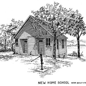 New Home School
New London (Union County)
New London was the main center of commerce in eastern Union County during the Civil War and the forty years afterward. After the railroad bypassed it in 1902, the town was diminished, and all that remained was a collection of houses around a steepled church with an old cemetery. New London began with the arrival of a wagon train from Gilgal, Alabama, in 1839. The wagons carried sixteen families with livestock and some African American slave families, led by a Baptist minister, Elder C. Norsworthy. Two years later, a second wagon train brought eight families. That group came through Alabama but was from Union County, North Carolina, and followed the route that carried most of the pioneers to Texas from …
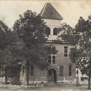
Newark (Independence County)
Throughout much of its history, Newark has been one of Independence County’s larger towns. Called by the local newspaper the “Queen City of South Independence” in the early 1900s, the town held great promise to be a significant part of the history of the county. Like most small towns in early twentieth-century Arkansas, its early years were full of hope and prosperity, but it later suffered the loss of its business community and a significant part of its populace. Post-Reconstruction through the Gilded Age Newark was founded as an alternate site to an older town plagued with a major drawback. The pre–Civil War community of Akron (also known as Big Bottom) was subject to the destructive overflows of the White …
 Newark High School
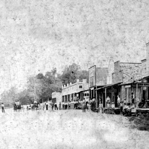 Newark Street Scene
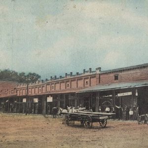 Newark Street Scene
 Newberry Hall
 Newberry House
Newhope (Pike County)
Newhope is a community in Pike County located eight miles west of Daisy (Pike County) and Lake Greeson. The earliest settlers in the area included Andrew Cannon, who obtained 400 acres from the Federal Land Office in Camden in the area in 1860 and 1861. Several other settlers also purchased land in the area at the same time, including John Gafford and Henry Haynes in 1860. The first business to open in the area, a store owned by George Copley, opened in 1876. Copley moved to nearby Star of the West and operated the post office. A second store opened in 1878, and a post office opened under the direction of postmaster Levi Forester. Other businesses opened in the community, …
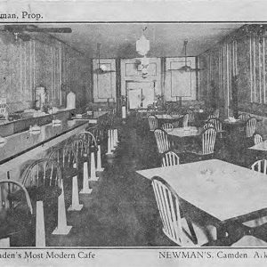 Newman's Cafe
Newport (Jackson County)
Newport is a rural community with deep agricultural ties. Its location on the White River at the transition from the Ozark foothills to the Delta flatland is ideal as a northeast Arkansas crossroads for road, river, and rail traffic. Newport’s economy, based upon natural resources, had strong growth through the first half of the twentieth century and the postwar era. Pre-European Exploration through Early European Exploration Newport is located on a wide bend in the White River where it leaves the Ozark hill country and enters the Mississippi Delta flatlands. It was an ideal crossing point for animals (including deer, bear, and occasionally bison) and for the tribal hunters that followed them. Native people, likely ancestors of the Quapaw, resided …
Newport Air Field
During World War II, one of the army’s seven training airfields built in Arkansas was located at Newport (Jackson County). Over 4,000 men trained during the three years the Newport Army Air Field was in operation. At one point, over 4,800 people were living on the base, more than doubling Newport’s 1940 population of 4,301. Newport was chosen as a site through the encouragement of Congressman Wilbur D. Mills. The flat land already lent itself to airport usage as most trees had been cleared and the ground had been drained for farming. The project was announced in the middle of May 1942, and construction began almost immediately. Thirty-four farm families were displaced from the main site, along with those living …
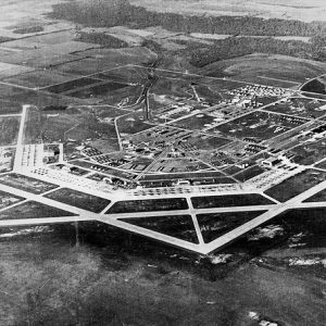 Newport Air Field
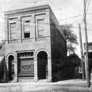 Newport Bank
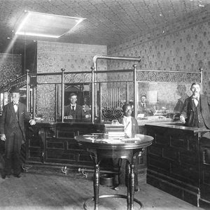 Newport Bank
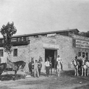 Newport Horse and Mule Market
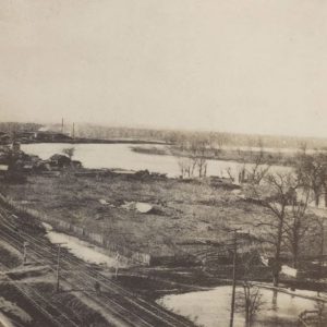 Newport Rail Yards


