501-918-3025
calsfoundation@cals.org
calsfoundation@cals.org
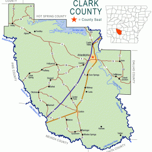
Also known as Britts and Britt’s Switch, Britt is an unincorporated community located in southern Clark County. Situated about three miles west of Beirne (Clark County), the community lies about three miles east of the Little Missouri River. The community lies near the railroad tracks constructed by the Cairo and Fulton Railroad in 1873, continuing to be used today by the Union Pacific Railroad.
Few records exist on the history of Britt. A post office opened in the community on July 6, 1901, under the direction of postmaster Phillip H. Gleaves. He was replaced by Frank Skinner on June 12, 1902. The post office ceased operations on March 31, 1903, with the office in Beirne taking over the service.
Neither Gleaves nor Skinner appear in the 1900 federal census in Clark County. A record for Gleaves’s marriage in 1899 to Mattie Watson lists his residence as Beirne. A man named Frank Skinner does appear in the 1900 census in Hot Spring County, but it is unclear if this is the same person who two years later took the postmaster position. A Frank Skinner also appears in a number of Clark County criminal court records in the 1890s, with charges including slander, openly carrying a weapon, and burglary.
The post office was located on Sixteenth Section land and as such was not dispersed through federal land patents like other nearby parcels. The community appears on a 1936 map published by the Arkansas Department of Transportation but is shown north of the railroad tracks, while the description of the location of the post office as well as a 2011 highway map place the community south of the railroad. The 1936 map shows the community centered on U.S. Highway 67 near the intersection with Arkansas Highway 51, while current maps place the community about one and a half miles to the south. The 1936 map also shows several homes in the community.
Jim Clark operated a sawmill at Britt, although the dates are unknown. A native of Mississippi, Clark moved to Clark County near Okolona as a small child. He opened a sawmill at Beirne around 1887 and expanded his operations, including the mill at Britt. After 1907, Clark resided in Arkadelphia (Clark County) and served as a bank president while also continuing with his timber business.
At least one exploratory oil well operated in Britt in 1921. A second well at Whelen Springs (Clark County) was explored at the same time, but no information on the success of either well is available.
Shady Grove Baptist Church is east of Britt. The African American church has a cemetery located across the road with graves dating to 1845 and additional graves dating to the 1880s. The cemetery continues to be active in the early twenty-first century, although the church is abandoned.
The area remains heavily forested in the early twenty-first century, with multiple plots of land owned by timber companies. A few homes are located in the community but no businesses. The residents commute to Gurdon (Clark County) or other nearby cities for employment. Much of the land is used for hunting, and some deer camps are in the area.
For additional information:
Clark, Charles. “Traveling with the Tax Assessor in Clark County, 1921.” Clark County Historical Journal (2000): 121–126.
Clark County Criminal Records, Ouachita Baptist University Archives, Arkadelphia, Arkansas.
Medley, Willie, and Joe May. “Clark County Postmasters: 1832–1871.” Clark County Historical Journal (1990): 139–160.
Richter, Wendy, et al. Clark County Arkansas: Past and Present. Arkadelphia, AR: Clark County Historical Association, 1992.
David Sesser
Southeastern Louisiana University


Comments
No comments on this entry yet.