calsfoundation@cals.org
Tropical Cyclones
aka: Tropical Storms and Depressions
As defined by the National Hurricane Center, a tropical cyclone is a “rotating, organized system of clouds and thunderstorms that originates over tropical or subtropical waters and has a closed low-level circulation.” Types of tropical cyclones are classified in terms of wind speed: A tropical depression is a tropical cyclone with maximum sustained winds of 38 miles per hour (mph) or lower. A tropical storm is a tropical cyclone with maximum sustained winds of 39 to 73 mph. A hurricane is a tropical cyclone with maximum sustained winds of 74 mph or higher. A major hurricane is tropical cyclone with maximum sustained winds of 111 mph or higher.
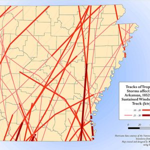
Given the landlocked, central location of the state of Arkansas, it may come as somewhat of a surprise that the paths of forty-five Atlantic or Gulf of Mexico tropical cyclones have crossed the state of Arkansas in some form from when recordkeeping began in 1852 to 2013. Of those, thirty-nine entered Arkansas in a form categorized as a tropical storm (i.e., with wind gusts ranging from 39 to 73 mph); some of these had hurricane-force gusts (over 74 mph). Most were classified as remnant tropical depressions, but even remains can create myriad problems hundreds of miles from their tropical source waters. The major threats from these storms are flooding, emergence of off-season tornadoes that move in unusual directions, and wind damage. Damage to standing crops can be extensive.
The peak season for tropical storms in Arkansas is September, though the state has been directly affected as early as June 14 (an unnamed storm in 1956) and as late as October 11. Although Hurricane Juan was a meandering storm whose center was near the Louisiana coast, it dumped over 6.5 inches of rain on Crossett (Ashley County) on the last days of October 1985.
In late August 2012, and on the heels of a brutal drought, Hurricane Isaac entered the state as a tropical storm, quickly dropping to tropical depression strength; however, its long fetch of tropical moisture caused some impressive rainfall totals into September, especially in Jefferson County: 11.29 inches fell at White Hall (Jefferson County) and 10.65 inches at Pine Bluff (Jefferson County); Griffithville (White County) also received 10.7 inches. Injuries and power outages occurred as drought-stressed trees fell in winds gusting to over forty mph (the highest recorded winds were forty-six mph at Pine Bluff); two tornadoes were reported in Clay County near Corning. Over a five-day period, the storm caused $29.5 million in damage. Hurricane Rita in 2005 spawned eleven tornadoes across Arkansas, with five injuries, and dumped nearly six inches of rain on Star City (Lincoln County). In 2005, as in 2012, much of Arkansas was suffering from a severe drought, but neither Rita nor Isaac dislodged these years from the top ten driest on record.
Twice in September 2008, tropical storms raked the state. Hurricane Gustav inundated much of Arkansas with five to twelve inches of rain, knocking out power and flattening rice crops ready for harvest. Barely two weeks later, Hurricane Ike produced nine confirmed tornadoes and more heavy rain in Arkansas; unofficial gusts of seventy-one mph were recorded by a ham radio operator in Nashville (Howard County), which is in keeping with official reports to the northeast, such as National Weather Service (NWS) reports of hurricane-forcegusts of seventy-eight mph at Grand Rivers, Kentucky.The centers of circulation of both storms remained well-defined for an unusually long period.
Inland hurricane hazards include some astonishing rainfall totals. Allison in 1989 inundated Portland (Ashley County) with 13.91 inches of rain, while 1957 brought two storms producing heavy rain to the state: Bertha in August topped thirteen inches just a short time after Audrey in June dropped more than five inches on Hamburg (Ashley County).
Of fifty-five tropical storms that passed through or very near to the state of Arkansas, one-fifth made landfall in or very near Terrebonne Parish, Louisiana; another fifth landed near the Texas-Louisiana border within about twenty-five miles of Sabine Pass. Most of the rest came ashore on the Texas Gulf Coast, with a rare few making landfall in Alabama and Mississippi. A surprising number of the tropical cyclones listed above had a core (eyewall) that came ashore near or affected Galveston, Texas—if that hurricane-prone city is listed as a target, Arkansans might prepare to be affected. Among those listed are prolific rainmakers such as Audrey, Debra, Felice, Delia, Elena, Bonnie, Rita, and Ike, as well as a 1915 direct hit on Mena (Polk County) that caused record rainfall in the city, as well as setting a one-day record for Harrison (5.7 inches).
Many historic hurricanes have crossed the state, but statistics on them cannot be obtained; it is even difficult to find the origin of the paths obtained from the National Hurricane Center. In 1891, a hurricane that struck Galveston went on to hit Arkansas; in 1879, a Sabine Pass hurricane also crossed the state. A 1909 storm seemingly caused hurricane-force winds in Ashley County (near Crossett), crossing more than half the state with sustained winds of over fifty-five mph. There are many more such storms recorded through 1950 when the NWS began naming storms.
One of the more interesting paths taken by an Arkansas hurricane was that of a storm that began in the eastern Pacific in September 2010 as Tropical Depression No. 11E. The system then moved in an unusual easterly direction, crossed Mexico, and emerged into the Gulf of Mexico to become Tropical Storm Hermine, which brought to the state the eighth-highest rainfall total ever recorded in Arkansas.
In 2024, disaster preparedness in the wake of tropical cyclones became more salient for authorities in Arkansas after the state received the remnants of Hurricane Francine in mid-September, followed by Hurricane Helene later that month. In both cases, Arkansas received only a moderate amount of rainfall, precipitation that proved welcome after an abnormally hot and dry summer, but the amount of damage that Helene produced across the inland Appalachian regions of South Carolina, North Carolina, and Tennessee provided a warning for what might happen if such a system struck the Ouachita and Ozark mountains of Arkansas, given their similar geography and the preponderance of rural communities that could become isolated should major flooding occur. Given that ongoing climate change has resulted in stronger hurricanes, the chances of more tropical cyclones affecting Arkansas has increased.
| Precipitation Amounts from Various Tropical Cyclones Recorded in Arkansas (Since 1950) | |||
| Storm Name (or Designation) / Month-Year | Rainfall (in.) | Location | Other Info. |
| Allison (June–July 1989) | 13.91 | Portland | |
| Bertha (August 1957) | 13.77 | Damascus (Van Buren and Faulkner counties) | |
| Gustav (August–September 2008) | 12.02 | Eudora (Chicot County) | |
| Bonnie (June 1986) | 11.75 | El Dorado (Union County) | |
| Unnamed (June 1960) | 11.16 | Clarendon (Monroe County) | |
| Frances (September 1998) | 10.45 | Sparkman (Dallas County) | |
| Isaac (September 2012) | 10.7 | White Hall | Two tornadoes Clay County |
| Hermine/Tropical Depression No. 11E (September 2010) | 9.81 | Mountainburg (Crawford County) | |
| Delia (September 1973) | 9.72 | Jessieville (Garland County) | |
| Elena (September 1985) | 9.32 | Mountain Home (Baxter County) | One fatality, drowning |
| Matthew (October 2004) | 8.29 | Mountain Pine (Garland County) and Deer (Newton County) | |
| Betsy (September 1965) | 8.02 | Wynne (Cross County) | Three storm-related fatalities |
| Arlene (June 1993) | 7.34 | El Dorado | |
| Tropical Depression No. 2A (July 2010) | 6.76 | Flippin (Marion County) | |
| Juan (October–November 1985) | 6.65 | Crossett and Portland | |
| Baker (August–September 1950) | 6.54 | Dermott (Chicot County) | |
| Lidia (September 1993) | 6.26 | Gravette (Benton County) | |
| Felice (September 1970) | 6.25 | Burdette (Mississippi County) | |
| Tropical Depression No. 2A (June 1981) | 6.24 | Amity (Pike County) | |
| Roslyn (October 1986) | 6.14 | Fordyce (Dallas County) | |
| Debra (August–September 1978) | 6.11 | Keiser (Mississippi County) | |
| Unnamed (June 1956) | 6.11 | Leola (Grant County) | |
| Tropical Depression No. 8A (August–September 1981) | 6.09 | Dumas (Desha County) | |
| Rita (September 2005) | 5.98 | Star City/Cane Creek State Park | Eleven tornadoes in Little Rock NWS area, with five injuries and $610,000 damage |
| Tropical Depression No. 4A (July 1981) | 5.98 | Amity | |
| Debra (July 1959) | 5.79 | Beaty Lake and Pine Ridge (Montgomery County) | |
| Carmen (September 1974) | 5.66 | Cove (Polk County) | |
| Carla (September 1961) | 5.48 | Buffalo Tower | |
| Alex (June–July 2010) | 5.37 | Eudora/Bayou Macon, AR | |
| Audrey (June 1957) | 5.35 | Hamburg | |
| Claudette (July–August 1979) | 5.33 | Big Fork (Polk County) | |
| Laura (August 2020) | 5.31 | Ravenden (Lawrence County) | |
| Ike (September 2008) | 5.09 | Big Fork | |
| Tropical Depression (August 1962) | 5.09 | Harrison (Boone County) | |
| Beryl (August 1988) | 4.76 | De Queen (Sevier County) | |
For additional information:
Mahmoud, Amir. “State Reviews Hurricane Readiness.” Arkansas Democrat-Gazette, October 7, 2024, pp. 1B, 3B. Online at https://www.arkansasonline.com/news/2024/oct/06/arkansas-groups-say-they-have-plans-for-a-major/ (accessed November 26, 2025).
Storm Events Database. National Climatic Data Center. http://www.ncdc.noaa.gov/stormevents/ (accessed November 26, 2025).
Tropical Cyclone Rainfall for the Gulf Coast. http://www.wpc.ncep.noaa.gov/tropical/rain/tcgulfcoast.html (accessed November 26, 2025).
Mary Sue Passe-Smith
University of Central Arkansas


Comments
No comments on this entry yet.