Entry Type: Thing

Fort Smith Confederate Monument

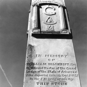
The Fort Smith Confederate Monument is a sculpture erected in 1903 at the Sebastian County Courthouse in Fort Smith (Sebastian County) by the Varina Jefferson Davis Chapter of the United Daughters of the Confederacy (UDC) to commemorate local men who served in the Confederate army during the Civil War and to honor the Confederates buried in Fort Smith National Cemetery. Sebastian County supplied troops for both sides during the Civil War. In the initial months of the war, four infantry companies, a cavalry company, and an artillery battery joined the Arkansas State Troops, and at least five infantry companies and two companies of independent scouts were later raised for Confederate service. Sebastian County residents also enlisted in other Confederate units. U.S. troops …

Fort Smith Museum of History

Since 1910, the Fort Smith Museum of History has acquired, preserved, exhibited, and interpreted objects of historical significance relevant to the founding and growth of Fort Smith (Sebastian County) and the region. Previously known as the Old Commissary Museum and the Old Fort Museum, the current name has identified the museum since 1999. The museum has its beginnings in 1910, when a group of local women learned that the city was planning to tear down its earliest remaining military structure. This building, known as the Old Commissary Building, was a significant historical site. Construction began in 1838, and it was used in various ways by the U.S. Army before being abandoned. It was purchased by the City of Fort Smith …

Fort Smith Regional Airport

The Fort Smith Regional Airport is a mixed-use airport located three miles southeast of Fort Smith (Sebastian County). The airport has two asphalt runways and scheduled commercial aviation to airports in Atlanta, Georgia, and Dallas–Fort Worth, Texas. The initial ideas for an airport date back to the Depression era. In 1939, two sod runways, built on land purchased with a municipal bond authorized in 1936, opened for business. The initial decade saw improvements such as hangars (1941) and paving of the runways (1945). During expansion projects, the two runways were extended from their initial length of 3,500 feet to 8,000 feet for the longer runway and 5,000 feet for the shorter. Construction of the control tower in 1951 permitted greater …

Fort Smith to Jackson Road

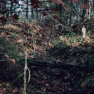
The Fort Smith to Jackson Road was one of several “military roads” the U.S. Congress funded during the 1830s to improve transportation in territorial Arkansas. A Baxter County segment of the road over which the John Benge detachment of Cherokee traveled in 1838 during the Trail of Tears was listed on the National Register of Historic Places on September 22, 2004. On November 1, 1833, the Arkansas Territorial Assembly petitioned Congress to finance a road across northern Arkansas on the grounds that in “an immense extent of country, situated in the upper waters of White River comprising the counties of Lawrence, Izard and Washington, there is no great public road leading through any portion thereof [and the petitioners] would therefore suggest …

Fort Wayne

Fort Wayne was originally built in 1838 near the Arkansas-Oklahoma border for the defense of northwestern Arkansas and the Indian Territory to the west. In 1840, the fort was moved north to a spot about three miles southwest of present-day Maysville (Benton County). Although it was not in Arkansas, Fort Wayne played an important role in Arkansas-Cherokee relations following Indian Removal. After the Cherokee had settled in Indian Territory, political disagreements led to a three-way splintering of the Cherokee people: the Old Settlers who had moved west before the 1835 Treaty of New Echota was signed; the followers of John Ridge, who signed the treaty; and the followers of Chief John Ross, who had opposed the treaty outright. Fort Wayne …

Forts Lookout and Southerland

aka: Forts Southerland and Lookout
aka: Fort Diamond
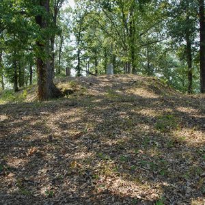
Forts Lookout and Southerland are large earthen redoubts constructed in early 1864 to defend Camden (Ouachita County) from Federal attack during the Civil War. The forts were listed on the National Register of Historic Places on April 19, 1994, and designated as National Historic Landmarks on the same date as components of the Camden Expedition Sites National Historic Landmark. In late 1863, following the September 10 capture of Little Rock (Pulaski County), Lieutenant General Edmund Kirby Smith, Confederate commander of the Trans-Mississippi Department, ordered Lieutenant General Theophilus Holmes to concentrate his forces along the Ouachita River to defend the approaches to Shreveport, Louisiana, against any Union advances to the south. Holmes, in turn, ordered Brigadier General Alexander T. Hawthorn, a …

Forty Days and Forty Nights

Forty Days and Forty Nights is a 2021 novel of the Mississippi River co-written by two veteran storytellers, Amber Edwards and Justin Scott, and published by the University of Louisiana Press. Edwards is best known for the thirteen regional Emmys she won for the State of the Arts series on New Jersey PBS. She has strong Arkansas roots; her mother was born in Mississippi but raised in the Arkansas Delta. In Forty Days and Forty Nights, central character Clementine Price commandeers a volunteer army that fights off a wealthy white supremacist bent on creating a separate white nation called Alluvia in the Mississippi River Delta. Price’s indigenous knowledge of the river helps foil the terrorist attack, preventing America’s second Civil …

Fossils

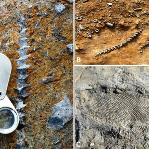
Fossils are the remains of animals and plants that have been preserved in the earth’s crust. They can consist of the remains of invertebrates (animals without a backbone) or vertebrates (animals with a backbone). The majority of fossils in the fossil record, and from Arkansas, are invertebrate remains. Fossils are found mostly in sedimentary rocks, as compared to igneous and metamorphic rocks, and can form in a variety of ways. Animals living in the water column in the ocean die, and their shells or hard parts sink to the bottom of the seafloor and become preserved in sediments that later may lithify, or change to rock. Other animals crawl on the seafloor through sand and silt or burrow into the …

Fouke Monster

Fouke (Miller County) is a small town in southwest Arkansas that attracted attention in the early 1970s when a resident of Texarkana (Miller County) reported being attacked by a mysterious creature there. A reporter for the Texarkana Gazette wrote an article about the events, and from that small publication, a legend was born. Fouke and its monster became famous and were featured in a 1973 movie. In May 1971, Bobby Ford reported to the Fouke constable that he was attacked at his house by a hairy creature that breathed heavily, had red eyes, and moved very fast. Ford said the man-like creature, which was about seven feet tall and three feet across the chest, put its arm around his shoulder …

Fourche La Fave River

The Fourche La Fave River rises in the Ouachita Mountains near Boles (Scott County) and flows east-northeast for approximately 140 miles through Yell County and Perry County before emptying into the Arkansas River south of the town of Fourche (Perry County), which takes its name from the river. It is impounded in Perry County by Nimrod Dam. The origin of the river’s name is open to debate; “fourche” is French for “fork,” and “La Fave” may be in reference either to a family that once lived along the river or to early settler Peter La Fave. The “fork” of the river is the South Fourche La Fave River, which rises in the Ouachita Mountains near Onyx (Yell County) and empties …

Fourche Mountain Salamander

aka: Plethodon fourchensis
The Fourche Mountain salamander (Plethodon fourchensis) is a slender, large (115–178 millimeters in total length) terrestrial salamander that is one of twenty or so members of the caudate family Plethodontidae that can be found in Arkansas. This species is one of three endemic salamanders known to exist in Arkansas and is confined to Fourche Mountain and Irons Fork Mountain in the south-central region of the Ouachita Mountains. Normally, these salamanders can be found beneath the surface rock of hillsides and valleys within these mountains; however, they can also be found under rotting logs on the forest floor. Adults of this species possess two longitudinal rows of large, white blotches on the back; the dorsal body color is, otherwise, uniformly black. …

Fowler Cemetery

The Fowler Cemetery is located approximately two miles east of Damascus, along the southeastern border of Van Buren County. The property is just over an acre and is representative of small, rural family cemeteries found throughout Arkansas. There are eighty-nine marked burials on the grounds. While the cemetery mostly contains members of the Fowler family, there are also individuals from other local families who were related to the Fowlers by marriage. It was listed on the Arkansas Register of Historic Places on August 5, 2020. The Fowlers were one of the many families attracted to the Damascus area in the late nineteenth century, during the cotton farming boom. The family initially settled in the Muddy Bayou area, along the White …

Fowler House

aka: Absalom Fowler House
The Absalom Fowler House, located at 502 East Seventh Street, is one of the few remaining antebellum houses in Little Rock (Pulaski County) in the twenty-first century. Constructed in 1840, it served as a private residence until 1923, when it was sold to the Roman Catholic Diocese of Little Rock. Due to its distinctive Greek Revival–style architecture and unique design, the house was added to the National Register of Historic Places on June 4, 1973. Is also part of the MacArthur Park Historic District. In 1976, the Absalom Fowler House became the centerpiece of the Flower Square apartment complex. The exteriors of both the house and the detached kitchen remain relatively unaltered from their original state. Due to its state …

Franke’s Cafeteria

Franke’s Cafeteria was established by C. A. Franke in Little Rock (Pulaski County) in 1924. It was widely recognized as a culinary institution in the city and was one of the oldest restaurants in Arkansas before its closure in 2020. After leaving the military, C. A. Franke opened a doughnut shop in 1919 on West Capitol Avenue and then a bakery at 111 West 3rd Street in 1922. After determining that bakeries would soon spread and start competing with his own, he sold the bakery to Safeway and switched to the cafeteria business. He opened the first Franke’s Cafeteria in 1924 at 115 West Capitol. Starting in the 1920s, the cafeteria saw four generations of Franke family members take the …

Franklin County Courthouse, Northern District

The Franklin County Courthouse for the Northern District, located at 211 West Commercial in Ozark (Franklin County), was constructed as a two-story structure fashioned in Classical Moderne style with Italian Renaissance design influences. This building is the fourth courthouse in this county seat. Franklin County emerged from part of Crawford County late in 1837. Ozark was designated as the county seat in 1838, and the first court proceedings were held in a school house without windows. The first building designated as a courthouse was built in 1840 on the northwestern corner of the square. This one-story, frame building, which measured twenty square feet, included fifteen windows, one door, and a stove. D. L. Bourland, the county treasurer, submitted the $400 bid for …

Franklin County Courthouse, Southern District

The Franklin County Courthouse for the Southern District, located at 607 East Main Street in Charleston (Franklin County), was constructed as a two-story structure fashioned in Classical Revival Style. Franklin County emerged from part of Crawford County late in 1837. Between 1838 and 1885, Ozark (Franklin County) was the only county seat. Due to difficulty people faced in crossing the Arkansas River, Governor Simon P. Hughes approved an act on March 14, 1885, that created two court districts within Franklin County. The court in Ozark became the Northern District, and Charleston was designated as the county seat for the Southern District in 1901. The Arkansas River drew the boundary line between districts. In June 1885, the sheriff of Franklin County obtained a two-story …

Freedom Centers, Houses, Schools, and Libraries
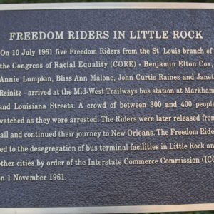
While operating in Arkansas, the Student Nonviolent Coordinating Committee (SNCC) established numerous Freedom Centers, Freedom Houses, Freedom Schools, and Freedom Libraries to foster knowledge and self-respect among African Americans. Freedom Houses were living quarters, administrative workspaces, and community meeting spaces for SNCC volunteers and others. Freedom Centers included Freedom Libraries and Freedom School spaces. Freedom Schools were also established in churches, homes, and businesses to counteract unconstitutional educational facilities and a lack of self-awareness and self-acceptance in the African American community. In October 1962, a new branch of SNCC was established in Little Rock (Pulaski County) with the intention of harnessing the rising tide of Black political consciousness in the South. The branch leader, William (Bill) Hansen, arrived in Little …

Freedom Suits

In the freedom lawsuits initiated before the Civil War, enslaved people brought suit against enslavers, claiming they were entitled to their freedom. The legal basis for the freedom suits varied. Claims were usually based on the enslaved individual having descended from free ancestors or having been the resident of a free state or territory, a situation that could have nullified their enslavement. However, such suits also arose when a group of enslaved people believed their owner had freed them—usually in a will—and they filed suit to ensure the master’s heirs upheld the legal directive. Freedom suits were usually brought by men, but women also undertook such suits on their own behalf, as well as their children’s, given that the legal …

Frenchman’s Mountain Methodist Episcopal Church and Cemetery

aka: Cato United Methodist Church and Cemetery
Frenchman’s Mountain Methodist Episcopal Church, South, located at 13915 Frenchman Mountain Road in the Cato community on the Pulaski–Faulkner County line, is an 1880 wood-frame building altered to its current appearance in 1945. The church and its associated cemetery were listed on the National Register of Historic Places on October 22, 1976. The Frenchman Mountain Methodist Episcopal Church, South, was organized in 1872, with the Reverend R. L. Kirkman ministering to the congregation’s needs, in addition to those of another dozen churches. A log structure was erected in the winter of 1872–1873 to serve as a church, with Kirkman preaching in it for the first time that spring. The Little Rock and Fort Smith Railroad company donated the land on …

Freshwater Drum

aka: Grunter
aka: Gaspergou
The freshwater drum (Aplodinotus grunniens) belongs to the order Perciformes and family Sciaenidae; it is the only freshwater member of the family. Freshwater drum are endemic to freshwater environs of the Americas, and their distributional range extends as far north as the Hudson Bay of Canada and reaches as far south as the Usumacinta River Basin of Guatemala. In the United States, eastward distribution includes the eastern Appalachians westward as far as Kansas, Oklahoma, and Texas. This fish appears to have the greatest latitudinal range of any freshwater fish in North America. In Arkansas, A. grunniens occurs throughout the state but mainly is found in the larger lakes and rivers. The closest living relatives of A. grunniens are a group …