
501-918-3025
calsfoundation@cals.org
calsfoundation@cals.org
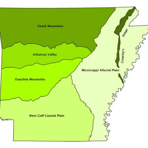
The Gulf Coastal Plain is an area of relatively gently sloping terrain extending across the southern portion of the United States from Texas to Georgia. It was covered by the waters of the Gulf of Mexico until about 50 million years ago. The land rose during periods of tectonic uplift, and water in the Gulf of Mexico retreated to near its present position. Because it was covered by the waters of the Gulf of Mexico for much of its history, the geologic terrain of the Coastal Plain is flat to rolling. Its bedrock is deeply covered with sediment, and the surface has extensive deposits of sand and gravel.
The western portion of the Gulf Coastal Plain—the West Gulf Coastal Plain—extends across southern Arkansas. It is located south of the Ouachita Mountains and extends southward to the Gulf of Mexico and eastward to the Mississippi Alluvial Plain. The boundary between the Ouachita Mountains and the Coastal Plain is marked by rapids and waterfalls at points where streams leave the steeply sloping mountains. The term “fall line” has been used to describe this boundary where the more recent deposits of the plain meet the older, more resistant rocks of the Ouachita Mountains. The eastern boundary of the West Gulf Coastal Plain is the Arkansas River as it extends from Little Rock (Pulaski County) to Pine Bluff (Jefferson County), and then Bayou Bartholomew from Pine Bluff to the Louisiana border. These two waterways separate the West Gulf Coastal Plain from the relatively recent stream deposits of the Mississippi Alluvial Plain.
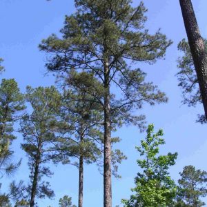
The West Gulf Coastal Plain has several distinctive features, including extensive areas of loblolly-shortleaf pine forests; level to rolling terrain; deposits of sand and gravel; and industrially significant deposits of clay, bauxite, and petroleum. Despite its gently sloping terrain and areas of relatively rich soil, it is a region dominated by forests and forestry-related activities rather than by agriculture. Both pine and hardwood products are harvested in this region where the forest industry is particularly significant. Agricultural activities are limited to pastureland, truck farming, and limited row crops within narrow fertile valleys adjacent to the major streams flowing through the region.
Surface deposits in the Coastal Plain are of ocean origin and date back some 135 million years. Generally, surface materials of the region are poorly consolidated sand and clay with scattered deposits of lignite and small amounts of quartzite and limestone. Bauxite deposits are found in Pulaski and Saline counties in the surface material, with oil and natural gas deposits located farther south in older and deeper formations below the Coastal Plain surface. Industrially significant deposits of clay exist near the surface. These deposits are particularly important to brick companies in Hot Spring, Hempstead, and Miller counties.
Forested Coastal Plain soils predominate in the region except along streams where bottomland and terrace soils are found. Soils are generally deep and made up of a mixture of sand, silt, and clay. These soils are reddish, yellowish, or brownish in color. Interestingly, some Coastal Plain soils in western Arkansas are prairie soils and have scattered prairie grasses.
The natural vegetation of the Gulf Coastal Plain consists of a mixed forest cover. The most extensive tree type in the region by far is the loblolly-shortleaf pine, usually found in combination with numerous hardwood types. Various mixtures of hardwoods are present throughout the southern part of the state. Bottomland hardwood forests are common along and near streams. The oak-hickory-gum type occupies the best-drained sites, with the willow-oak type occupying flat, poorly drained soils.
This region, with its rolling topography and extensive areas of forest, provides more than fifty percent of the state’s total wood production. Land use is dominated by the forest industry with timber companies owning large tracts of land, totaling approximately 2.6 million acres in the Coastal Plain alone, with forests occupying seventy percent or more of the land area of most counties within the region. More than 120 wood-related industries employ thousands of people and provide a tremendous boost to this region’s economy, though the economic downturn and housing slump that began in 2007 have taken their toll on the timber industry.
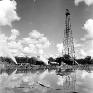
Crude-oil resources were discovered in the early 1920s in the southern part of the West Gulf Coastal Plain. The first Arkansas well to yield sufficient quantities of oil was the Hunter No. 1 that was drilled east of Stephens (Ouachita County) in April 1920. A short time later, other more productive wells were dug, and the historic southern Arkansas oil boom began on January 10, 1921, with the completion of the Busey No. 1 well. Ten counties—Ashley, Union, Ouachita, Columbia, Nevada, Hempstead, Bradley, Calhoun, Lafayette, and Miller—produce oil. Historically, most of the oil production has been in Union, Lafayette, Columbia, and Ouachita counties; these four counties have been responsible for more than eighty-five percent of the oil production in Arkansas. In total, oil companies in the region produce approximately 20 million barrels of crude oil per year, worth billions of dollars.
Exhibits at the Arkansas Museum of Natural Resources at Smackover (Union County) illustrate the various layers of rock and oil deposits in the area and highlight the importance of oil as a resource. The current interest in the possibility of recovering oil trapped in limestone some 10,000 feet below the surface has resulted in the filing of numerous oil leases, particularly in the area between El Dorado (Union County) and Magnolia (Columbia County). Indications are that these deeper deposits of oil (some 2,000 feet below existing deposits) can be tapped by fracturing rock, similar to the method used to extract natural gas in the Fayetteville Shale. Since one test well pumped only forty-five barrels per day, it remains to be seen whether or not the finds will bring an even greater “oil boom” to the area.
The West Gulf Coastal Plain is the location of a unique state park, the Crater of Diamonds State Park near Murfreesboro (Pike County). Located near the boundary between the West Gulf Coastal Plain and the Ouachita Mountains, this park has the only known crater of diamonds in the United States and attracts thousands of visitors each year. The largest diamond ever found at this site since the park was established in 1972 measures 16.37 carats. The diamond, valued at approximately $100,000, was discovered in 1975. More recently, an 8.66 carat diamond was found in April 2011. This gem is the third-largest ever recorded at the Crater of Diamonds State Park.
The West Gulf Coastal Plain, not noted for its large population centers, has some of the most sparsely populated counties in the state. Many county seats have a total population of less than 2,000. Lewisville (Lafayette County) is a good example, with a total population of only 915 in the 2020 census. Calhoun County, with a population of only 4,739, had the lowest county population total in the entire state at the time of the 2020 census. Even one of the largest cities in the region, El Dorado, the county seat of Union County, had a total population of only 17,756 in 2020.
For additional information:
Arkansas Department of Planning. Arkansas Natural Area Planning. Little Rock: State of Arkansas, 1974.
Stroud, Hubert B., and Gerald T. Hanson. Arkansas Geography: The Physical Landscape and the Historical-Cultural Setting. Little Rock: Rose Publishing Company, 1981.
Hubert B. Stroud
Arkansas State University


Comments
No comments on this entry yet.