
501-918-3025
calsfoundation@cals.org
calsfoundation@cals.org
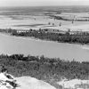
Cadron Creek flows seventy-five miles through central Arkansas. The creek’s headwaters are at Badders Creek, near the old Cherokee Boundary Line. The stream moves southwest through Cleburne County and Van Buren County, as well as through the northwestern corner of Faulkner County. It then meanders south, making up the boundary between Faulkner and Conway County, before flowing into the Arkansas River near Cadron Settlement. The creek also has two distinct forks: the fifteen-mile-long west fork from Cleburne County to Van Buren County and the fifty-mile-long east fork from White County to the main Cadron Creek near the Faulkner-Conway county line.
Speculation on the origins of the name Cadron include it being derived from Kidron Valley in Jerusalem, representing English settlers’ misunderstanding of the French word “quatre,” or taken from the name of Captain Charles Cadron of St. Phillipe by traders sent to the Arkansas River in 1762.
One of the earliest explorers of Cadron Creek was John Standlee in 1778. Moving along the Arkansas River, Standlee marked an area near the creek as his future home and returned in 1811 after exploring more of the country and living in New Madrid, Missouri, for a time. Here, along with his sons, Standlee created Benedict Settlement, later known as Cadron Settlement. This site played an important role in the removal of Native Americans on the Trail of Tears after 1828 and in the completion of the Little Rock and Fort Smith Railroad in 1872.
In 1882, Cadron Creek would have one of the worst floods in its recorded history. Its banks overflowed, engulfing the bottomlands along the creek and pushing far into northwestern Faulkner County. Every farm that was on the Cadron flooded, with the water sweeping away corn and cotton roots, washing away the topsoil, and causing irreparable damage to the farms. The harvest of cotton for the season in Walker Township was almost a total failure, causing many to move away.
From the later 1880s and into the twentieth century, efforts were made to allow for safer and more accessible means of crossing Cadron Creek, especially following the rise in popularity of Pinnacle Springs (Faulkner County), a local hot springs resort that central Arkansans flocked to as a summer vacation spot. This started a trend of hack lines being created across the creek. By 1900, even after the decline of Pinnacle Springs, the building and maintenance of bridges, like the Kings Bridge, across Cadron Creek continued.
Into the 1910s, to combat the flooding issues at Cadron Creek, representatives for improvement districts advocated for the creation of dams on the waterway near Gleason (Faulkner County). While enthusiasm was high at first, the project was abandoned by 1915 and citizens were requesting to dissolve the Cadron Lock and Dam district.
In 1921, the worst flooding of the creek since 1882 occurred, with stagnant water covering the farms on the creek for at least two weeks. Construction efforts would also continue within this decade, with a bridge in Gleason once again being constructed on U.S. Highway 64. Difficulties with flood control would continue well into the 1940s.
In the latter half of the 1900s, water control and projects pertaining to water supply were the main focus of efforts concerning Cadron Creek. In 1954, the city of Conway (Faulkner County) tried to restrict local farmers’ usage of the water supply to irrigate rice and other crops. Ultimately, Conway would lose in favor of equal opportunity usage of water by all landowners of the region.
In the 1970s, controversy arose over the Cadron Creek watershed flooding prevention project due to the perceived inadequacy of the plan and disorganization of efforts. In addition to Representative Edwin Ruthvin (Ed) Bethune Jr. and Governor Bill Clinton, many locals opposed the $16 million fourteen-dam project as a misallocation of funds, and the project was abandoned.
In the twenty-first century, Cadron Creek is a popular destination for floating, kayaking, and canoeing, with the most popular route passing by the ghost town of Pinnacle Springs.
For additional information:
“37th Anniversary of Faulkner County Occurs Today, April 12.” Log Cabin Democrat, April 12, 1910, p. 4.
“Arkansas Industries.” Jonesboro Daily Tribune, April 2, 1929, p. 8.
“Bethune Criticizes Cadron Project.” Batesville Guard, June 15, 1979, p. 4.
“Condray Drafting Good Road Bills.” Log Cabin Democrat, January 21, 1915, p. 1.
“Faulkner County.” Arkansas Democrat, June 3, 1882, p. 3.
Glover, Jimmy. “Pinnacle Springs.” Faulkner Facts and Fiddlings 7, no. 2 (1965): 21–27.
“Group of Conway Citizens Scrambling to Oppose Proposed Watershed Project.” Batesville Guard, October 2, 1978, p. 7.
“Here and There in Arkansas.” Hope Star, October 6, 1947, p. 18.
Junas, Lil. Cadron Creek: A Photographic Narrative. Little Rock: Ozark Society Foundation, 1979.
“Local Notes.” Log Cabin Democrat, July 17, 1900, p. 3.
“Quitman.” Log Cabin Democrat, May 5, 1921, p. 2.
“Rules Conway Can’t Restrict Creek Water.” Hope Star, October 23, 1954, p. 12.
“Sixty Thousand Acres to Be Reclaimed.” Arkansas Democrat, June 28, 1911, p. 1.
“Terrible Rains.” Eureka Springs Republican, June 1, 1882, p. 4.
William G. Coleman Papers, MSS.08.28. Butler Center for Arkansas Studies. Central Arkansas Library System, Little Rock, Arkansas. Finding aid online at https://arstudies.contentdm.oclc.org/digital/search/searchterm/MSS.08.28 (accessed November 25, 2025).
Zane Brooks
University of Central Arkansas


Comments
No comments on this entry yet.