 Abernathy Spring
 Cold Spring
 Abernathy Spring
 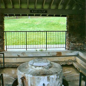 Black Sulfur Spring
 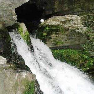 Blanchard Springs Discharge
 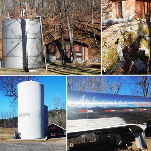 Commercial Springs
  Geothermal Hot Springs
 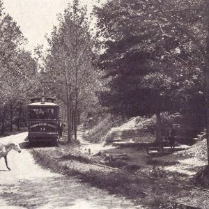 Grotto Springs
 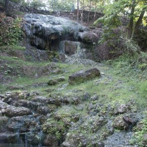 Hot Springs National Park
 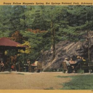 Magnesia Springs
 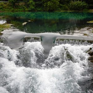 Mammoth Spring
 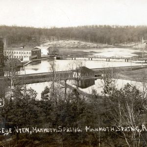 Mammoth Spring
 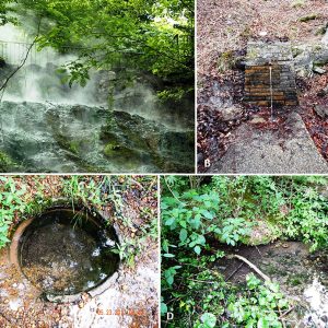 Ouachitas Springs
 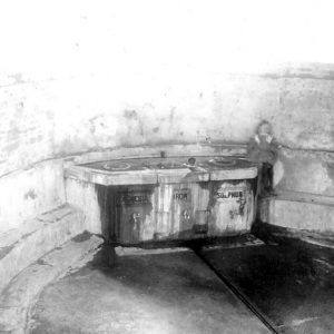 Parnell Springs Spring
 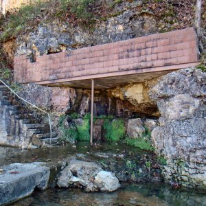 Ravenden Spring
 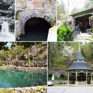 Various Springs
 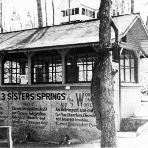 Three Sisters Spring
  Water Troughs
501-918-3025
calsfoundation@cals.org
calsfoundation@cals.org
Springs are naturally occurring geologic features that transport emerging groundwater to the land surface. They also represent a transition from groundwater to surface water. This water can be released through one opening, multiple openings, or numerous seeps in the rock strata or soil. Springs have unique properties such as discrete habitats with relatively constant conditions like temperature, dissolved oxygen concentration, and flow. The underground reservoirs from which springs arise may be cavernicolous limestone, gravel, sand, sediment, soil, or other permeable formations. A spring’s presence depends on the nature and relationship of permeable and impermeable units, the position of the water table, and the land topography. Faults often play an important role in the location of springs by damming up an underground watershed and blocking lateral flow so that the water under hydrostatic pressure can only move upward to overflow as a spring. In other cases, cracking of rock strata has caused the formation of springs.
There are at least three main types of springs: (1) filtration or seepage springs, which refers to springs with small flow rates as the source water has filtered through permeable earth; (2) fracture springs, which discharge from faults, joints, or fissures in the earth and in which springs have followed a natural course of voids or weaknesses in the bedrock; and (3) tubular springs in which the water flows from underground caverns.
Springs are also often classified by the volume of the water they discharge. The largest springs are termed “first-magnitude,” defined as springs that discharge water at a rate of at least 2,800 L or 2.8 m3 (100 ft3) of water per second. Some locations in Florida contain at least twenty-seven known first-magnitude springs, whereas the Missouri and Arkansas Ozarks contain ten known first-magnitude springs.
An unpublished compilation of information on springs in Arkansas collected from approximately 1885 to 1935 provided some information on 296 springs from forty-five of seventy-five counties of the state. Although the vast majority of these are located within the Interior Highlands (Ouachitas and Ozarks), there are at least eighteen springs found in the Gulf Coastal Plain of the state.
In Arkansas, as well as in some other U.S. states, springs have been important from the time of its first peoples. Early Americans almost always made their encampments near water, whether it was a spring or spring-fed stream, or another watershed type. Many skirmishes were fought between the early pioneers, early European settlers, and Native Americans for possession of springs. Furthermore, many springs provided important stops on stagecoach routes; water for medicinal treatment; and power for gristmills, flour mills, sawmills, and cotton gins. In modern times, they are important as municipal water supplies, water for bottling companies, and recreational park features.
The decline of spring flows probably began soon after the first non-native inhabitants came to Arkansas. Undoubtedly, the first effect upon ground water tables and spring flow was the result of deforestation by the early settlers. Deforested land was placed in cultivation or pasture for heavy grazing by cattle and other livestock, which almost certainly reduced recharge. The deep, open structure of the forest soils was altered as the organic matter was consumed and the soils became more impervious. Soon, the soils were so compacted that they could take in only a small portion of the recharge that was formerly transported to the underground reservoir.
Today, major uses of land containing springs in the Ouachitas differ from the major land-uses of those in the Ozarks. Much more of the land in the Ouachitas is managed intensively for timber production on sites owned by either the U.S. Forest Service or private timber companies. Associated with timber production are a variety of troublesome practices, such as clearcutting and large-scale applications of herbicides that can harm springs. Another major use of land in the Ouachitas is mining, which can potentially cause several environmental problems, such as loss of aquatic biota by acid water that can drain into springs and other watersheds and lower the pH level.
No doubt, the drilling of many flowing wells greatly reduced the artesian force on springs. The natural “fountains,” as the springs were described by early explorers, was an indication of the tremendous force with which these springs discharged before they were altered. Heavy well pumping of underground waters for irrigation, municipal, and industrial purposes (more recently, fracking for natural gas) has continued the decline, fouling, and total disappearance of Arkansas springs. Manmade surface reservoirs in the state have also inundated some springs but have increased the flow of others.
Springs are present throughout Arkansas and consist of two general types: perennial and seasonal. Perennial springs flow all year, whereas seasonal or “wet weather” springs dry up periodically, especially during droughts or long periods of negligible rainfall. In Arkansas, these conditions often occur during late summer and early fall. Most of these perennial springs in the state with the largest flows are located in the Ozark Plateau region. Here, springs have historically been important public water sources. Most northern Arkansas communities began abandoning natural springs as water supplies, however, because shallow springs are susceptible to pollutants from the surface. The purity of spring water can vary depending on which part of the state the spring occurs. For example, surface spring water from the Interior Highlands tends to be of higher quality than that from the Gulf Coastal Plain.
Perennial springs also occur in the Ouachita Mountains; most of these are considered “cold,” with temperatures of less than 27°C (80°F). Some of these cold springs are important sources of bottled water. The most famous cold-spring bottling company in Arkansas is Mountain Valley Spring Water Company, which began providing bottled spring water in 1871. The water that flows from Lockett Springs at Mountain Valley just south of Hot Springs Village (Garland and Saline counties) has been slowly filtering into granite-based aquifers for 3,500 years. However, there are areas of hot (geothermal) water springs such as those of Hot Springs National Park, where water temperatures average 62°C (143°F). The hot spring water has been considered for hundreds of years to possess medicinal properties and was a subject of legend among area Native American tribes.
In terms of general spring water temperature (outside of hot springs), groundwater temperature at a depth of 9 m to 18 m (30 to 60 ft) generally exceeds the mean annual air temperature at a given location by 16.4°C (2.5°F). Below these depths, the temperature increases about 16.8°C (1.8°F) for each 30 m (100 ft) of depth. Underground water dissolves minerals from the rocks through which it moves, so its physicochemical quality generally reflects the nature of the rock materials and also the length of time the water has been contained in the rocks.
With an average flow of about 568 m3/min (150,000 gal/min), Mammoth Spring in Fulton County has the largest yield of any spring in the state and is the second-largest spring in the Ozark Mountains behind only Big Spring in Missouri. The spring flows 34 million liters (nine million gal) of water hourly and has had a thirty-five-year daily mean discharge of 358 ft3/sec. The spring forms a scenic ten-acre lake and eventually flows south as the Spring River, a popular Ozark trout-fishing and float stream.
Natural thermal water flows from about forty-seven springs on the western slope of Hot Springs Mountain into Hot Springs Creek at the historic downtown district (Bathhouse Row on Central Avenue) of Hot Springs (Garland County). Over the years, the foremost public use of the springs has been therapeutic bathing. Every day, a total of about 3,800,000 L (1,000,000 gal) of 62°C (143°F) water flows from these springs. Researchers with the National Park Service determined through radiocarbon dating that the water that reaches the surface in Hot Springs (Garland County) fell as rainfall 4,400 years ago. The water percolates very slowly down through the earth’s surface until it reaches superheated areas deep in the crust and then rushes rapidly to the surface to emerge. These hot (“boiling”) springs were first described in 1804–1805 by the expedition party led by William Dunbar (1749–1810), Dr. George Hunter, and a group of soldiers who had been sent by President Thomas Jefferson to describe the springs after the Louisiana Purchase. The valley through which Hot Springs Creek flowed was too narrow for large bathhouses to be built, and by 1883, a rock vault was built over the stream. In addition, the valley was filled to a depth of approximately six meters (20 ft), which created a wide enough level place to build bathhouses. Eight bathhouses were eventually built between 1892 and 1923, but only two were in use for public bathing by 2018. Also, all but two of the original springs have been enclosed, with pipes now carrying their water to a central distribution center.
At least sixty-two springs once flowed from hillsides in the Ozarks in the vicinity of Eureka Springs (Carroll County). Various native cultures long visited the springs for spiritual and healing purposes, and early European settlers also believed that the springs had healing as well as magical powers. Dr. Alvah F. Jackson (1806–1880) was credited with locating the spring and founding Eureka Springs. In 1856, he claimed that the waters of Basin Spring cured his chronic eye ailments. After the Civil War, Jackson marketed the spring waters as “Dr. Jackson’s Eye Water” but made no fortune in it. A few years later in 1879, a friend of Jackson, Judge J. B. Saunders of Berryville (Carroll County), claimed that his crippling skin disease was cured by the spring waters. Saunders started promoting Eureka Springs to friends and family members across the state and created a boomtown. Within a period of little more than one year, the city expanded from a rural spa village to a major town, and developers eventually built a resort community where anyone could drink the pure mountain spring water and soak in spas. Within a short time in the late nineteenth century, Eureka Springs developed as a flourishing city, spa, and tourist destination. Of the original sixty-three springs, more than twelve have been restored. Three of the most notable are Basin Spring, Crescent Spring, and Grotto Spring.
The Ozarks of southern Missouri and northern Arkansas contain some of the best examples of karst features observed anywhere in the United States. Here, a special kind of spring is part of a karst system and is termed a karst spring. It includes the underground drainage of a much larger area, which means that karst springs often have a very large discharge. Karst springs are usually the end of a cave system at the place where a river cave reaches the ground surface. One of the main features of karst springs result from the fact that water is rapidly transported by underground caverns and there is minimal filtering of the water. Many karst springs dry up during the driest part of the year and are thus known as intermittent springs. Still others are dry most of the year and only flow after heavy rain. The properties of karst springs make them unsuitable for the supply of drinking water. Their uneven flow rate does not support steady rates of consumption, especially in summer when there is lower discharge but higher demand. In addition, poor filtering and elevated hardness values imply that the water quality is poor, and therefore karst water is rarely used as drinking water. Two well-known examples of springs of this type are Blanchard Cave Springs in Stone County and Cave Springs Cave in Benton County.
Springs are unique and delicate natural resources, more sensitive to human disturbance than most other watersheds. In the spirit of conservation, several states prohibit wading, swimming, and fishing in springs and spring branches.
For additional information:
Aley, Thomas J. “Groundwater Contamination from Sinkhole Dumps.” Caves and Karst 14 (1972): 17–23.
———. A Predictive Hydrologic Model for Evaluating the Effects of Land Use and Management of the Quantity and Quality of Water from Ozark Springs. Protem, MO: Ozark Underground Laboratory, 1975.
Berry, Trey, Pam Beasley, and Jeanne Clements, eds. The Forgotten Expedition: The Louisiana Purchase Journals of Dunbar and Hunter, 1804–1805. Baton Rouge: Louisiana State University Press, 2006.
Branner, George C. County Mineral Report 2: Mineral Resources of Benton, Carroll, Madison, and Washington Counties. Little Rock: State of Arkansas, Arkansas Geological Survey, 1941.
———. Data of Springs in Arkansas. Little Rock: State of Arkansas, Arkansas Geological Survey, 1937.
———. List of Arkansas Water Wells. Arkansas Geological Survey Information Circular No. 11, 1937.
Branner, J. C. The Mineral Waters of Arkansas, Vol. 1. Arkansas Geological Survey Annual Report for 1892, 1892.
Brune, Gunnar M. Springs of Texas, Vol. 1. 2nd ed. College Station: Texas A&M University Press, 2002.
Elliott, William R. “Zoogeography and Biodiversity of Missouri Caves and Karst.” Journal of Cave and Karst Studies 69 (2007): 135–162.
Howard, J. M., G. W. Colton, and W. L. Prior, eds. Mineral, Fossil-Fuel, and Water Resources of Arkansas. Arkansas Geological Commission Bulletin 24, 1997.
LaMoreaux, Philip E., and Judy T. Tanner, eds. Springs and Bottled Water of the World: Ancient History, Source, Occurrence, Quality and Use. New York: Springer-Verlag, 2001.
Leonard, Ashlon Elizabeth. “Margaret White Springs Recharge Study, Buffalo National River, North-Central Arkansas.” MS thesis, University of Arkansas, 2018. Online at https://scholarworks.uark.edu/etd/3077/ (accessed July 6, 2022).
Schrader, T. “Springs in Ozarks.” U.S. Geological Survey, 2010. On file at Arkansas Geological Survey, Little Rock, Arkansas.
Tresler, Warren. “The Springs of Berryville.” Carroll County Historical Quarterly 65 (Fall 2020): 104–105.
van der Kamp, C. “The Hydrogeology of Springs in Relation to the Biodiversity of Spring Fauna: A Review.” Journal of the Kansas Entomological Society 68 (1995): 4–17.
Chris T. McAllister
Eastern Oklahoma State College


Comments
No comments on this entry yet.