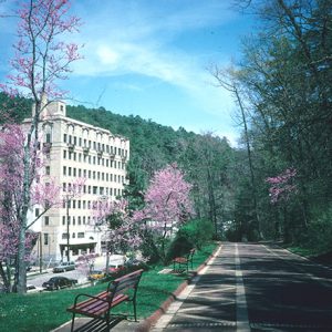
 Park Hotel
Entry Type: Place - Starting with P
Park Hotel
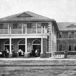 Park Hotel
Parkdale (Ashley County)
One of the oldest incorporated communities in Ashley County, Parkdale (formerly known as Poplar Bluff) has benefited from its location on Bayou Bartholomew and on the Missouri Pacific railroad (now the Union Pacific railroad). Once a busy, prosperous, and even violent city, Parkdale has become a relatively quiet community in the twenty-first century. John Tillman Hughes built a store at the present location of Parkdale in 1857. Some farmers were already working the land near the bayou at that time, including William Morris, John Harris, and William Butler. Morris’s son, John William Morris, worked as a clerk in Hughes’s store and later opened his own store. A Methodist church had also been built in the area sometime in the 1850s. The …
 Parkdale General Store
 Parker Pioneer Homestead
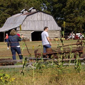
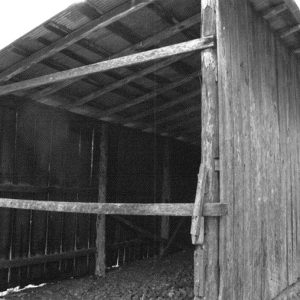
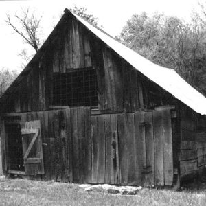 Parker-Hickman Farm Barn
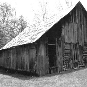 Parker-Hickman Farm Barn
Parker-Hickman Farm Historic District
The Parker-Hickman Farm Historic District is located four miles north of Jasper (Newton County) and was listed on the National Register of Historic Places on August 11, 1987. It encompasses 195 acres and over a dozen buildings related to farming. Eight structures built from the 1850s to 1955 arranged roughly in a rectangle make up the intact farmstead. This exemplary cluster of barns, sheds, smokehouse, privy, and house represents a cross-section and range of rural vernacular architecture in the original location. The farmstead, which has remained in good condition, has been continuously occupied and maintained since the 1850s. Each of the eight farmstead structures was crafted of timber harvested locally using Appalachian-style design elements. These architectural elements include rough-sawn timber …
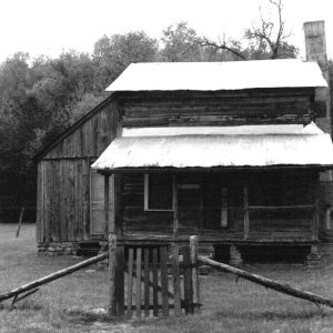 Parker-Hickman Farm House
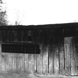 Parker-Hickman Farm Outbuilding
 Parker-Hickman Farm Outbuilding
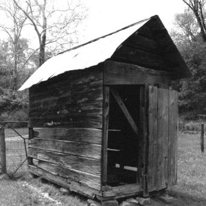 Parker-Hickman Farm Outbuilding
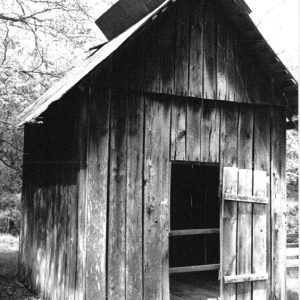 Parker-Hickman Farm Outbuilding
Parkin (Cross County)
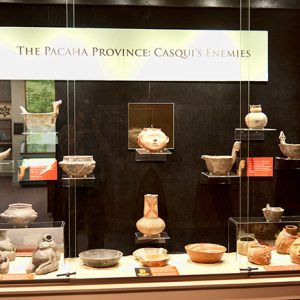
Parkin of Cross County is located on the east side of the St. Francis River in the heart of the Delta, the mainstay of Arkansas’s agricultural industry. At the turn of the century, Parkin was one of the richest and most flourishing towns in this region. Gradually, through the twentieth century, the town has slowly diminished as industry has left it. Parkin can date its recorded history to the sixteenth century. In 1541, Hernando de Soto’s expedition came through northeast Arkansas and camped with a tribe known as the Casqui. The tribe’s village was located in what is now Parkin. Today, Parkin’s main attraction is the preservation of the Casqui mound at Parkin Archeological State Park. Little is known about …
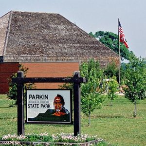
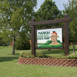
Parkin Archeological State Park
Parkin Archeological State Park in northeast Arkansas preserves and interprets a Mississippian-period Native American village that existed from approximately AD 1000 to 1550. European-made trade items from the era of Hernando de Soto’s expedition recovered at the park and written descriptions of the village support theories that the Spanish visited the Parkin Site in 1541. Many archeologists believe the site may be Casqui, mentioned prominently in the de Soto journals. Remnants of Indian villages similar to the Parkin Site were once numerous in eastern Arkansas, but soil erosion, careless digging, and farming destroyed virtually all of them during the nineteenth century. The prehistoric village on the eastern bank of the St. Francis River covered about seventeen acres and was enclosed …
 Parkin Archeological State Park
 Parkin Archeological State Park
 Parkin Archeological State Park
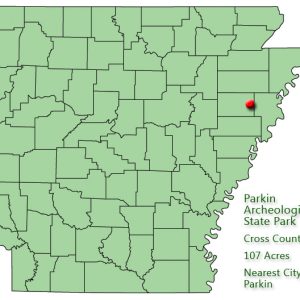 Parkin Archeological State Park: Park Location
 Parkin Baptist Church
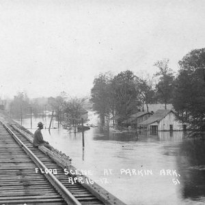 Parkin Flood
Parkin Historic Site
The Parkin Historic Site is a seventeen-acre Native American village site along the St. Francis River in Cross County. Archaeological and geographical information indicates that it is probably the location of the town of Casqui mentioned in the narratives of the Hernando de Soto expedition, which passed through northeast Arkansas in the summer of 1541. In recognition of its national significance, the Parkin site was designated a National Historic Landmark in 1964 and has been on the National Register of Historic Places since 1966. The site is at the north end of Parkin and is the main focus of Parkin Archeological State Park. The Arkansas Archeological Survey established a research station at the site in 1990, and research on the …
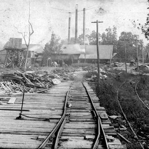 Parkin Mill
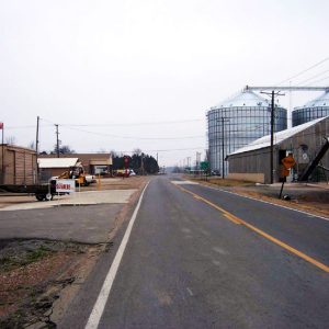
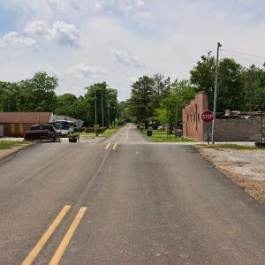 Parkin Street Scene
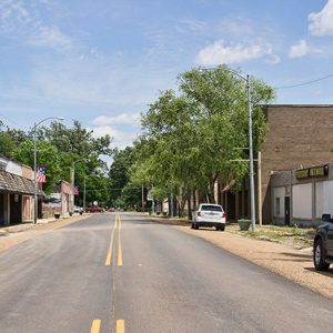 Parkin Street Scene
Parks (Scott County)
Parks is an unincorporated community located along Highway 28 twelve miles southeast of Waldron (Scott County) in eastern Scott County. Originally known as White Church, it was established in 1838 along the Fourche La Fave River as an agricultural community. The earliest people inhabited the area during the Archaic, Woodland, and Mississippian periods. Later inhabitants include Native American people of the Caddo tribe. Several thousand archaeological sites are located throughout the Fourche La Fave River valley, including small burial mounds. During the late seventeenth and early eighteenth centuries, French hunters and tradesmen explored various portions of western Arkansas. These Frenchmen traversed rivers and streams throughout the region, including the Poteau, Petit Jean, and Fourche La Fave rivers. It is probable …
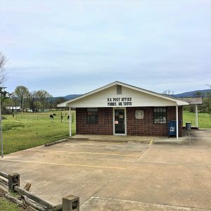 Parks Post Office
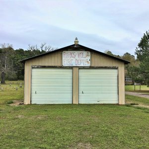 Parks Volunteer Fire Department
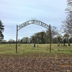 Parks Cemetery
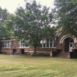 Parks School House - Front
 Parks School House - Rear
 Parks-Cryer House
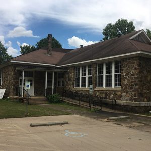
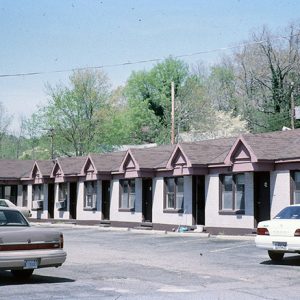
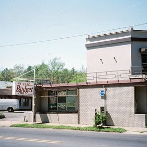
Parkway Courts Historic District
The Parkway Courts Historic District is a motel and apartment complex located at 815 Park Avenue in Hot Springs (Garland County) originally constructed in 1943. Part of the district was rebuilt in the early 1950s after a fire, and it was added to the National Register of Historic Places on February 11, 2004. Businesses began to appear along Park Avenue in the 1930s to serve the tourists who visited Hot Springs. Construction of motels, restaurants, and similar enterprises continued in the area until the 1950s. The Parkway Courts were constructed by Florence Franklin Newell in 1943. She sold the property to Otto Baker in 1950, and the name of the business was changed to Parkway Apartments. Two years later, the …
 Parkway Courts Historic District
 Parkway Courts Historic District
 Parnell Hall
Parnell Springs (Bradley County)
Parnell Springs was located ten miles northwest of Warren (Bradley County) and seven miles south of New Edinburg (Cleveland County), two miles off Highway 8 on a gravel road. It was a booming health resort noted for the healing qualities of its three springs, especially between 1880 and the 1920s. The exact date of the Parnell Springs’ founding in Bradley County is not known, but by 1880, it was both a community and health resort. The community took its name from Joseph M. Parnell, who was the first to capitalize on the water and resort area. In the mid-nineteenth century, many Parnells and their relatives populated the area, including Anna Moseley Parnell, who emigrated from Alabama during the 1840s and …
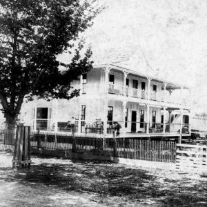 Parnell Springs Hotel
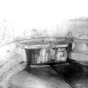 Parnell Springs Spring
Paroquet (Independence County)
Paroquet, located near Newark (Independence County) and the Black River, was named for a now extinct American bird, the Carolina parakeet (Conuropsis carolinensis), which had been found in dense forests, along rivers, and in swamps in North America and especially in Florida and the Carolinas. (Paroquet is an older spelling of “parakeet.”) The Carolina parakeet was also plentiful in parts of Arkansas in the early 1800s and most likely inhabited the swampy regions along the Black River. The species was declared extinct in 1939. Paroquet is located at the intersection of Paroquet Road (Sandman Lane) and Duck Puddle Road approximately five miles east-southeast of Newark and about three miles north-northwest of Jacksonport (Jackson County), the location of the confluence of …
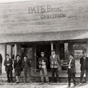 Pate Bros. Groceries
Patmos (Hempstead County)
Patmos is a town in southern Hempstead County on State Highway 355. The town was created by construction of the Louisiana and Arkansas Railway early in the twentieth century, but its most significant years have been in the twenty-first century. Caddo lived and traveled along the Red River not far from Patmos, but no settlement was established in the area at that time. After the Arkansas Territory was established, a network of routes called the Southwest Trail was built across the territory, terminating at Fulton (Hempstead County) on the Red River. Washington (Hempstead County) and other communities were established and grew during these years, but the site of Patmos remained unsettled. Just before the start of the Civil War, in …
Patterson (Woodruff County)
Patterson, located in the southwestern part of Woodruff County, was once an important shipping point for the lumber industry. Today, its economy relies on agricultural services and granaries. Patterson, like many other settlements, was not always called by that name. It began when the B&B Railroad tracks were built across the Missouri Pacific tracks in the 1880s. Rufus Martin was the construction engineer on the project, and the place where the tracks crossed was named Martin’s Junction. Sanders Sawmill on the Cache River floated logs down the river to Martin’s Junction for shipping. Several other sawmills in the area, as well as a stave mill, used the point for shipping, and businesses began to spring up. At some point, the …
 Patterson Street Scene
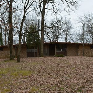 Patteson House
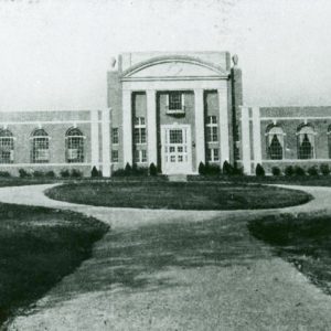
Paul Laurence Dunbar High School
aka: Dunbar Junior and Senior High School and Junior College
Dunbar Junior and Senior High School and Junior College, located at the corner of Wright Avenue and Ringo Street in Little Rock (Pulaski County), is significant in four areas: African American history, education history, legal history, and architecture/engineering achievement. From 1929 to 1955, Dunbar offered a comprehensive education for Black students in Little Rock. The building was added to the National Register of Historic Places in 1980. Nearby residential properties comprise the Paul Laurence Dunbar High School Neighborhood Historic District. Known historically as a Rosenwald School and funded in part by Jewish philanthropist Julius Rosenwald—president of Sears, Roebuck and Company—Dunbar Junior and Senior High School and Junior College was completed in 1929 as the Negro School of Industrial Arts. It …
Paul Laurence Dunbar School Neighborhood Historic District
Dotted with homes dating to the 1890s, the Paul Laurence Dunbar School Neighborhood Historic District in downtown Little Rock (Pulaski County) has been described by the Arkansas Historic Preservation Program as “reflecting the varied architectural styles prevalent during the late-nineteenth and early-to-mid-twentieth centuries, exhibiting a broad mix of influences and architectural variants popular during the period.” The district is nestled between the Governor’s Mansion Historic District to the east and the Central High School Neighborhood Historic District to the west. Paul Laurence Dunbar Junior and Senior High School and Junior College, from which the historic district takes its name, was erected in 1929. “The elaborate Art Deco school is undoubtedly the architectural showcase of the neighborhood,” noted the Paul Laurence …
Pea Ridge (Benton County)
The influx of white settlers into the Pea Ridge area of Arkansas began during the decade prior to Arkansas statehood in 1836 and continued through the 1850s. Pea Ridge became one of the earlier college towns in Arkansas, offering business instruction, music education, and training teachers for early northwest Arkansas schools. Pea Ridge National Military Park, occupying the site of the 1862 Civil War Battle of Pea Ridge, is a major Arkansas tourist attraction. As part of the rapidly expanding economy of northwest Arkansas, Pea Ridge is poised for significant growth during the first decade of the twenty-first century. In fact, the city motto is “Anchored to the Past… Rising to the Future.” Louisiana Purchase through Early Statehood Pea Ridge …
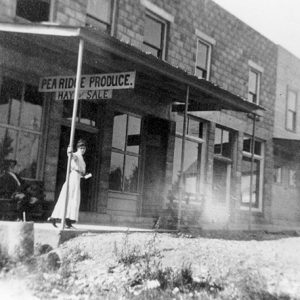 Pea Ridge Produce
Pea Ridge Academy
aka: Mount Vernon Normal College
aka: Mount Vernon Masonic College
aka: Pea Ridge Normal College
The Pea Ridge Academy, organized in 1874, was one of the earliest enduring institutions of higher education in the developing northwest Arkansas area following the Civil War. Contemporary with what is now the University of Arkansas (UA) in Fayetteville (Washington County) and the older Cane Hill College, the Pea Ridge Academy played a significant role in advancing education in Benton County. Organized as a private (or subscription) school, the academy soon entered a cooperative venture with the newly developing public school system, providing space for the public elementary and high school grades, while continuing to operate as a private trustee-governed academy offering college-level courses. Though never a large school, it sent out numerous graduates as business leaders and teachers for …


