501-918-3025
calsfoundation@cals.org
calsfoundation@cals.org
Sharing the same name as the better-known stream in western and central Arkansas that feeds into the Ouachita River, the Saline River in southwestern Arkansas is a tributary of the Little River. A dam on the river in Howard and Sevier counties forms Dierks Lake, and the river also flows into Millwood Lake, along with the Little River. Another dam on the river creates Shady Lake in Polk County.
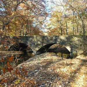
The headwaters of the Saline River are located in Polk County, about seven miles north of Umpire (Howard County). Flowing to the south, the river is dammed at Shady Lake Dam, created by the Civilian Conservation Corps (CCC) in 1937. The buildings around the lake, also constructed by the CCC, are part of the Shady Lake Recreation Area Historic District on the National Register of Historic Places. The lake is located in the Ouachita National Forest. Continuing to the southeast, the river crosses Arkansas Highway 246 and, less than one mile later, Arkansas Highway 84, just west of Athens (Howard County). Multiple county roads cross the river.
Joined by Brushy Creek, the river crosses U.S. Highway 278 about five miles south of Umpire. Flowing to the west, the river enters Dierks Lake, a popular recreation site located about five miles northwest of Dierks (Howard County). The reservoir is impounded by an earthen dam completed in 1975 and covers more than 1,300 acres. As the river departs the lake, it flows southward, crossing U.S. Highway 70, just west of Atwood (Howard County). Additional streams join the Saline as it moves south and crosses U.S. Highway 371 just west of its junction with Arkansas Highway 26, about twelve miles west of Nashville (Howard County).
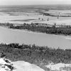
Continuing southward, the Saline crosses Arkansas Highway 27, about five miles southwest of Mineral Springs (Howard County). Flowing southeast, the stream enters Millwood Lake about four miles later. The lake was created in the 1960s, with the dam dedicated in 1966. Before the creation of the reservoir, the Saline joined the Little River. The stream that emerges from the lake is the Little River, which joins the Red River near Fulton (Hempstead County) less than ten miles later.
The river crosses multiple roads and highways but does not pass directly through any towns. The land drained by the river and its tributaries is agricultural and sparsely populated. Timber grown in the watershed of the river is the major crop in the area, along with poultry and cattle operations. Numerous recreational activities occur on the river, most notably at Shady Lake and Millwood Lake. Hiking trails cross the river in the Ouachita National Forest. The river extends for approximately eighty miles.
For additional information:
Saline River Water Data. U.S. Geological Survey. https://waterdata.usgs.gov/monitoring-location/07341000/#parameterCode=00065&period=P7D&showMedian=false (accessed February 6, 2025).
Saucier, Roger T. “The Physical Setting of the Ouachita, Saline, and Little Missouri Rivers, Southern Arkansas.” Arkansas Archeologist: Bulletin of the Arkansas Archeological Society 25–26 (1984–1985): 63–74.
Shady Lake. Ouachita National Forest. https://www.fs.usda.gov/recarea/ouachita/recarea/?recid=10789 (accessed February 6, 2025).
“Shady Lake Recreation Area Historic District.” National Register of Historic Places registration form. On file at Arkansas Historic Preservation Program, Little Rock, Arkansas. Online at https://www.arkansasheritage.com/docs/default-source/national-registry/pl0296_nr-pdf.pdf?sfvrsn=b0ebb35c_0 (accessed February 6, 2025).
David Sesser
Southeastern Louisiana University


Comments
No comments on this entry yet.