501-918-3025
calsfoundation@cals.org
calsfoundation@cals.org
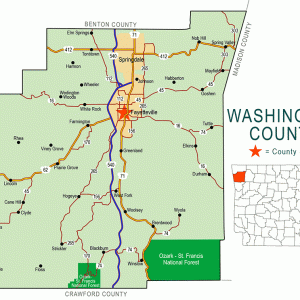
Mount Comfort is a historical community located near Fayetteville (Washington County). The local citizens helped to make the area a center of education, including the establishment of what is now the University of Arkansas (UA).
With the 1803 Louisiana Purchase by the United States, lands opened to additional white settlement and the U.S. government signaled limited interest in maintaining partnerships with Native American peoples. In the Arkansas Territory, hostilities between the Osage, the Cherokee, and the white settlers grew. By 1816, to reduce hostilities, Major William Lovely purchased a tract of land as buffer between the Osage and Cherokee. The Lovely purchase—originally composed of Washington, Benton, and parts of Madison and Carroll counties—eventually became Washington and Benton counties. A slow migration of the Osage to Three Forks (in present-day Oklahoma) and the Cherokee into Arkansas Territory began. Conflict between the tribes continued until yet another treaty was signed, this time at Fort Smith (Sebastian County) in August 1822.
Solomon Tuttle, along with his sons, his son-in-law William D. Cunningham, and the family’s enslaved people, settled in 1828 on this land, which stretched along the upland valley and included Clear Creek and Mount Comfort Branch, now known as Hamestring Creek. Other immigrants joined them, and the settlement grew and took the name of Mount Comfort after the church at its core.
By 1835, the county was dotted with the farms, mills, hamlets, blacksmith shops, and other undertakings of white settlers. Native tribes were forcibly moved west until the end of the decade, largely because of the 1835 Treaty of New Echota. Most Cherokee neither signed the treaty nor agreed to the land exchange. Three detachments of Cherokee passed Mount Comfort and parts of present-day Washington County on their way to Oklahoma. The first detachment from Cherokee Agency near Charleston, Tennessee, used the North Route and entered Arkansas at Pea Ridge (Benton County). The second detachment used the old Southwest Trail, stopping in Fayetteville near present-day Fayetteville High School on Stadium Drive and Martin Luther King Boulevard. A third stayed near the Cunningham home in Mount Comfort before departing through Cincinnati (Washington County) and present-day Farmington (Washington County) to Cherokee Nation West.
Despite the bitterness of these forcible movements on what became known as the Trail of Tears, the Cherokee endured. In the end, commerce between the Cherokee Nation and Fayetteville grew out of their proximity, and the families often educated their children in Washington County.
Mount Comfort and Cane Hill (Washington County), both Cumberland Presbyterian communities, fifteen miles apart, were tied through family, clergy, and educational endeavors. Later, the Fayetteville Presbyterian Church and the Mount Comfort Presbyterian Church were established as a result of this tie.
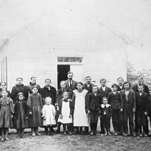
Families from northwestern Arkansas and the Indian Territory were eager to send their sons to Mount Comfort Far West Seminary to study. The seminary burned, however, in 1845 before completion. The Ozark Institute was established by the Reverend Robert Mecklin, who purchased the seminary land and completed the endeavor; within four years, it had enrolled sixty students. (The Mount Comfort Female Academy was also established.) Notable Ozark Institute students included John Rollin Ridge, the first Native American known to have published a novel; James H. Van Hoose, mayor of Fayetteville; Edward Payson Washbourne, painter of the Arkansas Traveler; and John Lynch Adair, editor of the Cherokee Advocate.
The Far West Seminary, Ozark Institute, and Mount Comfort Female Academy (commonly known as Miss James’s after the founding teacher Ann James) were prominent educational forerunners in the Mount Comfort community to the 1871 establishment of what became the University of Arkansas.
Cumberland Presbyterian Church leaders, like many white southern Christians at the time, thought slavery theologically sound and morally just. Slave labor helped construct some homes and other buildings in the Mount Comfort locality.
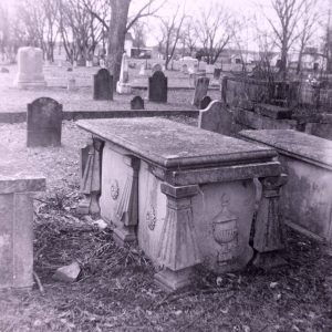
The entire northwestern region, with its proximity to grain and livestock resources, was critical during the Civil War. Mount Comfort, close to major north-south roads, fell to repeated fighting, with the factions fluctuating in dominance. The region remained under Confederate control until February 1862, when the Confederates set Fayetteville ablaze and retreated as Union troops advanced into the area. Mount Comfort, scant miles from Fayetteville, suffered frequent raids and skirmishes beyond Federal control throughout the war. Sometime during this period, the Mount Comfort Church was destroyed. Later oral accounts and records indicate that brick (a premium material) and wood, apparently salvaged from the church, were taken to Fayetteville for Federal fortifications circa 1863.
Oral history suggests that Mount Comfort structures were used to form a hospital during the war. Although a specific building is not indicated, the Ozark Institute, a mile east of the church, was perhaps utilized as a Confederate hospital, appearing to have been operational by January 1862.
A series of letters written in 1863–1864 by Robert Mecklin detailed life around Mount Comfort as a mixture of violence, civil strife, marauders, and frequent turnovers between Union and Confederate armies. By 1864, fields lay fallow, mills burned, and stores ransacked. The Union Post Colony was established December 1864. It provided local farmers with good crop land and defense against marauders. In exchange, residents had to swear allegiance to the Union.
After the Civil War, Mount Comfort slowly declined as people moved into Fayetteville, to Benton County, and on to other states. Improved roads and better opportunities stimulated these moves, and, later, the advent of cars accelerated the population shift.
Three poor farms were established in Washington County, one at Mount Comfort. Federal and state social welfare programs eventually replaced this system.
As population increased in northwestern Arkansas, small rural districts began to consolidate. In 1927, the state passed legislation requiring districts with fewer than fifteen pupils to dissolve and/or combine. By 1949, again through legislation, smaller schools were folded into larger districts. Mount Comfort was among them.
In the twenty-first century, the church, graveyard, and schoolhouse (a meeting site, not a functional school) still stand and serve Washington County residents. Subdivisions, schools, and recreational parks have replaced the original buildings and farms.
For additional information:
Alison, Charles Y. A Brief History of Fayetteville, Arkansas. Charleston, SC: History Press, 2017.
Hartney, Nancy. “Mount Comfort: Marked by Education, Religion, and War.” Flashback 70 (Fall 2020): 118–128.
Hillard, Jerry E. An Antebellum Ozark Community and the Civil War: The Archeology of the Second Mount Comfort Church (3WA880) Washington County, AR (1840–ca. 1865). Research Series No. 63. Fayetteville: Arkansas Archeological Survey, 2008.
Mecklin, Robert W. “The Mecklin Letters Written in 1863–64 at Mount Comfort. Edited by W. J. Lemke. Bulletin Series Number 10. Fayetteville, AR: Washington County Historical Society, 1955.
Nancy Hartney
Fayetteville, Arkansas


We have driven on the Mount Comfort road for three years now, have been in the schoolhouse for events, and my husband has walked the cemetery. We live west on Mount Comfort now so it is nice to read the history.