


501-918-3025
calsfoundation@cals.org
calsfoundation@cals.org
Constructed in 1939 by the Memphis District Corps of Engineers for Drainage District Number Seven of Poinsett County, the Marked Tree Siphons were an integral part of the St. Francis River Basin Flood Control Project. The siphons were also a unique application of an engineering structure of their type, designed to lift the flow of the St. Francis River over an earthen levee and deposit it in the river channel on the other side of the levee.
In 1917, Drainage District Number Seven of Poinsett County was authorized by the Arkansas General Assembly. The St. Francis River meandered from north to south through the district, which encompassed most of the county east of Crowley’s Ridge, and carried a considerable traffic of lumber, log rafts, and boats. In order to regulate flooding, a floodway was designed to divert the overflow. Where the floodway levee crossed the river north of Marked Tree (Poinsett County), a sluiceway would maintain the channel, while a lock would allow river traffic to continue. Because the St. Francis was designated navigable to Wappapello, Missouri, the U.S. Department of War had to approve any changes likely to affect travel or movement of commerce on the river. On January 4, 1924, the department issued a permit for the construction of the sluiceway, lock, and a floodway sill on the condition that the river channel was maintained. The Steep Gut Floodway, the lock, and the sluiceway were completed in 1926.
In 1933, forty feet of the sluiceway broke and dropped to a thirty-degree angle, and a portion of the levee collapsed. Temporary repairs permitted the continued operation of the damaged sluiceway. In 1936, the St. Francis River was included in revisions to the Flood Control Act, and an inspection of the sluiceway by the U.S. Army Corps of Engineers in October revealed the levee had seriously eroded. Flow was stopped, and navigation of sixty-four miles of the river from Marked Tree to Wittsburg (Cross County) was halted.
In December 1937, the Corps of Engineers began repairs to the sluiceway. On May 7, 1938, high waters washed out a ninety-foot gap in the levee. The sluiceway settled further and was damaged beyond repair. By October, the levee break was repaired and the sluiceway removed.
According to the Corps of Engineers, the sluiceway and levee failed because they were constructed on a stratum of fine sands that tended to become “quick” when saturated. Repair or replacement of the sluiceway was deemed too costly, so the Memphis District announced it would permanently dam the levee gap, with the plan that “instead of passing water under or through the dam, water will be siphoned over it.”
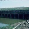
From December 1938 to June 1939, Memphis District engineers designed and installed the Marked Tree Siphons. Constructed in the district shops at a cost of $215,000, the three nine-foot-diameter, 228-foot-long, electronically welded steel tubes were among the largest in the world. Their operation was deceptively simple. First, a vacuum pump primed each siphon. Once the siphon was primed, the vacuum pump was turned off, and the flow was self-sustaining. An air valve regulated the rate of flow.
On June 7, 1939, hundreds of spectators attended the dedication of the siphons. A correspondent for the Marked Tree Tribune incredulously reported: “A whole river was lifted 30 feet across a dam and deposited on the other side.” In his address, district engineer Major Daniel Noce described the siphons as the only ones of their type in the world and as “unique in the annals of engineering.”
Since 1939, the siphons have maintained the St. Francis River in its natural channel, as well as protected agricultural resources and permitted expanding settlement in the area. Tests of the completed siphons revealed an operating efficiency of 97.1 percent, an achievement “not thought to have been achievable under conditions other than those of laboratory models.” On May 2, 1988, the Marked Tree Siphons and the 1924 lock were listed in the National Register of Historic Places. The lock is no longer used, but both lock and siphons, located on Lock and Dam Road northwest of Marked Tree, are accessible to the public.
For additional information:
“Drainage District No. 7, Poinsett County, Arkansas. An Early Report by Pride and Fairley, Blytheville.” On file at Drainage District Number Seven of Poinsett County, Marked Tree, Arkansas.
“Hundreds Gather for Dedication of Huge Siphons Across Dam Near M. Tree.” Marked Tree Tribune, June 8, 1939, p. 1.
“Justification Report, Repair of Marked Tree Siphons: Flood Control, Mississippi River and Tributaries, St. Francis Basin Project.” Memphis: U.S. Army Corps of Engineers, Memphis District, April 1983.
“Marked Tree Lock and Siphons.” National Register of Historic Places nomination form. On file at Arkansas Historic Preservation Program, Little Rock, Arkansas. Online at http://www.arkansaspreservation.com/National-Register-Listings/PDF/PO0018-PO0019.nr.pdf (accessed April 26, 2022).
Mitchell, Steven E. “Marked Tree Lock and Siphons.” National Register of Historic Places Registration Form, 1988. On file at Arkansas Historic Preservation Program, Little Rock, Arkansas.
Steven E. Mitchell
Jefferson City, Missouri


Comments
No comments on this entry yet.