501-918-3025
calsfoundation@cals.org
calsfoundation@cals.org
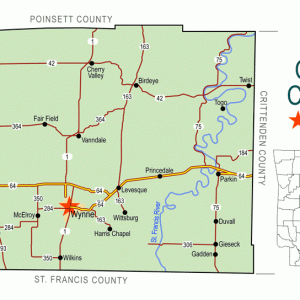
Located on the eastern slope of Crowley’s Ridge in the St. Francis River watershed, Wittsburg developed near the intersection of the roads on Crowley’s Ridge, the St. Francis River, and the Congressional (Military) Road from Memphis, Tennessee, to Little Rock (Pulaski County). Incorporated in 1848, the town functioned as the Cross County seat from 1862 to 1865 and again from 1868 to 1884. Rebounding after the Civil War and surviving a major fire in 1874, the town grew due to the trade in cotton and dry goods. Wittsburg began to fade after being bypassed by two railroad lines in 1882 and 1887 that drew trade to the west side of Crowley’s Ridge and Wynne (Cross County).
European Exploration and Settlement
Due to the elevated highlands of Crowley’s Ridge and the easy access to transportation and sustenance via the St. Francis River valley, Native Americans occupied the general area near Wittsburg. Prior to European settlement, the Wittsburg area fell under the vast territorial claims of a number of Native American groups such as the Casqui at the time of Hernando de Soto’s exploration of Arkansas in 1541 and the Osage and Quapaw around the time of the visit of Louis Joliet and Father Jacques Marquette to the region in 1673. However, no direct evidence of habitation by Native Americans is found at the actual site.
Louisiana Purchase through Early Statehood
As part of the region that would become known as the Louisiana Purchase, the Wittsburg area was owned by the governments of Spain and France, both of which were willing to allow Native Americans and whites access to land to bolster the population. During the mid-1790s, the Spanish granted a band of Cherokee the hunting rights to the St. Francis River valley, and the neighboring Delaware tribe, which was granted rights to the White River valley, may have been one of several groups that traversed and traded in the area as well. When the United States obtained the Louisiana Purchase in 1803, existing land claims, often called “Spanish Grants” due to Spanish ownership of the Louisiana Territory from 1763 to 1800, show that the region already had white settlers scattered in it, and a village of Cherokee was just five miles south of the grant that contained the future site of Wittsburg. A confusing chain of ownership ended for the Wittsburg area, known as Spanish Grant 2379, when William Russell surveyed the area and sold it to William Strong sometime after 1830. Due to the failure of the Arkansas Real Estate Bank, Strong was forced to give up his claim, and Russell took possession of the tract, eventually selling it to Isaac Wofford in 1847.
Strong’s Place, or St. Francis, was the first European settlement developed in Spanish Grant 2379. South of the future site of Wittsburg, it had mail delivery, stores, a tavern, steamboat contact in 1836, and access to Memphis via the Military Road. However, the swampy nature of the Military Road near Strong’s Place made travel difficult at times. As an elevated northern route developed on the Military Road, it bypassed Strong’s Place and aided in the settlement of Wittsburg. While the actual founding date of the town remains unknown, records indicate that a settlement could have been there as early as 1845. The actual name Wittsburg did not occur in any legal documents until 1848 when Ebeneezer Slocum was named as the town’s first postmaster, the same year the town was incorporated.
The geographic location of Wittsburg made it thrive as a regional trade center for cotton transportation and storage, as well as dry goods sales. Due to population growth, a second incorporation was required in 1859 to increase the land holding of the town. By 1860, Wittsburg had grown to 100 people, and various structures and businesses included a dock, cotton warehouses, a post office, a newspaper called the Wittsburg Messenger (originally called the Arkansas Traveler), a grist mill, and a school.
Civil War through Reconstruction
Wittsburg was economically stunted by the Civil War. Two companies were organized to serve the Confederate army as part of the Fifth Arkansas Infantry regiment. In fact, elements of nine Confederate companies were raised in the region, both regular and irregular, taking some 500 men from the Wittsburg vicinity during the conflict. Due to their absence, farms and businesses did not function normally. Additionally, foraging by both military and guerrilla units camping near the region, the freeing of slaves, and the confiscation or destruction of personal property throughout the conflict lessened Wittsburg’s economic vitality.
On November 15, 1862, Wittsburg was named the county seat of the newly created Cross County. Now facing the complications of establishing local county governance, the citizens of Wittsburg also had to cope with new challenges: the disruption in communication and transportation lines by Federal forces’ increasing presence in northeastern Arkansas. Colonel Powell Clayton raided Wittsburg twice in 1863, once during his Helena Expedition on March 5–12, and then again with a larger force on April 7, 1863. In both cases, Clayton’s force confiscated supplies.
Many county businesses secretly relocated to the town of Pineville (Cross County) to avoid Union detection. The longest occupation of Wittsburg occurred under Brigadier General John W. Davidson, who encamped there from July 28 to August 1, 1863. In his time there, he built a small redoubt on the ridge near Wittsburg. Only one skirmish actually occurred in the town. On June 6, 1864, the Third Iowa Cavalry Regiment fought an unknown Confederate force; however, no clear records describing the event have been discovered.
At the end of the war, Wittsburg was one of two major sites for Confederate surrender in northeastern Arkansas, the other being Jacksonport (Jackson County). Approximately 2,100 men were paroled in Wittsburg.
In 1871, an African-American man named Frank Harris was lynched after being accused of murdering a white girl.
Reconstruction through the Gilded Age
For Wittsburg, the Reconstruction era was a mixture of confusion, lawlessness, and economic renewal. Politically, Wittsburg lost the position of county seat to Cleburne, a newly created community, from July 3, 1865 to August 2, 1868, when it was returned. Due to an April 1869 requirement passed by the legislature, all municipalities in Arkansas had to reincorporate. Accordingly, Wittsburg reincorporated for the third time on May 13, 1869. Economically, the town seemed to weather Reconstruction fairly well. By 1866, there were more than ten taxable businesses in Wittsburg as well as a post office and a church. Efforts to improve the road to Memphis were coupled with a return to steamboat contact, thus improving trade. By 1874, the town had a population of 300 people.
Disaster struck on the night of November 6, 1874, when a fire began in the office of the Wittsburg Gazette in the Dodge Trader of Memphis warehouse. The blaze raged for at least two hours and inflicted an estimated $25,000 to $50,000 in damages. While stunted, the trade in timber and furs, as well as the movement of some 30,000 bales of cotton annually, provided the economic stimulus to rebuild the damaged parts of town. A new newspaper developed in 1875, the Wittsburg Phoenix, but closed in 1878. By 1878, the town incorporated for the last time.
The 1880s began a period of decline for Wittsburg. The census revealed that the town had slowly slipped to 209 people by 1880. The north-to-south route of the Helena and Iron Mountain Railroad (later the St. Louis, Iron Mountain and Southern), completed in 1882, passed to the west side of Crowley’s Ridge, thus hurting business in Wittsburg. In 1885, the town’s last newspaper, the Wittsburg Chronicle, which had begun in 1878, moved to Vanndale (Cross County) as the Cross County Chronicle. The east-to-west line of the St. Louis, Iron Mountain and Southern Railroad, from Memphis to Bald Knob (White County), ran to the north of Wittsburg, thus drawing trade to the west side of Crowley’s Ridge where both tracks crossed at Wynne. As Wynne grew, Wittsburg dissolved. By 1900, the post office in Wittsburg closed.
Early Twentieth Century through the Modern Era
While the town has dwindled over time, a small, scattered population still lives in the area. While no main businesses exist on the old town site, the Wittsburg Store and Gas Station, a 1930s–1970s general store for the region, is on the National Register of Historic Places. Agriculture still plays a major part in the economic activity in the region. Wittsburg is the location of the Wittsburg Natural Area (a wildlife management area), which is set aside to protect the flora and fauna of the region and allows limited hunting activities managed by the Arkansas Game and Fish Commission. Due to the historic importance of the region, the town remains a point of interest and pride for residents of Cross County. On June 6, 2012, a commemorative Civil War Sesquicentennial marker was placed there to highlight Wittsburg’s role during the conflict.
For additional information:
Hartness, Richard L., Sr. Wittsburg, Arkansas: Crowley’s Ridge Steamboat Riverport, 1848–1890. Little Rock: Rose Publishing Company, 1979.
———. Wittsburg, Wynne, & Points Nearby…. Conway, AR: Conway Printing Company, 2009.
Derek Allen Clements
Black River Technical College


Comments
No comments on this entry yet.