

501-918-3025
calsfoundation@cals.org
calsfoundation@cals.org
Interstate 30 (often called “I-30”) is a U.S. interstate highway that connects the Little Rock (Pulaski County) metropolitan area in central Arkansas to the Dallas-Fort Worth metropolitan area in northern Texas. The Arkansas portion of Interstate 30 is a southwest-to-northeast mostly diagonal line just over 143 miles long, stretching from Texarkana (Miller County) at the Arkansas-Texas state border to Interstate 40 in North Little Rock (Pulaski County). Since the middle of the twentieth century, Interstate 30 has played a major role in the growth and development of central and southwestern Arkansas.
History
Interstate 30 is one of the original trunk highways that formed the backbone of the U.S. interstate highway system. Along with Interstate 40 and Interstate 55, Interstate 30 was one of only three major Arkansas routes included in the first plan for U.S. interstates in 1955, the so-called yellow book. Interstate 30 is the shortest of all the original primary east-west Interstate Highways that end in a “0” in the entire United States.
In the 1950s, parts of Little Rock’s University Avenue and Interstate 30 were known as the New Benton Highway, a pre-interstate four-lane highway connecting Pulaski County with Saline County. Portions of this divided road became the first stretch of Interstate 30 built in Arkansas. By 1960, the entirety of I-30 in Arkansas consisted of a piece extending from University Avenue in Little Rock to five miles west of Benton, north of Haskell (Saline County). In November 1962, the northern terminus of I-30 was officially completed, when the I-40 and I-30 interchange in North Little Rock (Pulaski County) opened.
Construction of I-30 in Arkansas continued throughout the 1960s, and by the early 1970s, only the portion between Hope (Hempstead County) and Prescott (Nevada County) had not yet been completed. On November 10, 1972, the final segment of this route was dedicated and opened to the public with a ceremony at present-day Exit 36 near Emmet (Nevada and Hempstead counties), signaling the long-awaited connection of Little Rock and Dallas by an interstate highway.
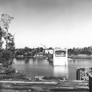
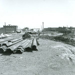
Initially known as the Little Rock Expressway in downtown Little Rock, Interstate 30 increasingly became an important link both to and from central Arkansas. According to 2023 Arkansas Department of Transportation traffic counts, the Interstate 30 bridge over the Arkansas River was the busiest stretch of highway in the entire state. As a result, twenty-first-century Arkansas leaders pushed for an expansion of I-30 in downtown Little Rock and North Little Rock. After Arkansas voters passed Issue 1, the Transportation Sales Tax Continuation Amendment, in 2020, plans were made to create a ten-lane interstate between I-630 and I-40. The first phase of what became known as the “30 Crossing” project created a ten-lane bridge over the Arkansas River. At a price tag of $634 million, the river bridge was completed by December 2024, six months ahead of schedule. Future funded phases of construction include planned improvements to the I-30/I-40 interchange in North Little Rock.
Central Arkansas has seen major suburban county growth since the middle of the twentieth century. In the sixty years from 1900 to 1960, Saline County’s population increased by almost 16,000, while in the sixty years from 1960 to 2020, its population increased by nearly 100,000. The rapid population growth of Saline County can be largely attributed to Interstate 30’s multilane highway access, allowing residents to live in Benton (Saline County) or Bryant (Saline County) but still drive into Little Rock for employment. Using U.S. Census data from the early 2020s, Metroplan found that more Benton and Bryant residents worked in Little Rock than worked in their respective home cities.
Route
Interstate Highways are measured from west to east (or south to north) in each U.S. state. Mile 0 for I-30 in Arkansas is at the Arkansas-Texas border in Texarkana. Also in Texarkana, I-30 connects to the southern Arkansas section of I-49. For more than 100 miles, I-30 follows a mostly diagonal route, with the highlands of the Ouachita Mountains to the west and the lowlands of the Gulf Coastal Plain to the east. This path mirrors previous transportation routes in southwestern Arkansas, as Interstate 30 runs somewhat parallel to U.S. Highway 67, the Union Pacific Railroad, and the old historic Southwest Trail.
Interstate 30 crosses seven counties in Arkansas. Cutting through southwestern Arkansas, the modern Interstate 30 passes through Texarkana, Hope, Prescott, Arkadelphia (Clark County), and Malvern (Hot Spring County). Officially crossing into the Little Rock metro area, the most populated area in the state, I-30 expands to six lanes, three in each direction, as it traverses Benton and Bryant. In Little Rock, Interstate 30 encounters four major interchanges, meeting Interstate 430, Interstate 530, Interstate 440, Interstate 630. Crossing the Arkansas River with the new ten-lane 30 Crossing bridge project, Interstate 30 enters North Little Rock, where it comes to an end at the Interstate 40 interchange, 143 miles after it started.
For additional information:
Arkansas Department of Transportation. “Average Daily Traffic Maps.” http://ardot.gov/divisions/tsmo/traffic-information-systems/maps/ (accessed January 21, 2026).
Arkansas Department of Transportation. “Historic Tourist Maps.” http://ardot.gov/divisions/planning/gis-mapping/arkansas-state-highway-tourist-map/historic-tourist-maps-by-year/ (accessed January 21, 2026).
Arkansas Highway Commission. Arkansas Highways 18, no. 5 (December 1972). Online at https://www.ardot.gov/wp-content/uploads/2021/03/Vol.-18-October-November-December-1972-No.5.pdf (accessed January 21, 2026).
Arkansas Highway and Transportation Department. “Arkansas Road Inventory.” GIS database, hosted at Arkansas GIS Office. Online at https://gis.arkansas.gov/product/arkansas-road-inventory/ (accessed January 21, 2026).
Arkansas Highway and Transportation Department. Historical Review, Volume Two: Arkansas State Highway Commission and Arkansas State Highway and Transportation Department, 1913–2003. Little Rock: Arkansas State Highway and Transportation Department, 2004.
“Commuting Flows for Central Arkansas Cities 2017–2021.” Metroplan.org. https://metroplan.org/wp-content/uploads/2025/08/Commuting-Flows_CitiesandCounties.pdf (accessed January 21, 2026).
McLaren, Christie. Arkansas Highway History and Architecture, 1910–1965. Little Rock: Arkansas Historic Preservation Program, 1999.
McNichol, Dan. The Roads That Built America: The Incredible Story of the U.S. Interstate System. New York: Sterling, 2006.
Strain, Milo. “After 4 Years and $634 million, Little Rock’s I-30 Widening Is Done—At Least This Phase.” Arkansas Times, December 3, 2024. https://arktimes.com/arkansas-blog/2024/12/03/after-4-years-and-634-million-little-rocks-i-30-widening-is-done-at-least-this-phase (accessed January 21, 2026).
Patrick Hagge
Arkansas Tech University


Comments
No comments on this entry yet.