


501-918-3025
calsfoundation@cals.org
calsfoundation@cals.org
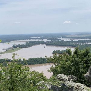
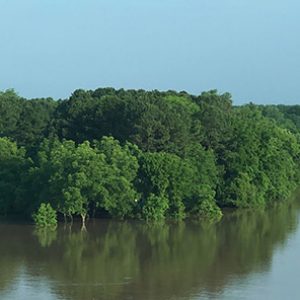
The flood along the Arkansas River that occurred in the spring of 2019 broke a number of high-water records and proved to be one of the costliest natural disasters in the state’s history. In addition, the flood cast light upon the state’s aging levee and transportation infrastructure.
Several climatological factors combined to produce the flood. First, a mild winter and warmer than usual spring (likely exacerbated by global warming) led to early snowmelt in the Rocky Mountains, the source of the Arkansas River. During the spring months, especially in May, the Great Plains were hit by repeated storms that brought record numbers of tornadoes and record rainfall; high pressure over the southeastern states stalled this weather in the Midwest. For example, during one week, parts of Oklahoma received between six and twelve inches of rain. By late May, the Arkansas River’s flood-risk-reduction lakes in Oklahoma had filled, forcing the release of water from those reservoirs. During the same general time period, the Missouri River also experienced catastrophic flooding, for many of the same reasons, and the lower Mississippi River was elevated, worsening the situation.
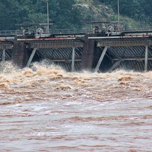
Barge traffic along the river had halted earlier in May due to high water in the Mississippi River. By May 22, the U.S. Army Corps of Engineers warned that the Arkansas River was flowing too fast to be safe for small boats, with Trimble Lock and Dam near Fort Smith (Sebastian County) recording flows of 170,000 cubic feet per second, or 100,000 cubic feet per second above the level at which a small-craft advisory is enacted. The flows soon reached more than 500,000 cubic feet per second across the river. On May 23, two barges broke loose from the Port of Muskogee in Oklahoma and traveled down the river for twenty miles before slamming into the dam at Webbers Falls and sinking the following day. (Although the sight made for some dramatic images, the actual damage to the dam was reported as minimal.)
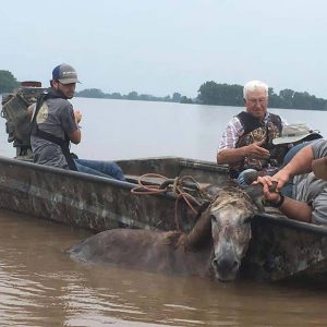
Governor Asa Hutchinson declared a state of emergency on May 24 and sent Arkansas National Guard rescue teams to western Arkansas in advance of the flood cresting there. That same day, the Red Cross opened a shelter in Fort Smith; as the flood continued, other cities began opening their own emergency shelters. By Memorial Day (May 27), the state was experiencing major flooding at all Arkansas River gauges west of Toad Suck Lock and Dam, as well as in Pine Bluff (Jefferson County), while Little Rock (Pulaski County) was recording moderate flooding. High-water records were broken all along the river, including at Morrilton (Conway County), where the record had previously been set during the disastrous Flood of 1927.
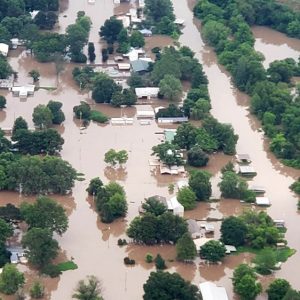
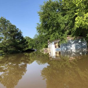
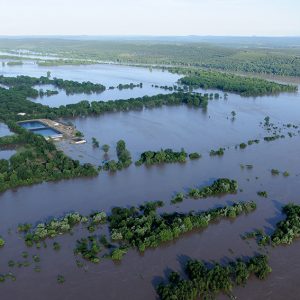
By May 25, 2019, as many as 200 people had evacuated in Fort Smith; about 545 homes in the county were eventually affected. Flooding led to the closure of a number of highways, such as the westbound lanes of U.S. 64 at the Arkansas River bridge in Fort Smith and a section of Arkansas Highway 105 in Pope County early in the flooding; by the end of May, more than two dozen state highways were closed due to high water. As the flooding continued, voluntary and mandatory evacuation orders were issued all along the course of the river. By late May, residents were leaving the Island Harbor Estates neighborhood in Pine Bluff as it became inundated, and 550 homes that lay inside the county’s levee system were at risk in Jefferson County.
Due to the volume of water, all gates along the river were opened, and water began backing up into a number of tributaries, such as Massard Creek in Sebastian County, Palarm Creek in Faulkner County, and Fourche Creek in Little Rock. Palarm Creek even started flowing backward across the dam that impounds Lake Conway, leading the shallow reservoir to spill out into neighborhoods. Continued rain in Arkansas during the flood did not necessarily raise the water level but prolonged the flood, keeping the ground too wet to absorb additional floodwaters. Even larger tributaries such as the White River experienced flooding due to a combination of the Arkansas River backing into it and heavy rains in the northwestern part of the state.
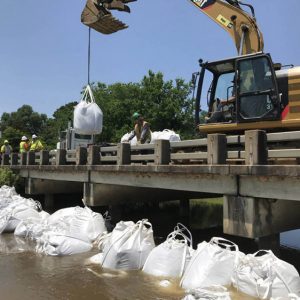
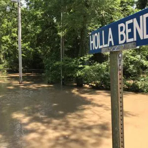
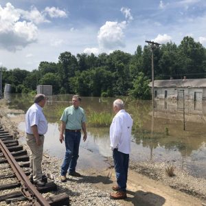
Along the course of the river, people sandbagged their businesses and homes. On May 29, Governor Hutchinson formally requested federal emergency assistance for counties along the river; he also released $350,000 from the Governor’s Disaster Assistance Fund. That same day, water topped a levee in Perry County, leading to the closure of the Arkansas Highway 60 bridge linking Perry and Faulkner counties. A second levee was later topped in Logan County. Early on the morning of May 31, a levee broke just south of Dardanelle (Yell County), putting the community at risk as water poured into the rural area near Holla Bend National Wildlife Refuge; the levee breach was later measured at 346 feet wide and 45 feet deep, and Dardanelle residents worked to construct a temporary levee south of their community to protect the town. That same day, the National Weather Service warned of a levee breach and imminent flash flooding in an industrial area near North Little Rock (Pulaski County); however, it was later revealed that a containment unit near the levee, and not the levee itself, had been breached. Levee damage was also reported in the Yoestown Bottoms area of Crawford County and in rural Faulkner County, where signs of seepage were reported at the Lollie Levee. On June 5, officials acknowledged that Lollie Levee had started to erode, and the following day, county officials recommended the evacuation of area residents. Although a large chunk of the levee did collapse into the river, the levee held, aided by declining flood waters.
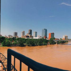
Major flooding moved into central Arkansas in late May and early June. In North Little Rock, the city sealed its floodgates along Riverfront Park in an effort to keep water from entering the Argenta Historic District, and sinkholes appeared on the field of Dickey-Stephens Park. Parts of the Arkansas River Trail in both Little Rock and North Little Rock were underwater during the worst of the flooding, and the Big Dam Bridge was inaccessible due to high water in the area of Murray Lock and Dam. The Tour de Rock charity cycling tour had to be re-routed due to flooding. In Little Rock, Murray Park and Rebsamen Park were underwater by late May, while Cooks Landing Park and parts of Burns Park in North Little Rock were also flooded. As water backed up into the Little Maumelle River, parts of Pinnacle Mountain State Park experienced flooding. However, perhaps the worst-hit recreational site was Two Rivers Park, which lies between the Little Maumelle River and the Arkansas River. A number of expensive homes in the area were inundated. The flood was particularly hard on the city’s homeless population, many of whom often camp by the river. North Little Rock authorities recommended the evacuation of the Dixie Addition, a historically black neighborhood, on June 1, while homes along Willow Beach Road flooded. A portion of the Arkansas River Trail in North Little Rock caved in due to the flooding.
On May 30, eight of the affected counties were declared federal disaster areas; the number was later increased to seventeen: Arkansas, Chicot, Conway, Crawford, Desha, Faulkner, Franklin, Jefferson, Johnson, Lincoln, Logan, Perry, Pope, Pulaski, Searcy, Sebastian, and Yell counties. The flood was later upgraded to a major disaster, thus making available more federal aid for recovery efforts. By the early days of June, the water began to recede in western Arkansas. For example, the Arkansas River crested at Dardanelle on June 2 at 45.3 feet. Three days later, the Arkansas River crested at Little Rock at 29.71 feet, or 6.71 feet above flood stage. Farther down the river, in Pine Bluff, Union Pacific moved rail cars and engines out of the city and pulled up tracks in some areas to allow gaps in the levee system to be filled. The river crested at Pine Bluff on June 6 at 50.86 feet, almost nine feet above flood stage. In the Desha County community of Pendleton, the last town along the Arkansas River before it empties into the Mississippi, the river crested there at 37.63 feet, or 6.63 feet above flood stage, on June 6, and an estimated eighty to ninety percent of homes had been flooded by the time the water began to recede in the middle of the month. In June, the Federal Emergency Management Agency and the U.S. Small Business Administration opened disaster aid sites in North Little Rock and Mayflower (Faulkner County).
At least one fatality was connected to the flood—the drowning of Tommy Richard Adams near Fort Chaffee; he was found in a submerged vehicle on May 28. A large percentage of those whose homes were affected by the flooding did not have flood insurance, raising the question of the necessity of regulating home construction in known floodplains.
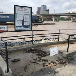
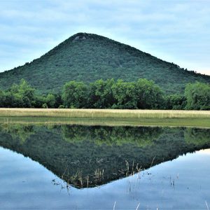
The Flood of 2019 is also expected to have long-term consequences for agriculture in Arkansas and the United States. For example, soybean farmers had already seen their earnings rapidly diminish in the wake of President Donald Trump’s trade war with China, which was a significant market for American soybeans. The flood thus inundated farmland at a time when farmers had few resources at their disposal. River commerce was also greatly impacted, with the flood shutting down river traffic and closing ports at Tulsa and Muskogee, Oklahoma, and Van Buren (Crawford County) and Little Rock. At one point, it was estimated that the closure of the McClellan-Kerr Arkansas River Navigation System was creating a daily loss of $23 million to the state’s gross domestic product. Tourism also suffered, given that many popular sites, such as Mount Nebo State Park, are located along the river, as are many of the routes used to access these sites.
The flood also drew attention to the aging infrastructure along the Arkansas River. For example, many of the levees were built during the 1940s and 1950s and had long been in need of maintenance and repair; too, many of the state’s levee boards were either inactive or dysfunctional. A 2017 investigation by the Arkansas Democrat-Gazette found that, of those levees assessed by the Corps of Engineers, more than half in the state were labeled as being in “unacceptable” condition. Most of the locks and dams that constitute the McClellan-Kerr Arkansas River Navigation System had been completed in the late 1960s or early 1970s. In 2014, officials in Oklahoma had warned that the entire system had a backlog of maintenance amounting to $100 million, most of which was ranked as “critical,” meaning capable of failing within five years, and while funding for system maintenance has occasionally arisen in congressional testimony, these requests have been without resolution. The system was never designed to prevent flooding but was, instead, built to maintain a regular depth along the Arkansas River in order to facilitate river traffic.
The flood also had effects far beyond the state. Excess phosphorous and nitrogen, the product of sewage release and the use of fertilizers in large-scale farming, are regularly picked up by the Mississippi River and transported to the Gulf of Mexico, where they create a hypoxic zone that kills or reduces aquatic life. The scale of the Flood of 2019 meant that the discharge of these substances, especially given that the floodwaters impacted so much agricultural land, was far greater than usual and thus capable of expanding the gulf’s “dead zone.” In addition, these floodwaters likely sparked an outbreak of toxic cyanobacteria that led to the closure of some Mississippi beaches starting in late June 2019.
By late May 2020, many of the levees damaged in the flood were still in a state of disrepair. Come the following March, work on levees in Faulkner and Perry counties was being wrapped up.
For additional information:
Bowden, Bill. “Corps Says It Mitigates, Mother Nature Dictates.” Arkansas Democrat-Gazette, June 9, 2019, p. 5A.
———. “Floods Expected as River Rises.” Arkansas Democrat-Gazette, May 24, 2019, pp. 1B, 5B.
———. “Some Flood-Hit Parks Still Closed.” Arkansas Democrat-Gazette, September 6, 2019, pp. 1B, 8B.
———. “Watch Water, Some in State Told.” Arkansas Democrat-Gazette, June 13, 2019, p. 2A.
———. “With Water Falling, Residents Go Home to Assess What’s Left.” Arkansas Democrat-Gazette, June 5, 2019, p. 5A.
Bowden, Bill, and Debra Hale-Shelton. “Fort Smith Crest Revised a Bit.” Arkansas Democrat-Gazette, May 29, 2019, pp. 1A, 5A.
Bowden, Bill, and Stephen Simpson. “As River Rises, Worry Mounts.” Arkansas Democrat-Gazette, May 28, 2019, pp. 1A, 4A.
Ellis, Dale. “2 Cities Still in Major Flood Stage.” Arkansas Democrat-Gazette, June 12, 2019, p. 4A.
———. “4 Flood-Hit Counties Added to Federal List for Disaster Aid.” Arkansas Democrat-Gazette, June 15, 2019, pp. 1A–2A.
———. “Communities in Flood’s Path Assess Damage.” Arkansas Democrat-Gazette, June 14, 2019, pp. 1B, 5B.
———. “Flooded Households Eligible for Food Aid.” Arkansas Democrat-Gazette, July 16, 2019, pp. 1B, 6B.
———. “Governor: Flood Ruin ‘New Territory.’” Arkansas Democrat-Gazette, June 5, 2019, pp. 1A, 5A.
———. “Jefferson County Crosses Fingers.” Arkansas Democrat-Gazette, June 7, 2019, p. 4A.
———. “PB Officials Brace for River Crest, Remain Optimistic.” Arkansas Democrat-Gazette, June 4, 2019, p. 2A.
———. “PB Residents Prepare, Then Wait, Watch.” Arkansas Democrat-Gazette, June 1, 2019, p. 5A.
———. “Pine Bluff, Pendleton Girded, Await River’s Wrath.” Arkansas Democrat-Gazette, June 6, 2019, p. 5A.
———. “Red Cross, Community Partner for Flood Relief.” Arkansas Democrat-Gazette, June 21, 2019, pp. 1B, 3B.
———. “River Calmer, Ravaged Levee Holding.” Arkansas Democrat-Gazette, June 9, 2019, pp. 1A, 5A.
———. “River Crests in 2 Spots, Starts to Fall.” Arkansas Democrat-Gazette, June 8, 2019, pp. 1A, 4A.
———. “Talk Inside Shelter Is about Loss, Days Ahead.” Arkansas Democrat-Gazette, June 7, 2019, p. 4A.
———. “Time to Go, Police Advise.” Arkansas Democrat-Gazette, June 2, 2019, pp. 1A, 7A.
———. “Town Takes Stock as River Recedes.” Arkansas Democrat-Gazette, June 13, 2019, pp. 1A–2A.
Farrar, Lara. “Levee Repairs Nearing Finish.” Arkansas Democrat-Gazette, March 30, 2021, pp. 1B, 6B.
Gladden, Alex. “Many Waiting out Flood.” Arkansas Democrat-Gazette, June 3, 2019, pp. 1A, 4A.
———. “Police Say Driver Victim of Flooding.” Arkansas Democrat-Gazette, May 29, 2019, p. 5A.
———. “Storms Drop Rain in State, Spawn Localized Flooding.” Arkansas Democrat-Gazette, May 30, 2019, p. 5A.
Grabenstein, Hannah, and Jim Salter. “Flooding Takes Toll on Tourism Business.” Arkansas Democrat-Gazette, June 10, 2019, p. 4A.
Hale-Shelton, Debra, and Stephen Simpson. “Flood Threat Rises around Lake Conway.” Arkansas Democrat-Gazette, June 4, 2019, pp. 1A, 3A.
Herzog, Rachel. “Central Arkansas Waits, Hopes Rain Stays Away.” Arkansas Democrat-Gazette, June 4, 2019, pp. 1A, 3A.
———. “Levee District Secures $2M to Pay for Repairs.” Arkansas Democrat-Gazette, July 12, 2019, pp. 1B, 3B.
———. “LR, NLR Gear for Crest.” Arkansas Democrat-Gazette, May 31, 2019, pp. 1A, 7A.
Herzog, Rachel, Jake Sandlin, and Alex Gladden. “As Waters Ebb, City Parks Left Miry Mess.” Arkansas Democrat-Gazette, June 9, 2019, pp. 1A, 4A.
Lockwood, Frank E. “State Now under Emergency Declaration.” Arkansas Democrat-Gazette, June 1, 2019, p. 5A.
Manandhar, Rejina, Ekong J. Peters, and Bethany Swindell. International Journal of Disaster Risk Reduction 116 (January 2025). https://doi.org/10.1016/j.ijdrr.2024.105134 (accessed December 26, 2024).
Monk, Ginny.”’19 Damage Still on Minds as Officials Monitor River.” Arkansas Democrat-Gazette, June 7, 2020, pp. 1A, 10A.
———. “LR’s Homeless Flee Flooding.” Arkansas Democrat-Gazette, May 31, 2019, pp. 1B, 3B.
Oman, Noel. “Corps Official: River Channel an Unknown.” Arkansas Democrat-Gazette, June 20, 2019, pp. 1A, 10A.
———. “High Water Levels Close Roads, Spans.” Arkansas Democrat-Gazette, May 30, 2019, p. 4A.
Oman, Neal, and Stephen Steed. “High Water Closes Ports.” Arkansas Democrat-Gazette, May 30, 2019, pp. 1A, 4A.
Sandlin, Jack. “Ball Field Sinkholes Fly in the Ointment.” Arkansas Democrat-Gazette, June 23, 2019, pp. 1B, 6B.
———. “Flooding Damage at $2M in NLR Parks, Riverfront.” Arkansas Democrat-Gazette, September 20 2019, p. 3B.
———. “Flood-Fouled RV Site Tidied up, Set to Open.” Arkansas Democrat-Gazette, June 30, 2019, pp. 1B, 7B.
Simpson, Stephen. “Disaster-Aid Sites Open in 2 Cities.” Arkansas Democrat-Gazette, June 24, 2019, pp. 1B–2B.
———. “FEMA Flood-Relief Requests Due.” Arkansas Democrat-Gazette, August 6, 2019, pp. 1B, 3B.
———. “Flood-Recovery Work Begins.” Arkansas Democrat-Gazette, June 11, 2019, pp. 1A–2A.
———. “Lake Conway Still on the Rise.” Arkansas Democrat-Gazette, June 6, 2019, pp. 1A, 5A.
———. “NLR Crews Keep Floodwaters Back, Brace for Rain.” Arkansas Democrat-Gazette, June 5, 2019, p. 5A.
———. “‘One More Day’ Is Hope for Levee Hold.” Arkansas Democrat-Gazette, June 8, 2019, pp. 1A, 5A.
———. “Stay off River, Officials Warn.” Arkansas Democrat-Gazette, June 10, 2019, pp. 1A, 4A.
Simpson, Stephen, and Clara Turnage. “Flooding in Area of NLR Raises Late-Night Levee Alert.” Arkansas Democrat-Gazette, June 1, 2019, pp. 1A, 4A.
———. “Floods Rolling in with River, State Warned.” Arkansas Democrat-Gazette, May 27, 2019, pp. 1A, 8A.
———. “Levee Failing, Time to Leave, Residents Told.” Arkansas Democrat-Gazette, June 7, 2019, pp. 1A, 5A.
———. “State Leaders Survey Flooding.” Arkansas Democrat-Gazette, May 31, 2019, pp. 1A, 6A.
Simpson, Stephen, Clara Turnage, and Debra Hale-Shelton. “Arkansas River Tributaries to Fill to Flooding Also.” Arkansas Democrat-Gazette, May 29, 2019, p. 5A.
Simpson, Stephen, and Rachel Herzog. “First Road Closes as LR Area Steels for High Water’s Arrival.” Arkansas Democrat-Gazette, May 30, 2019, pp. 1A, 4A.
———. “Normal Arkansas River Navigation Still Weeks Off.” Arkansas Democrat-Gazette, June 12, 2019, p. 5A.
Turnage, Clara. “Boy Clings to Vine Till Rescuers Arrive.” Arkansas Democrat-Gazette, June 6, 2019, p. 4A.
———. “Crest in LR Relief for Some, Not All.” Arkansas Democrat-Gazette, June 6, 2019, pp. 1A, 4A.
———. “Flood Watch Reaches State of Emergency.” Arkansas Democrat-Gazette, May 25, 2019, pp. 1A, 8A.
———. “Flood-Hit Advised to File Claims Now.” Arkansas Democrat-Gazette, June 9, 2019, pp. 1A, 6A.
———. “Flooding Keeps Weather Service Busy.” Arkansas Democrat-Gazette, June 10, 2019, pp. 1A, 4A.
———. “Floods to Slow Power Restoration for Those in Dark.” Arkansas Democrat-Gazette, May 31, 2019, p. 6A.
———. “Floodwaters Reach Homes in Fort Smith.” Arkansas Democrat-Gazette, May 26, 2019, pp. 1B, 7B.
———. “Governor Vexed by Water Release as Flood Tactic.” Arkansas Democrat-Gazette, June 16, 2019, pp. 1A, 9A.
———. “Levee Break Puts Dardanelle in Peril.” Arkansas Democrat-Gazette, June 1, 2019, pp. 1A, 4A.
———. “Levee Going Up; So Is Water.” Arkansas Democrat-Gazette, June 2, 2019, pp. 1A, 6A.
———. “LR, NLR Soaked; River’s Crest Shifts.” Arkansas Democrat-Gazette, June 5, 2019, pp. 1A, 4A.
———. “Shelter Pets Taken to New States.” Arkansas Democrat-Gazette, June 9, 2019, pp. 1B, 8B.
Turnage, Clara, and Dale Ellis. “Slowing Water Raises Hopes.” Arkansas Democrat-Gazette, June 3, 2019, pp. 1A, 4A.
Turnage, Clara, and Emily Walkenhorst. “After Flooding, Governor Sees Need for Levee Review.” Arkansas Democrat-Gazette, June 12, 2019, pp. 1A, 4A.
Turnage, Clara, Noel Oman, and Dale Ellis. “River Running High, Fast, Boaters Warned.” Arkansas Democrat-Gazette, May 23, 2019, pp. 1B, 6B.
Walkenhorst, Emily. “After 2019 Disaster, Levees Remain in Disrepair.” Arkansas Democrat-Gazette, May 31, 2020, pp. 1A, 11A.
———. “Governor Seeks $10M for Levees.” Arkansas Democrat-Gazette, June 28, 2019, pp. 1A, 5A.
———. “Money a Big Barrier in Recovery.” Arkansas Democrat-Gazette, July 5, 2020, pp. 1A, 12A.
———. “State’s Levees Hold up, but System’s Fragility Laid Bare.” Arkansas Democrat-Gazette, June 16, 2019, pp. 1A, 8A.
———. “State’s Water Adding to Dead Zone.” Arkansas Democrat-Gazette, June 30, 2019, pp. 1B, 7B.
Wickline, Michael R., Bill Bowden, and Debra Hale-Shelton. “Governor Asks Trump for Help for Flooded State.” Arkansas Democrat-Gazette, May 30, 2019, pp. 1A, 5A.
Staff of the CALS Encyclopedia of Arkansas


Comments
No comments on this entry yet.