501-918-3025
calsfoundation@cals.org
calsfoundation@cals.org
| Latitude and Longitude: | 34°04’30″N 092°33’20″W |
|---|---|
| Elevation: | 308 feet |
| Area: | 0.99 square miles (2020 Census) |
| Population: | 222 (2020 Census) |
| Incorporation Date: | May 3, 1907 |
Historical Population as per the U.S. Census:
| 1810 | 1820 | 1830 | 1840 | 1850 | 1860 | 1870 | 1880 | 1890 | 1900 |
|---|---|---|---|---|---|---|---|---|---|
| – | – | – | – | – | – | – | – | – | – |
| 1910 | 1920 | 1930 | 1940 | 1950 | 1960 | 1970 | 1980 | 1990 | 2000 |
| 386 | 532 | 558 | 687 | 533 | 528 | 566 | 568 | 452 | 442 |
| 2010 | 2020 | ||||||||
| 343 | 222 |
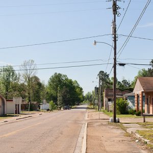
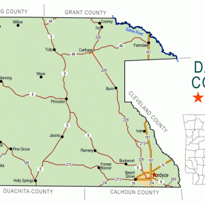
Carthage is located in northern Dallas County, on Highways 48 and 229. Formed by the railroad and timber industries, it continues to support a working sawmill in the twenty-first century.
According to a plaque erected in Carthage in 1976, the area was “a crossroad for settlers in pioneer times due to the abundance of wild game and water springs.” Large plantations grew cotton and other crops, and communities such as Tulip (Dallas County) and Princeton (Dallas County) built schools, churches, and businesses. As part of the Camden Expedition, the Engagement at Jenkins’ Ferry was fought a few miles north of the present location of Carthage in April 1864. The end of the Civil War meant the end of slavery in Arkansas, which changed the plantation economy. Many plantations, however, continued to operate using tenant farmers, mostly African American, performing the same function that slaves had done before the war. New communities developed at this time, including Lea Ridge, an African-American settlement in northern Dallas County.
The Little Rock and Southern Railroad was incorporated in 1902 to create a rail line running from Haskell (Saline County) to El Dorado (Union County). Tracks were built in northern Dallas County in 1905, the same year that the Chicago, Rock Island and Southern Railroad acquired the Little Rock and Southern line. Residents of Lea Ridge moved several miles to the west to live near the railroad line, gaining access to jobs and businesses. The new community was named Carthage, after a prominent city in northern Africa. The city of Carthage was platted in 1906 and incorporated in 1907. A post office was established in 1906.
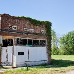
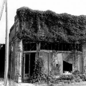
The primary industry served by the railroads was the timber industry. Several railroads were constructed through the region, and their influence caused the rise of cities such as Carthage and Fordyce (Dallas County) and the collapse of others such as Tulip and Princeton. The Rock Island line was crossed just north of Carthage by a second line connecting Pine Bluff (Jefferson County) to Gum Springs (Clark County). Wood from harvested trees was transported by rail, although much was also used to build homes, churches, schools, and businesses. A bank, designed by noted architect Charles Thompson, was built in Carthage in 1907 using local wood, and a Methodist church was erected in 1910, also using local wood. Both structures are on the National Register of Historic Places.
Also on the National Register is the African-American section of the Hampton Springs Cemetery in Carthage. The burial practices of the black residents of Carthage were a blend of African and Euro-American traditions, and the cemetery includes markers of cast concrete, ceramic pipe, oil lamps, wooden stakes, and petrified wood as well as offerings of mussel shells, broken glass and ceramic jars, bottles, plates, and pitchers. The population of Carthage remains largely African American, with black residents making up nearly eighty percent of the 343 residents counted by the 2010 census.
The largest employer in Carthage as of 2013 is Idaho Timber, a sawmill with a capacity of 60 million board feet per year. The city has at least eight churches, including Baptist, Missionary Baptist, Methodist, Presbyterian, Church of God in Christ, and African Methodist Episcopal (AME). Children in Carthage are bused to school in Malvern (Hot Spring County). Jenkins Ferry Battleground State Park was established north of Carthage in 1961.
During the summer of 2019, the town’s water well collapsed, requiring the town temporarily to rely on water tanks provided by the Arkansas National Guard. The town had been attempting to get grant money to fix the system, but it failed before it could be repaired. The well was finally repaired on April 2020.
For additional information:
Brown, Sarah. “Dallas County Multiple Resource Area.” National Register of Historic Places nomination form, 1983. Online at https://npgallery.nps.gov/GetAsset/a71672d8-b647-4f6b-a73b-cbf44aeb418e (accessed June 28, 2025).
Steven Teske
Butler Center for Arkansas Studies


Comments
No comments on this entry yet.