501-918-3025
calsfoundation@cals.org
calsfoundation@cals.org
The Sulphur River is a stream that flows in northeastern Texas and in Miller County before joining the Red River. Continuing for a total of 175 miles, the river extends into Arkansas for the final fifteen miles of its length. Some sources refer to the river as a fork of the Red, calling it the Sulphur Fork. It is named for the gypsum deposits that it flows through.
The river is formed from two forks, the North Sulfur River and the South Sulfur River, that meet south of Cunningham, Texas. The southern fork is formed south of Wolfe City, Texas, while the northern fork rises south of Gober, Texas. A middle fork of the river flows north of Commerce, Texas, and enters Jim Chapman Lake, as does the southern fork.
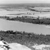
Multiple creeks and other small streams feed into the Sulphur River. The Wright Patman Dam impounds the river southwest of Texarkana (Miller County), creating the Wright Patman Lake, formerly known as Lake Texarkana. The lake spans Cass and Bowie counties.
Re-formed at the spillway that empties from the lake, the Sulphur River continues to the east and enters Arkansas about six and a half miles later. Just before entering Arkansas, the river passes north of an industrial park in Domino, Texas, and water from it is used in various businesses, including a paper mill.
Entering Arkansas just south of Lake Landon, an oxbow body of water that lies on the border of the two states, the Sulphur flows in a southeasterly direction. The river crosses State Highway 237 and flows through the Sulphur River Wildlife Management Area. Several small creeks join the river as it flows to the east. Interstate 49 and U.S. Highway 71 cross the river north of Doddridge (Miller County). A boat launch ramp is located near the bridge that carries Highway 71 over the river.
The river empties into the Red River about two and a half miles east of Doddridge. The mouth of the river is just north of a bridge carrying Arkansas Highway 160. The bank opposite the mouth of the river marks the county line between Miller and Lafayette counties.
The mouth of the river was an important site during the territorial period of the early nineteenth century. Operating from 1817 to 1822, the Sulphur Fork Factory served to develop and maintain relationships with nearby Native Americans, most notably the Caddo, while at the same time stopping Spanish influence from nearby Texas. (The Indian factory system was a system of trading posts created by an act of Congress in 1795 with the intention of developing and maintaining Native American friendship and allegiance through government control of trade on the frontiers of the new nation.) The factory replaced an earlier one that operated in Natchitoches, Louisiana. A small number of troops from the U.S. Army served at the post, which served as a center of supply and commerce in the area. The original commander of the factory, John Fowler, served from 1817 to 1820. His replacement, William McClellan, served from 1820 to 1822, when the factory system was disbanded.
During and immediately after the Civil War, outlaw Cullen Montgomery Baker hid in the bottomlands on both sides of the river.
No towns are located along the stream in Arkansas. The nearest settlement is Fouke (Miller County), which is located about six miles to the northeast of the river. The area drained by the Sulphur River in Arkansas is sparsely populated and used for agricultural purposes, most notably timber. The watershed of the river in Arkansas includes much of southern Miller County.
For additional information:
Johnson, Boyd W. “Cullen Montgomery Baker the Arkansas-Texas Desperado.” Arkansas Historical Quarterly 25 (Autumn 1966): 229–239.
Key, Joseph Patrick. “Indians and Ecological Conflict in Territorial Arkansas.” Arkansas Historical Quarterly 59 (Summer 2000): 127–146.
Magnaghi, Russell M. “Sulphur Fork Factory, 1817–1822.” Arkansas Historical Quarterly 37 (Summer 1978): 168–183.
Sulphur River, U.S. Geological Survey. https://waterdata.usgs.gov/monitoring-location/07344275/#period=P1Y&showMedian=true (accessed April 9, 2025).
Sulphur River Wildlife Management Area, Arkansas Game and Fish Commission. https://www.agfc.com/wma/sulphur-river-wma/ (accessed April 9, 2025).
David Sesser
Southeastern Louisiana University


Comments
No comments on this entry yet.