
501-918-3025
calsfoundation@cals.org
calsfoundation@cals.org
| Latitude and Longitude: | 36°19’12″N 090°36’07″W |
|---|---|
| Elevation: | 282 feet |
| Area: | 0.42 square miles (2020 Census) |
| Population: | 147 (2020 Census) |
| Incorporation Date: | November 14, 1896 |
Historical Population as per the U.S. Census:
|
1810 |
1820 |
1830 |
1840 |
1850 |
1860 |
1870 |
1880 |
1890 |
1900 |
|
|---|---|---|---|---|---|---|---|---|---|---|
|
– |
– |
– |
– |
– |
– |
– |
– |
– |
410 |
|
|
1910 |
1920 |
1930 |
1940 |
1950 |
1960 |
1970 |
1980 |
1990 |
2000 |
|
|
362 |
390 |
486 |
375 |
417 |
339 |
375 |
503 |
317 |
358 |
|
|
2010 |
2020 |
|
|
|
|
|
|
|
|
|
|
287 |
147 |
|
|
|
|
|
|
|
|
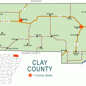
Knobel is a city in Clay County, about seven miles south of Corning (Clay County). Once a stop on the Iron Mountain Railroad, Knobel remains a minor agricultural center for the surrounding region.
Frequently flooded by the Mississippi River and shaken by the New Madrid Earthquakes of 1811–1812, northeastern Arkansas remained sparsely settled until after the Civil War. The region consisted largely of swampland and hardwood forests, and no one lived permanently in the place that would become Knobel until after the Civil War. Many people passed through the area, however, since the site was on the road that connected Chalk Bluff (Clay County) on the St. Francis River to Pocahontas (Randolph County).
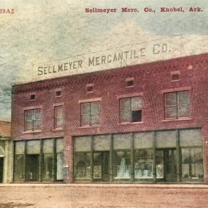
In 1866, J. H. Allen began farming about two miles west of what would one day be Knobel. Ten years later, Allen was joined by Richard and J. T. Gilchrist, a father and son who operated a sawmill nearby. Brothers B. H. and Joe Sellmeyer also arrived in the area, working the timber lands as contractors for the Iron Mountain Railroad. The main line followed the path of the old highway from Chalk Bluff to Pocahontas, but a line separated from the branch near Gilchrist’s sawmill and ran south to Helena (Phillips County). The Sellmeyers opened a general store at the rail crossing, and J. T. Gilchrist operated a saloon and billiards hall for the railway workers and the lumber workers. A post office appeared at Knobel in 1874, named after railroad engineer Gus Knobel.
In 1884, the railroad spent $10,000 to build a hotel at Knobel. Known as Knobel House, it achieved a regional reputation for its accommodations and service. Eli Loda, manager of the hotel, purchased 100 acres of surrounding land and had a city platted; lots began to be sold in 1888. By 1889, the community had three general stores, a school house, and about twenty-five homes, as well as the post office and several railroad buildings. In 1892, the Keller and Tann Manufacturing Company of St. Louis, Missouri, established a handle and spoke factory at Knobel that employed roughly 600 men. The city was incorporated in 1896.
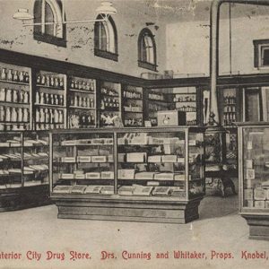
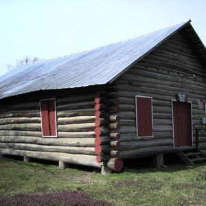
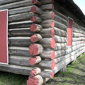
After 1910, the lumber supply had been exhausted. The factory closed, and many families left the area. An American Legion post was established in Knobel after World War I; its building is now on the National Register of Historic Places. During the 1921–1922 school year, the Knobel School District became embroiled in a lawsuit regarding rules of conduct banning of cosmetics, although the Supreme Court of Arkansas ruled for the district in Pugsley v. Sellmeyer. By 1933, Knobel’s population had dropped to 200, according to historian Robert W. Webb. The city had five grocery stores, one drugstore, two butcher shops, two shoe shops, two blacksmith shops, two sawmills, one cotton gin, and two filling stations. During the Depression, many of these businesses failed. During World War II, Knobel had a prisoner-of-war branch camp of Camp Joseph T. Robinson.
Improvement of the state’s highways allowed residents to shop in larger cities such as Corning and Pocahontas, or even to travel to Memphis, Tennessee, or Little Rock (Pulaski County) and return on the same day. The school system was consolidated into Corning’s school district.
Agricultural interests prevented the city from fading to obscurity, and the population had reached a high of 503 by 1980. In the twenty-first century, employers in Knobel include a Riceland Foods regional office, Carter-Cox Seeds Inc., and a branch of Farm Service Inc., an agricultural consulting firm. The city also has a Baptist church, a branch of First National Bank, a grocery store, a car sales lot, and a country crafts outlet. The city remains surrounded by rich farmland. By 2010, the population was 287.
For additional information:
The Goodspeed Biographical and Historical Memoirs of Northeastern Arkansas. Chicago: Goodspeed Publishing Co., 1889.
Webb, Robert W. History and Traditions of Clay County. Mountain Home, AR: Shiras Bros. Print Shop, 1933.
Steven Teske
Butler Center for Arkansas Studies


Knobel lies about three miles south of the Black River and eight miles west of Crowley’s Ridge. The ridge protects Knobel from flooding from the St. Francis or Mississippi Rivers and provides runoff to Cache River, which runs diagonally northeast to southwest about six miles east of Knobel at its closest point. Knobel rarely, if ever, flooded due to its elevation and distance from rivers; however, sloughs are all around the town.