501-918-3025
calsfoundation@cals.org
calsfoundation@cals.org
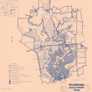
Felsenthal National Wildlife Refuge encompasses approximately 65,000 acres at the confluence of the Ouachita and Saline rivers, spreading across the borders of three counties—Union, Bradley, and Ashley—in southeastern Arkansas near the Louisiana Border. The refuge takes its name from the nearby town of Felsenthal (Union County).
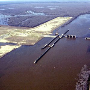
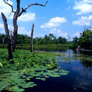
The refuge was established in 1975 in order to mitigate the environmental impact of the Ouachita and Black Rivers Navigation Project of the U.S. Army Corps of Engineers, which entailed the construction of locks and dams along both rivers in order to facilitate river traffic and prevent flooding. Felsenthal Lock and Dam on the Ouachita River impounds Lake Jack Lee, which the refuge surrounds. Numerous other waterways, such as Caney Bayou and Big Brushy Creek, flow into the refuge, which is also dotted by numerous smaller lakes, including a few oxbows of the Ouachita River. Felsenthal National Wildlife Refuge contains the world’s largest green tree reservoir consisting of the Felsenthal Pool, a 40,000-acre area of bottomland hardwood forest, 15,000 acres of which are regularly flooded, though this flooded area increases to 36,000 acres during the winter to the benefit of the trees located there. Prior to the completion of the project, only about 5,000 acres were under water on a regular basis.
This flooding is critical to the mating cycles of numerous waterfowl, making the refuge a prime location for birdwatchers and hunters, especially as it is located along the Mississippi Flyway and hosts numerous species of waterfowl during the winter months. Among the other birds that can be sighted at the refuge are the endangered red-cockaded woodpecker and the bald eagle. The American alligator also lives within the refuge’s borders. In addition, the width of the riverbed within the refuge allows extensive fishing opportunities. The Casey Jones Wildlife Management Area and the Beryl Anthony/Lower Ouachita Wildlife Management Area are located in the immediate vicinity of the refuge, and across the border in Louisiana is the Upper Ouachita National Wildlife Refuge, which also provides a wintering habitat for ducks and geese. The refuge also contains a number of archaeological sites, including many relating to the Caddo tribe.
For additional information:
Doggett, Jacob W. “Assessment of Northern Bobwhite Survival and Fitness at Felsenthal National Wildlife Refuge, Arkansas.” MS thesis, Grand Valley State University, 2015. Online at https://scholarworks.gvsu.edu/theses/764/ (accessed July 7, 2022).
Felsenthal National Wildlife Refuge. https://www.fws.gov/refuge/felsenthal (accessed March 16, 2022).
Wolfe, Lisa. “Crossett and Felsenthal: Making a Big Splash in South Arkansas.” City & Town, November 1986, pp. 10–11.
Staff of the CALS Encyclopedia of Arkansas


I spent three or so years creating the Felsenthal Wildlife Map to help explain the Ouachita River. I was in the Arkansas Legislature when Rockefeller was governor.
My military title is a Navy Air Captain. I was on active duty off the coast of China on the USS Midway in 1958. We were on station to prevent “Chairman Mayo” from launching his first effort to take Taiwan, a forgotten encounter. I understand maps.
Big Worth was my dad whose first job, arriving in Warren Ark in 1934, as a Lumber Grader paid 10 cents an hour. I was born in Warren, and Dad paid Dr. Snodgrass $10 in dimes he had saved for my birth. He took me fishing in Felsenthal many times–arriving just at daylight on Saturday mornings!