


501-918-3025
calsfoundation@cals.org
calsfoundation@cals.org
Although technically a part of the U.S. Army, the U.S. Army Corps of Engineers (USACE) has played a vital role in the development of civilian transportation infrastructure and water resources since Congress passed the first river and harbors bill in 1824 and charged the corps with maintaining navigational channels. Work on the Ohio, Missouri, and Mississippi rivers received first priority, but as settlers moved farther west, attention soon focused on other navigable streams.
Until 1916, Congress authorized only navigational improvements on rivers. Flood control only entered the corps’ mandate indirectly, as levees were considered navigational aids. However, as agricultural and transportation needs grew and the national economic importance of the lower Mississippi River Valley became evident, politicians found it easier to fund large-scale, multi-purpose projects for flood control, economic, and defense purposes.
The Formation of the Little Rock District (Civil Works)
The corps’ Civil Works program involves flood control, water supply, hydroelectric power generation, navigation, recreation, and environmental regulation. The boundaries for the Civil Works program often follow watersheds or parts of watersheds. There are nine Civil Works Divisions, two of which cover Arkansas: the Southwestern Division and the Mississippi Valley Division. These divisions are split into districts. Arkansas districts include the Little Rock District (Southwestern Division) and parts of the Memphis and Vicksburg districts (Mississippi Valley Division). Generally, the Memphis and Vicksburg districts oversee the lowland river basins in Arkansas, while the Little Rock District primarily oversees the highland areas.
Bounded on the west by the Arkansas state line, the district today includes the Little River basin, especially its Little River and tributaries above Fulton (Hempstead County), the Arkansas River basin above Pine Bluff (Jefferson County), and the White River basin above Georgetown (White County) north and westward into the Arkansas and Missouri Ozarks.
Some work was done by the corps in the state as early as 1828. This work consisted mostly of snag removal to improve steamboat navigation. It was not, however, until 1881 that an engineering office at Little Rock (Pulaski County) was established. Captain Thomas H. Handbury was assigned to the office. The corps did not officially recognize districts until 1913; however, Handbury is generally regarded as the first Little Rock district engineer.
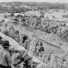
Under Handbury, contraction (wing dams) and revetment work (bank stabilization) began on the Arkansas River to confine the channel and curtail erosion threatening the town of Pine Bluff. Dredging and removal of snags formed the other half of the young district’s duties. Much of this early river work did not withstand the floods that followed.
Built in a flood plain, streets and houses of Pine Bluff had eroded into the river after flooding in 1882–1884. Pine Bluff continued to be a problem for the corps well into the twentieth century, when technological improvements in design and increased manpower made better levees possible.
During the last decade of the nineteenth century and first decade of the twentieth, the corps busied itself with surveys and navigational improvements on the Arkansas and White rivers. Ten locks and dams were approved for the White. Three were built at Batesville (Independence County), but the project was made obsolete by a railroad and was discontinued in 1911.
The period between the first two world wars saw a reduction of corps activity and a national emphasis upon civil engineering projects. Subsumed under the Memphis District in 1921, the Little Rock District later emerged a much larger district in 1937.
District Projects of Significance
Following the Flood of 1927, pressure was on Congress to expand the corps’ mission. The sight of almost a million flood refugees over the lower Mississippi Valley stirred popular opinion that the federal government should take responsibility for flood plain protection. Herbert Hoover, as secretary of commerce (1921–1928) and later as president (1929–1933), also championed an expanded federal role in water resources development.
The Flood Control Act of 1928 authorized flood control surveys of the entire Mississippi River and all of its tributaries. As a result, the corps began studying dams and reservoirs on the Arkansas and its tributaries and planning to increase levee protection.
Another great flood occurred in the lower Mississippi Valley in 1937. The Flood Control Act of 1938 approved a general comprehensive flood control plan for the Arkansas River basin and also six multi-purpose dams and reservoirs in the upper White River drainage.
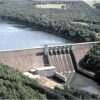
The district’s most notable project, however, was the $1.3 billion McClellan-Kerr Arkansas River Navigation System. It was conceived as early as 1943 and begun as piecemeal control projects, but only in 1960 did Congress authorize a unified navigational development plan. From 1957 to 1970, engineers of both the Little Rock and Tulsa, Oklahoma, districts constructed seventeen locks and dams on the Arkansas River (twelve in Arkansas), extending navigation from near the river’s mouth at the Mississippi to the Port of Catoosa near Tulsa—a distance of 445 miles. Vessels enter the system from the Mississippi through the ten-mile White River Entrance Channel, which provides an easier-to-maintain navigational channel to the Arkansas. Two hydroelectric power plants were also constructed at Ozark (Franklin County) and Dardanelle (Yell County). President Richard M. Nixon dedicated the waterway on June 5, 1971.
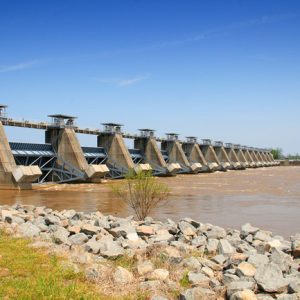
The last lock and dam to be built on the McClellan-Kerr Arkansas River Navigation System was Montgomery Point Lock and Dam, making a total of eighteen locks and dams. It was dedicated in 2004 and was built in response to the chronic low-water problem in the White River Entrance Channel.
The district oversees about sixty-nine levees in Arkansas, thirteen high-head dams and reservoirs, and nearly 500,000 acres of public land and water. It operates and maintains 165 recreation areas on lakes and rivers in southern Missouri and most of Arkansas, which log 30 to 35 million visits per year, and it leases 300 concessions to commercial businesses. Six dams and reservoirs on the upper White River and tributaries have transformed a once remote area of the Ozarks into a recreational playground of national significance.
District Economics
The Little Rock District’s Civil Works appropriation for 2009 was $128.5 million. The district received a supplemental appropriation of nearly $137 million through the American Recovery and Reinvestment Act of 2009.
According to the district, its projects prevented nearly $430 million in flood losses in 2008. Its seven hydropower plants generated enough electricity to power nearly 400,000 homes, about $2 billion in commodities were shipped on the Arkansas River, and district parks accounted for $294 million in visitor spending.
Controversial Projects
Many corps projects are authorized but never appropriated because of a lack of congressional funding. Some of the projects are controversial, and critics charge the corps with being overly optimistic with cost-benefit analyses and unprogressive and environmentally insensitive in its project development. The public debate over the construction of Lone Rock dam on the Buffalo River in the 1960s is an example.
During the 1940s through the 1960s, many communities and politicians pushed hard for dam building. In 1948, Congressman James W. Trimble of the Third Congressional District urged passage of an omnibus flood control bill and declared, “The United States should build every flood control and hydro-electric dam possible.” Not only did cities, towns and development interests such as the local Chambers of Commerce enthusiastically endorse dams in their areas, but the corps had readied extensive plans for dams throughout the upper river basins in the state.
Conservationists such as Neil Compton argued that it was exactly this idea of progress that brought in a destructive kind of commercialization and development. Historic sites were inundated, rare plants and wildlife habitat destroyed, and geologic features marred or flooded. These changes, they argued, modified the scenic beauty of the Ozarks to such an extent as to make it unrecognizable.
As a result of this debate, an alternative proposal to keep the Buffalo River undammed and protected by the National Park Service gained favor, and it was made the nation’s first National River in 1972. Congress now requires the corps to conduct thorough environmental impact statements on proposed projects, and this process has enabled more public involvement in development of water resources.
For additional information:
Bolton, S. Charles. 25 Years Later: A History of the McClellan-Kerr Arkansas River Navigation System in Arkansas. Little Rock: U.S. Army Corps of Engineers, Little Rock District, 1995.
Browne, Turner. The Last River: Life along Arkansas’s Lower White. Fayetteville: University of Arkansas Press, 1993.
Clay, Floyd M. A History of the Little Rock District, U.S. Army Corps of Engineers, 1881–1979. 2nd ed. Little Rock: Department of the Army, Corps of Engineers, Little Rock District, 1979.
Compton, Neil. The Battle for the Buffalo River: A Twentieth-Century Conservation Crisis in the Ozarks. Fayetteville: University of Arkansas Press, 1992.
Fisher, George. God Would Have Done It If He’d Had the Money. Little Rock: Arkansas Wildlife Federation Conservation Foundation, 1983.
Rathbun, Mary Yeater. Castle on the Rock, 1881–1985: The History of the Little Rock District, U.S. Army Corps of Engineers. Little Rock: U.S. Army Engineer District, Little Rock, 1990.
U.S. Army Corps of Engineers, Little Rock District. http://www.swl.usace.army.mil/ (accessed December 12, 2025).
U.S. Army Corps of Engineers, Southwestern Division. Water Resources Development in Arkansas. Dallas, TX: U.S. Army Corps of Engineers, Southwestern Division, 1995.
Scott Branyan
Rogers, Arkansas


Comments
No comments on this entry yet.