 Southern Guardian
Entry Type: Thing - Starting with S
Southern Guardian
Southern Ladies’ Journal
The Southern Ladies’ Journal, a weekly newspaper for women, operated from 1881 to 1887 in Little Rock (Pulaski County). Launched on June 21, 1881, as a section for women in the Rural and Workman newspaper under the title the Ladies’ Little Rock Journal, it would later become an independent publication. On August 8, 1884, it became the Arkansas Ladies’ Journal; in April 1886, it was renamed the Southern Ladies’ Journal. It ceased publication the following year. Its founding editor was Mary Ann Webster Loughborough, the bestselling author of the Civil War memoir My Cave Life in Vicksburg. Its founding business manager was Sophie Crease, a resident of Little Rock known for her energy and enterprise. A women’s stock company, with …
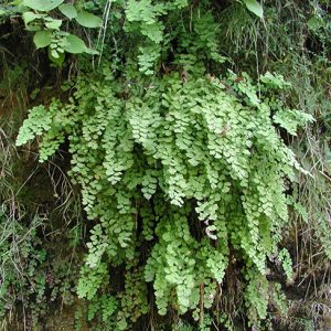 Southern Maidenhair Fern
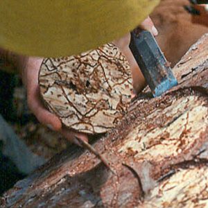 Southern Pine Beetle Damage
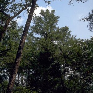 Southern Shortleaf Pine
Southern Strategy [Novel]
In his long career as a journalist, Bob Lancaster wrote a single novel, Southern Strategy, based upon and perhaps inspired by his experiences as a young reporter during the crisis that followed the showdown between Governor Orval E. Faubus and the federal courts over school desegregation at Little Rock (Pulaski County) in 1957. Southern Strategy, published in 1981 by Seaview Books of New York, followed the moral journey of its picaresque main character, Amos Shellnut, a contented sawmill worker whose life in a small town outside Little Rock is disrupted by the sudden flight of his sweetheart Norma to Hollywood to seek her destiny and also by discombobulations in his town caused by Faubus’s racial demagoguery. In the novel, Shellnut, …
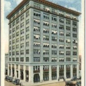 Southern Trust Building
 Southern Trust Building
Southland Park Gaming and Racing
aka: Southland Greyhound Park
Southland Park Gaming and Racing, formerly known as Southland Greyhound Park, is a gambling and entertainment center in West Memphis (Crittenden County) near the intersection of Interstates 55 and 40. Begun as a dog-racing track, it now includes games of skill such as blackjack and live poker games played with electronic cards along with trivia contests, karaoke, and live music. Southland Park began as a dog track in 1956. It was the only gambling venue in the Mid-South region and drew visitors from several nearby states. The track offered pari-mutuel betting (French for “mutual stake”), a system common to horse racing as well as greyhound racing. In this system, bets are put together in a pool with odds established before …
Southwest Experimental Fast Oxide Reactor (SEFOR)
The Southwest Experimental Fast Oxide Reactor (SEFOR), which is located east of Strickler in rural Washington County, was completed in 1969 at the direction of the federal government, specifically the U.S. Atomic Energy Commission, to test the feasibility of breeder reactors in the production of electricity. It closed in 1972, and the University of Arkansas (UA) in Fayetteville (Washington County) took over ownership of the site in 1975 and conducted research at the facility until 1986. A fast breeder reactor such as SEFOR uses fast neutrons for fission, making it possible for the nuclear reactor to produce more new fuel than it consumes, essentially “breeding” new fuel in the process. SEFOR was developed by a consortium of private energy companies, …
Southwest Trail, The [Computer Game]
The Southwest Trail was a 1987 text-based computer game designed by the Minnesota Educational Computing Consortium (MECC) as a follow-up to that company’s highly successful game The Oregon Trail, in which the player assumes the role of the leader of a wagon train following the trail from Missouri to Oregon. However, The Southwest Trail, which follows settlers from the St. Louis, Missouri, area through Arkansas and on to Texas, was much less popular than its predecessor, being seen largely as a cheap imitation of the first. In addition, the game drew criticism for misrepresenting Arkansas in several important ways. The original Oregon Trail game was designed by Don Rawitsch in 1971 for use in his eighth-grade history class. Three years …
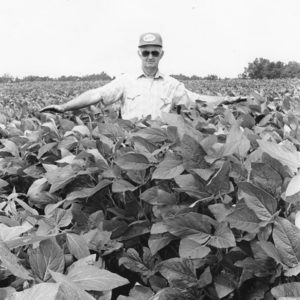 Soybean Field
Spanish Land Grants
Arkansas inherited a complex legacy of land grants from its time as part of Spanish Louisiana. Beginning in 1769, royal governor Alejandro O’Reilly established regulations concerning the size of permissible concessions and the conditions by which applicants could perfect titles to their land. Subsequent governors upheld and expanded similar regulations, but in practice, most grants made during Spanish rule were approved upon request only by the commandant of the nearest settlement. Formal surveys of the grants were rarely made, which further frustrated attempts to determine rightful ownership of granted land once Spanish Louisiana became part of the United States. O’Reilly’s regulations prescribed a three-year probationary period during which claimants were expected to clear the frontage of their land, build ditches …
 Spavinaw Creek Bridge
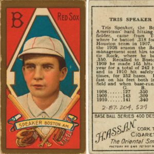 Tris Speaker trading Card
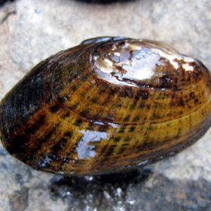
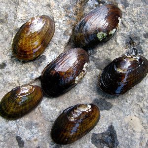
Speckled Pocketbook
aka: Lampsilis streckeri
The speckled pocketbook is a bivalve mollusk belonging to the family Unionidae, commonly referred to as freshwater mussels, naiads, or clams. Each freshwater mussel is composed to two halves (valves) of a hard outer shell with the living animal (soft tissues) residing securely inside. The speckled pocketbook, scientific name Lampsilis streckeri, was described as a species new to science in 1927 by Lorraine Screven Frierson, a naturalist and landowner/merchant/planter residing south of Shreveport in the company town of Frierson, Louisiana. Frierson named the species in honor of his friend, colleague, and fellow naturalist John K. Strecker of Waco, Texas. Adults may reach a length of slightly more than 3.5 inches (or more than 90 millimeters), with a maximum life expectancy …
 Speckled Pocketbook
 Speckled Pocketbook
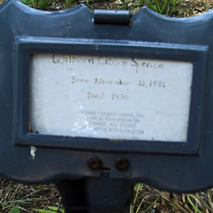 Cicero Spence Grave
Spirit of the American Doughboy Monuments
The Spirit of the American Doughboy Monuments in Helena-West Helena (Phillips County) and Fort Smith (Sebastian County) are memorial sculptures erected following World War I to honor Arkansas servicemen who fought and died in the war. The Arkansas statues were dedicated as part of a nationwide series of Doughboy sculptures designed by artist E. M. “Dick” Viquesney. At least 136 Viquesney Doughboys survive in thirty-five U.S. states, and some experts consider the Doughboy to be one of the most-seen pieces of outdoor statuary in the nation. Viquesney, who lived from 1876 to 1946, devoted two years to perfecting what was to become his trademark. He interviewed scores of World War I veterans, studied hundreds of photographs, and used two soldiers …
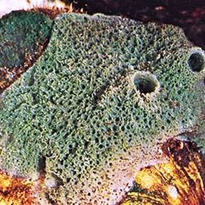
Sponges
The phylum Porifera, which contains the sponges, is a highly successful group of metazoan animals that includes about 8,600 living species of marine and freshwater forms as well as some that inhabit brackish waters. The majority are marine, but there are about 150 species of freshwater sponges, including twenty-seven to thirty species found in North America north of Mexico. The family Spongillidae is the most speciose and widespread group of freshwater sponges and includes twenty-two genera and more than 130 species from a wide variety of habitats. Seven species of freshwater sponges have been documented in Arkansas. Sponges are an ancient group of asymmetrical invertebrates with a fossil record preceding the early Cambrian period (541 million years ago), and even …
 Sponge
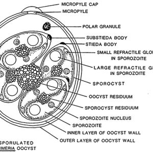 Sporulated Eimeria sp. Oocyst
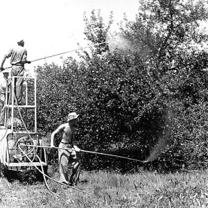 Spraying for Codling Moth
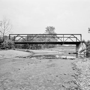
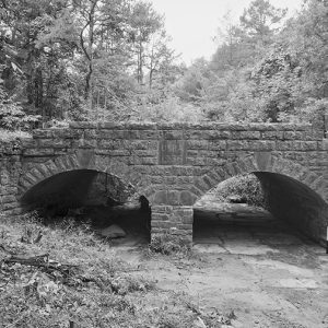 Spring Lake Bridge
Spring River
Flowing through northeastern Arkansas for approximately seventy-five miles in a southeastern direction, the Spring River empties into the Black River near Black Rock (Lawrence County). Mammoth Spring (Fulton County), adjacent to the Arkansas-Missouri state line, serves as the headwater for the Spring River. It expels more than nine million gallons of water each hour through a vent located eighty feet below the surface of Spring Lake, a low-turbidity body of water created by a dam downstream from the spring in what is now Mammoth Spring State Park. Although the water from the spring flows into the lake with great force, the vent’s depth prevents viewers on the surface from seeing the characteristic bubbling that springs typically produce. The consistent discharge …
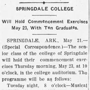 Springdale Commencement
 Springfield-Des Arc Bridge
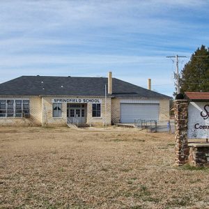 Springfield School
Springfield to Fayetteville Road
The Springfield to Fayetteville Road was built upon elaborate networks of horse trails that were likely established by the Osage. The trails extended into northwestern Arkansas and as Springfield, Missouri, was being established in southwestern Missouri in the late 1820s, settlers co-opted the established trails for their own use. The trail from Springfield to Fayetteville (Washington County) came to be called by that name and was established in 1835, totaling 146 miles. It was the major road prior to the 1838 establishment of what later became known as the Wire Road or Telegraph Road by the United States military. Also called Pioneer Road, the Springfield to Fayetteville Road was employed by the U.S. Army in 1838 to remove Native Americans …
 Springfield-Des Arc Bridge
Springfield–Des Arc Bridge
aka: Springfield Cadron Bridge
aka: Springfield Bridge
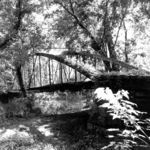
The Springfield Bridge is the oldest bridge in Arkansas, although it has been moved from its original location. It was erected in 1874 across the North Cadron Creek three miles east of Springfield (Conway County) on the Springfield–Des Arc Road. This early thoroughfare connected Des Arc (Prairie County), a thriving port for steamboat traffic on the White River, with Springfield, the county seat of Conway County from 1850 to 1873. Before the bridge was built, C. A. Simmons operated a ferry at the river crossing, charging five cents for a pedestrian, fifteen cents for a person on horseback, or seventy-five cents for a two-horse spring carriage. On November 8, 1871, Conway County awarded a contract to the King Bridge Company …
Springs
Springs are naturally occurring geologic features that transport emerging groundwater to the land surface. They also represent a transition from groundwater to surface water. This water can be released through one opening, multiple openings, or numerous seeps in the rock strata or soil. Springs have unique properties such as discrete habitats with relatively constant conditions like temperature, dissolved oxygen concentration, and flow. The underground reservoirs from which springs arise may be cavernicolous limestone, gravel, sand, sediment, soil, or other permeable formations. A spring’s presence depends on the nature and relationship of permeable and impermeable units, the position of the water table, and the land topography. Faults often play an important role in the location of springs by damming up an …
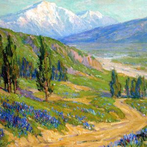 Springtime, San Gabriel Valley
 SS La Salle
 SS Masan
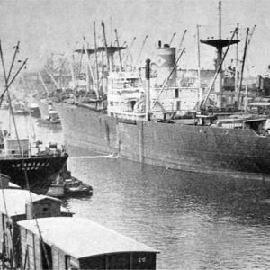
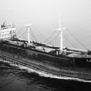
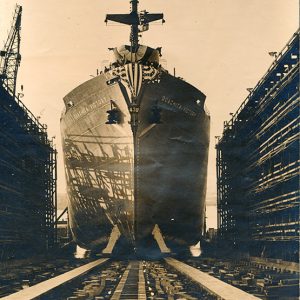
SS Ouachita Victory
The SS Ouachita Victory was a Victory ship launched on May 8, 1945, from Wilmington, California and named for Ouachita College (now Ouachita Baptist University). The title of SS stands for “steam ship” and should not be confused with USS, which signifies it as a “United States Ship.” Although it was used during World War II, the Ouachita was not associated with the United States Navy. The California Shipbuilding Corporation built the SS Ouachita Victory. The ship was 455 feet long and was composed of three decks. It could travel at a speed of fifteen knots. Lightly armed with small guns, Victory ships were never meant for battle. Their primary function was to transport cargo and troops. Only three victory …
 SS Ouachita Victory
St. Agnes Catholic Church
St. Agnes Catholic Church in Mena (Polk County) is the center of worship for St. Agnes Parish, which was established by Bishop Edward Fitzgerald in 1896. A temporary wooden structure first served the congregation, with a two-story frame building following. A new church building was completed in 1922, and St. Agnes Catholic Church was listed on the National Register of Historic Places in 1991, having retained all of its significant architectural and decorative features. Mena was incorporated as a township on September 18, 1896, as settlers began to flood into the area around the Kansas City Southern rail line. Within a month of Mena’s incorporation, Bishop Fitzgerald established the parish, and with the help of Father Patrick Enright of Fayetteville …
St. Andrew’s College
St. Andrew’s College, located near Fort Smith (Sebastian County), was the first attempt to found a Roman Catholic college in Arkansas. It was established in 1849 by Irish native Andrew Byrne, the first bishop of the Diocese of Little Rock. Byrne never had more than ten priests in Arkansas, and he maintained the Church with funds from the Austrian-based Leopoldine society and the French-based Society for the Propagation of the Faith. With this support, Byrne purchased land near Fort Smith to found the first Catholic college in Arkansas. When later incorporated into Fort Smith, the area was known as the “Catholic mile.” It was bordered on the north by Grand Avenue, on the south by Dodson Avenue, and on the east …
 St. Anthony's Hospital
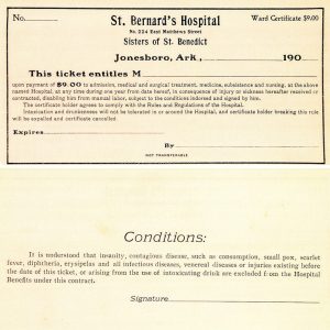 St. Bernards Medical Center Ticket
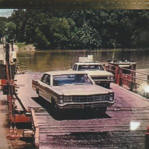
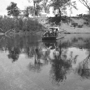 St. Charles Ferry
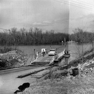 St. Charles Ferry
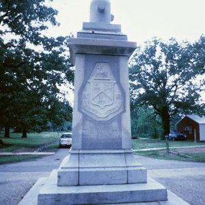
St. Charles Battle Monument
The St. Charles Battle Monument, located in the center of the intersection of Arkansas Street and Broadway in St. Charles (Arkansas County), is a commemorative monument erected in 1919 in honor of the casualties of the 1862 engagement at St. Charles. On June 17, 1862, a Union flotilla steamed up the White River to bring supplies to Major General Samuel R. Curtis’s Army of the Southwest, which was threatening Little Rock (Pulaski County) from eastern Arkansas. Confederate troops had sunk the gunboat CSS Maurepas and a pair of steamboats at St. Charles to block the river and placed cannon on shore to bombard any approaching vessels. The USS Mound City led the Union force. Around 10:00 a.m., a Confederate shell …
 St. Charles Battle Monument
 St. Charles Ferry
St. Edward Catholic Church
St. Edward Catholic Church is part of the second Catholic parish to be established in Little Rock (Pulaski County) and is located on the east side of the city. It began to accommodate increased German settlement in Arkansas during the 1870s and 1880s. Its first building was dedicated in August 1885 as St. Edward Catholic Church in honor of the patron saint of Little Rock bishop Edward Fitzgerald. A new building was built in the early 1900s, and there have been several renovations over the years; it was listed on the National Register of Historic Places in 1982. As more Hispanics moved to central Arkansas in the 1990s, St. Edward attracted these parishioners by giving sermons in Spanish. Growing oppression …
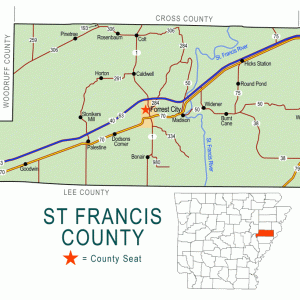 St. Francis County Map
St. Francis River
The St. Francis River originates in the northeast corner of Iron County, Missouri, and flows for twenty-five miles through the St. Francois Mountains, where it is a clear, fast-flowing whitewater stream until it reaches the Mississippi Alluvial Plain north of Poplar Bluff, Missouri, at which point the river becomes a sluggish, silt-laden stream. The river there turns south and travels 207 miles, forming the boundary between the Missouri bootheel and northeast Arkansas and then coursing between Crowley’s Ridge and the Mississippi River. The mouth of the St. Francis where it flows into the Mississippi is in the St. Francis National Forest just north of Helena-West Helena (Phillips County). The St. Francis River valley has been the site of human habitation …


