501-918-3025
calsfoundation@cals.org
calsfoundation@cals.org
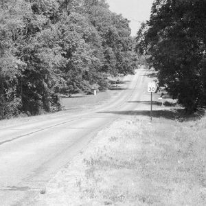
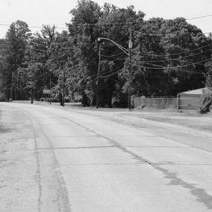
Originally constructed over several years in the 1920s and 1930s, U.S. Route 71 began serving as a major thoroughfare in western Arkansas. Bypassed by new construction between the 1950s and 1980s, what is now referred to as Old U.S. Route 71 has six sections listed on the National Register of Historic Places. Each section listed on the register continues to carry local traffic in the twenty-first century, which is a testament to the sturdiness of the construction.
The various sections of the road were constructed in a similar manner. Made of Bates-type concrete, the road surface includes tan stone mixed with concrete and laid over a wire frame. The road includes nine-foot-wide lanes that are separated by a four-and-a-half-inch-wide gap along the center line. When the road crosses the numerous bridges that still exist along its length, the gap is not present. Each section of the road is fifty feet long. The road does not include any shoulders. Parts constructed in low-lying areas prone to flooding rest on a dirt berm above the surrounding countryside.
From the south, the first section of road listed on the National Register is located in Ogden (Little River County). The section runs from south to north, beginning near modern U.S. Highway 71 and merging with East Ogden Road to form Grand Street. Continuing to the northwest, the section splits from Grand Street and follows Ogden Street. It then dead-ends with modern U.S. Highway 71. The section is approximately one-half mile in length.
It is unknown when construction of this section began. The Jefferson Highway did not follow the U.S. 71 route through Ogden when surveyors passed through the area in 1916. In the 1920s, the Arkansas State Highway Commission began to make incremental improvements on major highways throughout the state. The Ogden section of the highway was known as Section Four and was paved in 1940. The section connected Ogden and Index (Miller County) and measured 1.872 miles. With a winning bid of just over $59,000 for the project, including paving and engineering costs, the Flenniken Company from Shreveport, Louisiana, received the contract. The current highway to the east of the original section opened in 1970. This 1940 section was listed on the National Register on January 29, 2013.
The next section to the north is located in Ashdown (Little River County) and is used as a local street named North Park Avenue. Following the route of the section northward, it begins at the intersection of North Park and East Main Street. It continues northward, passing through three intersections with cross streets and a fourth intersection where another street forks to the north. The section ends near an intersection with modern U.S. Highway 71 on the north side of Ashdown.
This section of the road was paved in 1934 by A. C. Kennedy of Little Rock (Pulaski County). With a winning bid of $64,392.17, the company constructed 3.684 miles of grading, traffic service gravel, and drainage structures, as well as 1.5 miles of paving. With the construction of the modern U.S. Highway 71 to the west in 1965, the section began to be used as a city street. This section was listed on the National Register on January 29, 2013.
The final section in Little River County is located north of Wilton. Approximately two miles in length, the section also includes five bridges with concrete decks and reinforced pillars and metal girders.
This section of road was included in the original bid for the section constructed in Ashdown, with an additional bid covering 0.973 miles of roadwork including grading drainage structures, also awarded in 1934. It was bypassed in 1965 with the opening of the current highway to the west. This section was listed on the National Register on May 26, 2004.
Crossing the Little River at Wilton, the road continued in Sevier County, south of Ben Lomond. Today known as Ashley Camp Road, the section is approximately two and three-quarters of a mile in length. This section is notable for the three bridges included in the length of the road, constructed at the same time as the road. The exact cost and contractor of this section of road is unknown, although the work might have been completed by the same company that did the work near Wilton. This section was listed on the National Register on May 26, 2004.
Efforts to improve transportation in the area predate the construction of the highway by several decades. In 1912, a bridge was constructed over the Little River near the town, connecting it with Wilton. Four years later, the area received a survey for the construction of the Jefferson Highway, connecting Kansas City, Missouri, to Shreveport.
The bridges on the section of the road each cross overflow streams of the Little River. The southernmost bridge, located near the Little River, is constructed from concrete deck girders atop concrete piers. The sides of the bridge are constructed from cast-concrete pillars with two horizontal concrete beams connecting each pillar. The other three bridges are constructed with a reinforced concrete deck on top of metal girders. The bridges are set on concrete piers. The bridges were constructed by Kochtitzky and Johnson of Forrest City (St. Francis County), although the exact cost of the bridges on the surviving section is unknown.
After a new section of U.S. 71 opened to the west in 1965, the road remained in local use. While some patching has been conducted on the road, most of these repairs took place before the construction of the new road to the west, allowing this section to keep its original dimensions. The bridge across the Little River connecting this section with the section near Wilton no longer exists.
The next section of the road listed on the National Register is located near Jenny Lind (Sebastian County). Constructed in 1927–1929, the section is three-quarters of a mile in length. The first construction on the section began in late 1927 with the construction of drainage structures and grading work on a 15.309-mile section of the road. The contract for $78,110.80 was awarded to W. P. McCoy and Sons of Fort Smith (Sebastian County), which eventually received $87,832.77 for the work due to cost overruns. At the same time, construction began on several bridges on the road, including one on the section listed on the National Register. The contract for the bridges was awarded to the O’Hagan & McVicker Company of Kansas City. The paving of the section began in late 1928 with the Walter J. Bryson Paving Company of Jacksonville, Florida, receiving $268,121.62 for the work while the state provided $65,764.88 of materials.
The bridge on this section crosses a tributary of Bear Creek and is about fifteen feet long. The simple concrete slab has concrete curbs on each side. The current highway opened to the east in 1973. This section continues to be used as a local road, although a debris pile makes driving the entire length impossible. It was listed on the National Register on September 23, 2009.
The final section of the road is located in Greenland (Washington County). About three-quarters of a mile in length, the section was constructed in 1929–1930. The original bid for this section included work on 7.812 miles of road, which included the grading, drainage structures, and paving. The Porter Construction Company of Tulsa, Oklahoma, received the contract for $174,842, although the project eventually cost $178,369.35.
A separate contract for a total of eight bridges, including the bridge over the West Fork of the White River, was awarded in 1930 to the Maxwell Construction Company of Columbus, Kansas. The bridge consists of three Parker pony-trusses. The main span is 100 feet in length, with the other two spans measuring 104 feet each, giving the bridge a total length of 308 feet. Constructed with a steel deck covered in concrete, the bridge also includes concrete guardrails on either side of the structure. The section was replaced by the current highway in 1980. It continues to be used as a local road in the twenty-first century and was listed on the National Register on September 24, 2004.
For additional information:
“Old U.S. 71—Ashdown Segment.” National Register for Historic Places registration form. On file at Arkansas Historic Preservation Office, Little Rock, Arkansas. Online at http://www.arkansaspreservation.com/National-Register-Listings/PDF/LR0032.nr.pdf (accessed February 21, 2020).
“Old U.S. 71—Greenland Segment.” National Register for Historic Places registration form. On file at Arkansas Historic Preservation Office, Little Rock, Arkansas. Online at http://www.arkansaspreservation.com/National-Register-Listings/PDF/WA0922.nr.pdf (accessed February 21, 2020).
“Old U.S. 71—Jenny Lind Segment.” National Register for Historic Places registration form. On file at Arkansas Historic Preservation Office, Little Rock, Arkansas. Online at http://www.arkansaspreservation.com/National-Register-Listings/PDF/SB1016.nr.pdf (accessed February 21, 2020).
“Old U.S. 71—Little River Approach.” National Register for Historic Places registration form. On file at Arkansas Historic Preservation Office, Little Rock, Arkansas. Online at http://www.arkansaspreservation.com/National-Register-Listings/PDF/SV0090.nr.pdf (accessed February 21, 2020).
“Old U.S. 71—Ogden Segment.” National Register for Historic Places registration form. On file at Arkansas Historic Preservation Office, Little Rock, Arkansas. Online at http://www.arkansaspreservation.com/National-Register-Listings/PDF/LR0135.nr.pdf (accessed February 21, 2020).
“Old U.S. 71—Wilton Segment.” National Register for Historic Places registration form. On file at Arkansas Historic Preservation Office, Little Rock, Arkansas. Online at http://www.arkansaspreservation.com/National-Register-Listings/PDF/LR0078.nr.pdf (accessed February 21, 2020).
David Sesser
Henderson State University


Comments
No comments on this entry yet.