501-918-3025
calsfoundation@cals.org
calsfoundation@cals.org
| Latitude and Longitude: | 33°50’07″N 094°07’07″W |
|---|---|
| Elevation: | 463 feet |
| Area: | 3.92 square miles (2020 Census) |
| Population: | 140 (2020 Census) |
| Incorporation Date: | May 26, 1900 |
Historical Population as per the U.S. Census:
|
1810 |
1820 |
1830 |
1840 |
1850 |
1860 |
1870 |
1880 |
1890 |
1900 |
|
|---|---|---|---|---|---|---|---|---|---|---|
|
– |
– |
– |
– |
– |
– |
– |
– |
– |
– |
|
|
1910 |
1920 |
1930 |
1940 |
1950 |
1960 |
1970 |
1980 |
1990 |
2000 |
|
|
431 |
– |
– |
406 |
284 |
157 |
155 |
155 |
157 |
126 |
|
|
2010 |
2020 |
|
|
|
|
|
|
|
|
|
|
145 |
140 |
|
|
|
|
|
|
|
|
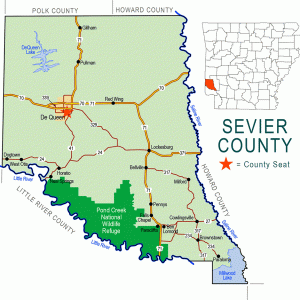
Ben Lomond is a small town in Sevier County. It is slightly east of U.S. Highway 59 and a few miles north of the Little River near where the river widens into Millwood Lake.
While the region now called Sevier County has been home for thousands of years to humans who hunted, fished, and gathered food, the region has always been sparsely populated. Some white settlers claimed land in the Little River valley as early as 1810; however, between 1820 and 1825, the Choctaw were settled on land in the area before being moved by treaty farther west into Indian Territory (now the state of Oklahoma). The site of Ben Lomond remained unclaimed until the middle of the nineteenth century, when settlers from Scotland—including Wiley and Mary McElroy and James Willson—arrived and named the hill location for a famous Scottish mountain.
In the years following the Civil War, more settlers came to southern Sevier County. Ben Lomond grew into one of the more important towns in the county, rivaling Paraclifta (Sevier County) and Lockesburg (Sevier County) in significance. In 1868, the oldest continuous post office in the county—known as Pine Woods from 1833 until 1846 and then renamed Brownstown—was moved to Ben Lomond. The town became an agricultural center, especially for cotton farmers. In some years, Choctaw would come from the west to work in the cotton fields during harvest season.
Several Ben Lomond residents had successful careers in county and state politics during the nineteenth century. A Union church was established representing several Christian groups, while the Church of Christ met separately. Thomas Dulaney, a Missionary Baptist minister and farmer, was one of the preachers who served the congregation. A Masonic lodge was also built, and a two-story schoolhouse served as many as fifty students.
The timber industry developed in the area during the 1880s. Lumber workers harvested pine, oak, cypress, hickory, ash, and cedar trees. Trapping animals for their fur was also profitable. Some farmers invested in cattle and hogs as well as cotton. Land was acquired for a Methodist congregation in 1895, which was formally organized in 1900. For a time, the church building was shared with other congregations.
Ben Lomond had a bank that opened late in the nineteenth century, but it went into receivership in the spring of 1909. A tornado caused damage to some barns in 1912, but no people were hurt. As schools were consolidated throughout Arkansas, the Ben Lomond schools became part of the Ashdown (Little River County) school district.
Ben Lomond is home to a senior center run by the Southwest Arkansas Development Council. The community has a post office and is served by five area churches, as well as a service station on Highway 59.
For additional information:
Sevier County Historical Society. The History of Sevier County and her People. Dallas, TX: Taylor Publishing Company, 1980.
Steven Teske
Butler Center for Arkansas Studies


Comments
No comments on this entry yet.