501-918-3025
calsfoundation@cals.org
calsfoundation@cals.org
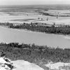
Cadron Ridge is a fifty-mile-long formation that runs from Beebe (White County) to the confluence of Cadron Creek west of Conway (Faulkner County). The ridge, a subsection of the Ouachita Mountains, reaches a height of 551 feet near Lower Ridge Road in Conway. The ridge then slowly loses elevation past the city of Conway until it reaches its western base. The six notable gaps along the ridge are Cadron, Roden Mill, Carmichael, Powell, Hinson, and House.
Like many of the geological formations in Faulkner County, Cadron Ridge is made from steeply dipping beds of Atoka sandstone. The Atoka strata consists of sandstone, shale, and calcareous sandstone beds.
Cadron Ridge takes its name from the creek running a few miles above the western base of the formation. The name’s origins are unclear, but whatever its genesis, it was used for one of the earliest settlements in Faulkner County, Cadron Settlement, as well as Cadron Cove (now Martinville), Cadron Gap, Cadron Valley, and the ridge. Many communities along the ridge were settled near the gaps such as Conway, Hamlet (Faulkner County), Beryl (Faulkner County), Vilonia (Faulkner County), and El Paso (White County).
The Cadron Ridge Baptist Church was organized in 1892 in a one-room log structure. In the twenty-first century, the church’s building is on Old Morrilton Highway, west of Salem Road and north of the Missouri Pacific Railroad tracks (now part of Union Pacific Railroad) that bisect Conway. Along with the early church, the school of Cadron Ridge was mentioned in local newspapers; by 1907, it had as many as forty-seven students enrolled per term.
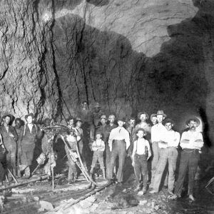
Before the twentieth century, the railroad neared the crest of the ridge, but the two-percent grade leading to it had severely limited the tonnage that could be hauled over the line. Plans were made to create a rail tunnel through the ridge to alleviate this issue, with its proposed location just over 500 yards west of the Cadron Ridge Baptist Church. By April 1902, sub-contractors had arrived in the area to create a tunnel through the ridge, and the multiple private firms at work on the task leased convicts from the state’s prison system for their labor. The tunnel was completed and usable by January 1904.
By 1910, concrete water reservoirs had been created on the ridge to transfer water from Cadron Creek to the city of Conway with the use of steel-bound wooden pipes. Going into the next decade, the city of Conway would improve the water system with new concrete settling basins and a filtration system. Water system improvements would continue through Cadron Ridge for the city well into the 1970s, with water tanks, pumps, and water lines being established.
In the late 1970s, an eighty-seven-foot microwave tower was constructed on the ridge as part of the Southwestern Bell Telephone Co. transmission system. The tower was used to bring educational television programs to the region, letting the station that became known as Arkansas PBS broadcast in color.
For additional information:
“37th Anniversary of Faulkner County Occurs Today, April 12.” Log Cabin Democrat, April 12, 1910, p. 4.
“Assessors Are Named.” Arkansas Democrat, August 24, 1910, p. 8.
“Cadron Ridge School Report.” Log Cabin Democrat, September 12, 1907, p. 5.
“Cadron Ridge TV Cable.” Hope Star, February 2, 1972, p. 2.
“Conway Receives Approval of EDA.” Batesville Guard, August 11, 1977, p. 6.
Faulkner County Historical Society. Faulkner County: Its Land and People Revisited. Conway, AR: Crossman Printing, 2021.
Gatewood, Robert L. Faulkner County, Arkansas 1778–1964. Conway, AR: The Faulkner Press, 1964.
“New Filtration System.” Arkansas Gazette, November 28, 1922, p. 2.
Pike, Freddie Raymond. “A History of the Cadron Ridge Baptist Church.” Faulkner Facts and Fiddlings 9, no. 4 (1967): 97–108.
Zane Brooks
University of Central Arkansas


Comments
No comments on this entry yet.