calsfoundation@cals.org
Bono (Craighead County)
| Latitude and Longitude: | 35º54’31″N 090º48’09″W |
| Elevation: | 265 feet |
| Area: | 2.66 square miles (2020 Census) |
| Population: | 2,409 (2020 Census) |
| Incorporation Date: | July 14, 1916 |
Historical Population as per the U.S. Census:
|
1810 |
1820 |
1830 |
1840 |
1850 |
1860 |
1870 |
1880 |
1890 |
1900 |
|
– |
– |
– |
– |
– |
– |
– |
– |
– |
– |
|
1910 |
1920 |
1930 |
1940 |
1950 |
1960 |
1970 |
1980 |
1990 |
2000 |
|
– |
– |
209 |
248 |
352 |
339 |
428 |
967 |
1,220 |
1,512 |
|
2010 |
2020 |
|
|
|
|
|
|
|
|
|
2,131 |
2,409 |
|
|
|
|
|
|
|
|
Bono, originally named Bonnerville, was established in the Big Creek Township, a community formed in Greene County before Craighead County was created in 1859. After the Kansas City, Fort Scott & Memphis Railroad (Frisco) erected a train stop near Big Creek, it became one of the county’s most important business centers during the late nineteenth century.
Big Creek Township, one of the oldest communities in Craighead County, was begun in 1837 by John Anderson and his son, who settled in the northwest part of the county. At that time, Big Creek Township included several small settlements, among them Trinity, Union Grove, Fifty-Six, and Paul’s Switch.
Oak Ridge was the site of a Delaware village. Native Americans, including a community of Shawnee and scattered Cherokee homesteaders, also were situated in northeast Arkansas. After the New Madrid earthquake of 1811–12, most of these settlers moved out of the area. The Cherokee in Arkansas (only a part of the larger Cherokee tribe) settled along the Arkansas River, but in 1828 they gave up their Arkansas lands for a tract west in what is now Oklahoma.
Prior to the railroad coming through Craighead County, the economy of the area was strictly agricultural. There were sawmills, gristmills, and cotton gins, but they were dependent upon local farmers for business. Most of these industries were powered by horses or oxen. All of the products milled or ginned were sold locally except for cotton, which was hauled to the nearest river and shipped to Memphis, Tennessee, or New Orleans, Louisiana, by steamboat. After the arrival of the railroad, the logging industry provided economic activity for the local residents.
One of the oldest churches near Bono in Craighead County, Old Trinity Methodist Church, was established in 1859 and served as a social center for many Bono residents. Worshipers traveled to services by wagon or horseback. Women entered the building through the north door and men through the south, and they sat on opposite sides during the services. Ministers rode a circuit that contained several churches and often received their salaries in fruit, vegetables, and meat.
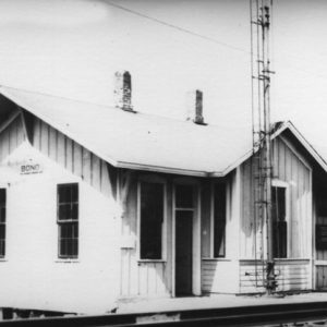
After the Frisco Railroad established a depot near the Big Creek Community in 1883, the trains brought more settlers, including preachers, gamblers, soldiers of fortune, and European immigrants. Railroads encouraged the development of small towns along their routes by offering cheap fares and sometimes selling railroad land to them. Engineers often stopped the train anywhere along the line to allow newcomers to step off.
With the influx of people, Alfred Bonner, an early settler and wealthy farmer, initiated a move to form a new town. Bonner donated the land for a post office in exchange for the town’s being named after him. He applied for a post office in Craighead County in early 1883. The Bonnerville post office operated unofficially from October 4, 1883, to February 4, 1884.
Postal authorities in Washington DC declined the application because Bonnerville was easily confused with the town named Booneville. They recommended changing the name, so residents held a contest and chose Bono. Postal authorities approved the name and established the Bono Post Office on November 20, 1884, with James M. Fisher as postmaster.
Bono originally consisted of a grocery store, a depot, a saloon, a commissary, several churches, section houses, a few shotgun houses, a few tents, a big tie yard, and a sawmill. As more people moved to the town, Bono evolved as a center of commerce. The Bono Mercantile Company, a general store established in 1911 by Berl Broome and George Lamb, served as a hub for trade and socialization. The store had a gossip bench and a spittoon out front, and it sold food, clothing, hardware, wagons, dry goods, and farm implements. A hand-powered elevator at the rear of the store moved merchandise between floors.
In the early years, children whose parents could afford the tuition attended subscription schools in the small communities around Bono. In the late nineteenth century, rural schools, including Fifty-Six School, Old Trinity School, Shiloh, and Lanieve, sprang up. In 1949, the State Wide Consolidation Referendum required rural schools to join the Bono School District, which was established in 1929. The school operated split sessions, dismissing during peak farming seasons to allow the children to help with planting and harvesting. Classes were in session from mid-November until the first of May and around July 15 until September 15.
In 1966, residents in the Craighead County communities of Bono, Cash, and Egypt approved by referendum a decision of the local people to consolidate their school districts. As a result, the West Side Consolidated School District was formed in the Herman community, a central location four miles west of Jonesboro (Craighead County). The school received international attention in March 1998 when two middle school students fired guns into a group of students and teachers who gathered outside the school in response to a fire alarm. The shooters killed four students and a teacher and wounded nine students and a teacher.
Bono is located in the lowlands west of Crowley’s Ridge, and as a result, flooding has plagued the town since its inception. Local leaders discussed the possibility of a watershed lake project to provide relief. The county’s willingness to help establish the watershed attracted the attention of the state’s congressional delegation. In February 2001, the Arkansas Game and Fish Commission bought 275 acres of timberland for construction of a 135-acre lake and 140-acre park and campground on the west side of Crowley’s Ridge; however, federal funds for the project did not materialize. By 2017, the lake had been built and in use for a few years, but funding for improvements continued to be a source of disagreement.
On August 4, 2024, a section of U.S. Highway 63 through Bono was closed so that pilots from the Little Rock Air Force Base could practice emergency landing and take-off.
For additional information:
City of Bono. bonoar.com (accessed July 19, 2023).
Stuck, Charles. The Story of Craighead County: A Narrative of People and Events in Northeast Arkansas. Jonesboro: The Hurley Company, 1960.
Williams, Harry Lee. The History of Craighead County. Little Rock: Parke-Harper Co., 1930.
Sherry Laymon
Bono, Arkansas


Comments
No comments on this entry yet.