calsfoundation@cals.org
Whittington Park Historic District
The Whittington Park Historic District in Hot Springs (Garland County) is located between West Mountain and Sugarloaf Mountain in the northwestern part of the city. This historic neighborhood was listed on the National Register of Historic Places on December 19, 2012, for its significance in community planning and development, ethnic heritage, and social history. It held an important place in the growth of Hot Springs as a health resort, while also reflecting the contributions of African Americans to the area’s health resort industry and serving as an exemplar of a successful racially diverse, working-class neighborhood. It further holds significance for its array of architectural styles, including Craftsman, Queen Anne, and ranch-style homes, as well as for evidence of the work of the Civilian Conservation Corps (CCC), a program of the New Deal in the 1930s.
The Whittington Park Historic District, featuring buildings that date back to 1896, is located on Whittington Avenue and Sabie Street between Water and Woodfin streets. Whittington Park, which forms the centerpiece of the neighborhood, is a tree-shaded urban greenway along Whittington Creek. The park and creek were named for early Hot Springs businessman Hiram Abiff Whittington.
Hot Springs prospered and grew between the 1880s and the 1960s, based in large part on the health resort industry centered upon the town’s reputation for healing waters. Wooden bathhouses along its main thoroughfare, Central Avenue, were replaced by elaborate structures on what became known as Bathhouse Row. This period of growth followed the resolution of land disputes in the 1870s between private citizens and the federal government over what was then called the Hot Springs Reservation.
The town was surveyed, and the renowned firm of Frederick Law Olmsted, designer of New York’s Central Park, was commissioned to design an overall landscape plan for Hot Springs. However, disputes between Olmsted and the U.S. Department of the Interior led the government to take over the plan. Included was the development of Whittington Lake Reserve Park, a project that turned out to be more complicated than expected.
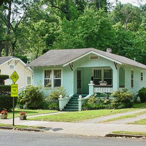
The park project also led to the development of a residential neighborhood surrounding the park. Single-family homes were built on both sides of the park; many of the Queen Anne–style residences remain today. The early 1900s saw the construction of smaller Craftsman-style bungalows. Many became rental properties for working-class families. Census records show most Whittington Park area residents as being employed in hotels and bathhouses as cooks, housekeepers, maids, managers, masseurs, porters, and waiters, with others working in construction and real estate.
West of the Whittington Park residential neighborhood, an amusement area sprang up in the early 1900s featuring an ostrich farm and alligator farm as well as a band pavilion, merry-go-rounds, roller coasters, and a venue for vaudeville shows. The attractions have generally been replaced by jogging paths and a tree-lined greenspace.
Census records of the 1920s indicate that the Whittington Avenue neighborhood was ethnically diverse, with white and black residents living side by side. Racial co-existence may have been fostered by the fact that many neighbors also worked together at the hotels and bathhouses.
The Great Depression of the 1930s saw New Deal agencies such as the CCC working in Hot Springs on such projects as enhancing the creek area in Whittington Park. This work, completed in 1943, can still be seen in the twenty-first century and is one of most characteristic features of Whittington Park.
The growing tourism industry of the late 1940s and 1950s brought Hot Springs increased prosperity as Americans were once again able to travel after the Great Depression and World War II. In 1946, almost one million baths were taken. More support staff was needed for the bathhouses and hotels. In the Whittington Avenue neighborhood, many small Craftsman bungalows, which had been popular since the 1920s, were replaced by ranch-style houses in the postwar era.
In 1956, James Dryden moved to Hot Springs from Kansas and converted a Whittington Avenue ice plant to a pottery-manufacturing facility, Dryden Pottery. This brought tourists to the neighborhood and set a somewhat artistic tone for the historic district.
However, in the 1960s, growth and prosperity began to decline in Hot Springs, including in the Whittington Park neighborhood. After the ostrich farm closed in 1953, the Whittington Park Historic District settled into life as a pleasant neighborhood around its signature greenspace.
For additional information:
Fuller, Ron. “A Memory of Whittington Avenue.” The Record 61 (2020): 7.1–7.19.
Hot Springs Whittington Park. National Park Service. http://www.nps.gov/hosp/learn/historyculture/whittington-park.htm (accessed November 24, 2020).
Silva, Rachel. “Arkansas Listings in the National Register of Historic Places.” Arkansas Historical Quarterly 73 (Autumn 2014): 322–330.
———. “The Whittington Park Historic District in Hot Springs.” The Record (2015): 10.1–10.12.
“Whittington Park Historic District.” National Register of Historic Places nomination form. On file at Arkansas Historic Preservation Program, Little Rock, Arkansas. Online at http://www.arkansaspreservation.com/National-Register-Listings/PDF/GA0866.nr.pdf (accessed November 24, 2020).
Nancy Hendricks
Garland County Historical Society

 Whittington Park Historic District
  Whittington Park Historic District


Comments
No comments on this entry yet.