501-918-3025
calsfoundation@cals.org
calsfoundation@cals.org
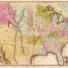
Telegraph Road in northwestern Arkansas was an important transportation thoroughfare of the nineteenth century, linking St. Louis, Missouri, with Fort Smith (Sebastian County). The road brought settlers, supplies, communication, and commerce to northwestern Arkansas.
Telegraph Road was initially built by the U.S. Army in 1828, thus starting its existence as a military road; it did not get the name Telegraph Road until a telegraph wire was strung along its path in 1860. The first travelers on the road were with the army, which moved supplies and mail between Springfield, Missouri, and the garrison at Fort Smith. Beginning in 1838, thousands of Native Americans traveled along the road in their forced removal from their ancestral homelands, during the Trail of Tears. Thousands of Native Americans camped in open fields north of the present-day visitors’ center at Pea Ridge National Military Park in their journey to Indian Territory. By the middle of the 1840s, the frontier had moved west. As a result, the army moved its men and operations out of the region.
Once California became a state in 1850, Congress wanted mail service that could get there in less than a month. John Butterfield’s contract of 1858 promised mail delivery from St. Louis to San Francisco, California, in less than a month. Butterfield’s route was to follow a southern, snow-free journey from Arkansas (along Telegraph Road) through Texas, into New Mexico, and then on to Yuma, Arizona. His journey, which concluded at San Francisco, spanned approximately 2,812 miles and 140 stations. The outbreak of the Civil War brought an end to the Butterfield stage’s twice-monthly runs.
In 1860, the first telegraph wire passed through the Ozark Mountains and was strung from Springfield to Fort Smith. The introduction of the telegraph brought the most enduring of names for the road—Telegraph Road and Wire Road—although telegraph communications ended less than a year after the wire went up, once Arkansas left the Union. The road has been called by many different names over the years such as the Military Road, Old Missouri Road, and Stage Road.
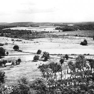
Telegraph Road brought two armies through northwestern Arkansas during the Civil War. The Union Army of the Southwest under the command of Samuel Ryan Curtis came to northwestern Arkansas in February 1862. Curtis and his army chased Confederate general Sterling Price down the road during his retreat to the Boston Mountains. The Confederate Army of the West, under the command of General Earl Van Dorn, sped into northwestern Arkansas as they marched sixty miles in three days. Van Dorn changed his plans of attacking Curtis in a frontal assault, as he was entrenched on the northern bluffs of Little Sugar Creek. Van Dorn decided to use another road, the Bentonville Detour from the south-southwest to the north-northeast, where it came to the confluence of Telegraph Road. Van Dorn then used Telegraph Road to come upon the flanks and rear of the Army of the Southwest at Little Sugar Creek. The Battle of Pea Ridge on March 7–8, 1862, was fought astride Telegraph Road.
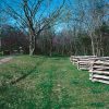
Telegraph Road was used throughout the war and beyond. Remnants of the road still exist in the twenty-first century in southwestern Missouri and northwestern Arkansas. Some of these remnants run throughout Wilson’s Creek National Battlefield Park and Pea Ridge National Military Park. Two sections of the Telegraph Road are listed in the National Register of Historic Places. The Springfield to Fayetteville Road, Cross Hollow Segment near Lowell (Benton County) was listed on January 19, 2005, and the Springfield to Fayetteville Road, Elkhorn Tavern Segment near Garfield (Benton County) was listed on May 26, 2005. Additionally, the Springfield to Fayetteville Road, Brightwater Segment near Brightwater (Benton County) was listed in the Arkansas Register of Historic Places on August 5, 2009.
For additional information:
Christ, Mark K., ed. Rugged and Sublime: The Civil War in Arkansas. Fayetteville: University of Arkansas Press, 1994.
DeBlack, Thomas A. With Fire and Sword, Arkansas, 1861–1874. Fayetteville: University of Arkansas Press, 2003.
Hess, Earl J., Richard W. Hatcher III, William Garrett, and William Shea. Wilson’s Creek, Pea Ridge, and Prairie Grove: A Battlefield Guide with a Section on the Wire Road. Lincoln: University of Nebraska Press, 2006.
Schultz, Robert G. The March to the River: From the Battle of Pea Ridge to Helena, Spring, 1862. Iowa City, IA: Camp Pope, 2014.
Shea, William, and Earl J. Hess. Pea Ridge: The Civil War Campaign in the West. Chapel Hill: University of North Carolina Press, 1994.
“Springfield to Fayetteville Road, Brightwater Segment.” Arkansas Register of Historic Places registration form. On file at Arkansas Historic Preservation Program, Little Rock, Arkansas. Online at http://www.arkansaspreservation.com/arkansas-register-listings/springfield-to-fayetteville-road-brightwater-segment (accessed October 1, 2020).
“Springfield to Fayetteville Road, Cross Hollow Segment.” National Register of Historic Places registration form. On file at Arkansas Historic Preservation Program, Little Rock, Arkansas. Online at http://www.arkansaspreservation.com/National-Register-Listings/PDF/BE3596.nr.pdf (accessed October 1, 2020).
“Springfield to Fayetteville Road, Elkhorn Tavern Segment.” National Register of Historic Places registration form. On file at Arkansas Historic Preservation Program, Little Rock, Arkansas. Online at http://www.arkansaspreservation.com/National-Register-Listings/PDF/BE3590.nr.pdf (accessed October 1, 2020).
Wood, Larry E. The Civil War on the Lower Kansas–Missouri Border. Joplin, MO: Hickory Press, 2003.
Kerry King Jones
Fayetteville, Arkansas


Comments
No comments on this entry yet.