
501-918-3025
calsfoundation@cals.org
calsfoundation@cals.org
The Little River starts in the St. Francis Mountains west of Cape Girardeau, Missouri, and flows southward through the Mississippi and Morehouse Lowland between Crowley’s Ridge to the west and Sikeston Ridge to the east. After crossing the Missouri-Arkansas state line, it enters the Big Lake National Wildlife Refuge near Manila (Mississippi County). Running a length of 148 miles, the Little River is a tributary of the St. Francis River, joining it at Marked Tree (Poinsett County). Before the New Madrid Earthquakes of 1811–1812, the Little River was a swift, free-flowing stream. In the twenty-first century, it is not much more than a series of stagnant mud holes due to the channeling and ditching of the Little River Drainage District.
The Little River emerged during the late Little Ice Age. The Wisconsinan Glacier covered much of North America about 12,000 years ago. Part of the melting drain-off from this glacier ran west of Crowley’s Ridge, later becoming the Mississippi River. Runoff going east of the ridge and west of Sikeston Ridge later became the Ohio River. After the two large rivers left the Crowley’s Ridge–Sikeston Ridge valley, the Little River replaced the drainage system for the area. Before the 1811–1812 earthquakes, the Little River was fed by the Whitewater River, which drained an area north of Cape Girardeau. Another northern feed for the Little River was the Castor River to the west of the Whitewater watershed. The two rivers joined to enter the Little River in New Madrid County near Canalou in Missouri. Farther south, Buffalo Creek and Varmey River joined the Little River to the St. Francis. In Arkansas, Honey Cypress Bayou also joined the two rivers not far from the state line.
West of Portageville, Missouri, a series of bayous joined the Mississippi to the Little River. Spanish Mills, with a trading post and grist mill, was established on the Little River. Flatboats traveled and traded up and down the Little River and made connection to the St. Francis River. However, the three major earthquakes of 1811–1812 changed that. Travel by flatboats to and on the Little River became impossible, and the connections to the St. Francis River had also disappeared. Falling trees and caving banks had blocked the river and bayous connecting them. Natural depressions made by the quakes soon filled with water, forming lakes and swamps.
Water could no longer move smoothly downstream through the Little River channel. The flow was forced out of the channel and spread through the hardwood forest lining the river bank. Yearly spring floods forced the water deeper into the woods. What had been small area of lowlands became major wetlands. The area became a swamp that extended into Arkansas.
In 1907, Himmelberger-Harrison Lumber and Land Company of Morehouse, Missouri, in a desire to ensure future timber for its operations, made a deal with the officials of New Madrid County. The company agreed to drain land for ownership of a percentage of each acre cleared. After some fumbling and a few false starts, an economical method of draining the land developed.
Himmelberger-Harrison’s early efforts draining New Madrid County later led to the development of the Little River Drainage District. Between 1914 and 1929, the district served an area ninety miles long and ten to twenty miles wide, draining an area made up of 540,000 acres to keep 1.2 million acres free of unwanted water. This was accomplished by digging 958 miles of ditches and building 304 miles of levee. The Little River Drainage District was the largest drainage district in the southern United States, moving more dirt than was moved to build the Panama Cannel. This pattern was followed when land in eastern Arkansas and western Mississippi was drained.
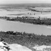
From New Madrid County to the point at which the Little River joins the St. Francis River, the waterway is part of the floodway system that is to serve as an overflow if needed to relieve pressure on the mainline Mississippi. The area is heavily channeled, with the Little River losing most of its identity. It leaves Missouri at the lowest point in the state, elevation 230 feet above sea level. In Arkansas, it enters Big Lake Wildlife Management Area, one of the Arkansas Game and Fish Commission (AGFC) areas that it shares with Big Lake National Wildlife Refuge.
The floodway leaving the Big Lake area is roughly one mile wide enclosed by ten-foot levees. Running through the floodway is Ditch No. 1, Ditch No. 9, Left Hand Chute of Little River, Right Hand Chute of Little River, and the Little River. These waterways run together, separate, and join again. The most dominant channel is the Right Hand Chute of Little River. Near the southern end of the St. Francis Sunken Lands Wildlife Management Area, the floodway enters the St. Francis River.
For additional information:
Fuller, Myron L. The New Madrid Earthquake. U.S. Geology Bulletin 494. 2nd ed. Cape Girardeau: Center for Earthquake Studies at Southeast Missouri State University, 1990.
Hock v. Little River Drainage District, 239 U. S 254 (1915). Justia.com http://supreme.justia.com/us/239/254/case.html (accessed September 21, 2025).
“The Little River Drainage District of Southeast Missouri, 1907–Present.” Cape Girardeau, MO: Little River Drainage District, 1989.
Stewart, David, and Ray Knox. The Earthquake America Forgot: 2,000 Temblors in Five Months…And It Will Happen Again! Marble Hill, MO: Gutenbert-Richter Publication, 1995.
Turner, Irving L., and Louis Unfer Jr. “Physiography of the Southeast Missouri Lowlands.” In Guidebook to the Geology in the Vicinity of Cape Girardeau, Missouri, Including Crowley’s Ridge, edited by Clayton H. Johnson. Cape Girardeau: Southeast Missouri State College, 1962.
Norman Vickers
Marion, Arkansas


Comments
No comments on this entry yet.