501-918-3025
calsfoundation@cals.org
calsfoundation@cals.org
| Latitude and Longitude: | 35°57’35″N 089°58’19″W |
|---|---|
| Elevation: | 250 feet |
| Area: | 1.67 square miles (2020 Census) |
| Population: | 2,910 (2020 Census) |
| Incorporated: | March 12, 1968 |
Historical population as per the U.S. Census:
|
1810 |
1820 |
1830 |
1840 |
1850 |
1860 |
1870 |
1880 |
1890 |
1900 |
|---|---|---|---|---|---|---|---|---|---|
|
– |
– |
– |
– |
– |
– |
– |
– |
– |
– |
|
1910 |
1920 |
1930 |
1940 |
1950 |
1960 |
1970 |
1980 |
1990 |
2000 |
|
– |
– |
– |
– |
– |
– |
1,386 |
3,215 |
3,783 |
3,968 |
|
2010 |
2020 |
|
|
|
|
|
|
|
|
|
3,548 |
2,910 |
|
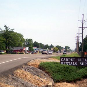
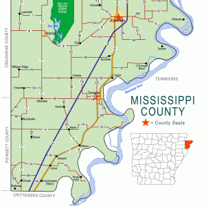
The city of Gosnell is a bedroom community near Blytheville (Mississippi County), a few miles south of the Missouri bootheel in northeastern Arkansas. The region was lightly populated in the late nineteenth and early twentieth centuries, and Gosnell grew only as a result of its proximity to Eaker Air Force Base, remaining unincorporated until 1968. It has hosted the Cotton Pickin’ Festival and Tractor Pull every fall since 1991.
Pre-European Exploration
Like much of the Delta region along the Mississippi River in Arkansas, the area that would become Gosnell was inhabited by various Native American tribes. A fifteen-foot mound built during the Mississippian Period (AD 900–1600) stands about two miles southeast of Gosnell. This mound is surrounded by a large late-prehistoric site and may have been the seat of a hereditary chief who ruled part of what is now Mississippi County. It was a major landmark for later settlers of the region. Many prehistoric sites are found along the course of the Pemiscot Bayou, including the Eaker archaeological site between Gosnell and Blytheville.
Early Statehood through the Gilded Age
The Gosnell region was surrounded by water in its early days. It is bordered on the west by Big Lake, which in the days before the automobile and railroads was used as a boat transportation route linking the settlement to the larger cities of Arkansas, Missouri, and Tennessee. Landowners along Big Lake took advantage of a thriving commercial hunting and fishing business. Pelts and packed fish could be shipped to market along the lake or by the two bayous to the Mississippi River.
To the east of the settlement is the Pemiscot Bayou. The road from Blytheville passed the Indian mound and store before traveling across the Pemiscot Bayou. Families with land along the Pemiscot traveled in boats into the Lumerate Bayou, which ran through Blytheville’s business district. The road to Gosnell came to be called the Pole Road. When stretches of the road became bad, the community would turn out to cut logs to place across the mud of the road, making it passable again.
Because the land was sparsely settled, it was of little concern to either side during the Civil War. All of Mississippi County had fewer than 4,000 residents at this time. Men from the area joined Confederate units from other parts of Arkansas. Aside from a few Union raids from Missouri, the county did not suffer much from the war.
Much of the land between Blytheville and Big Lake was purchased in the late 1800s by Lemael Gosnell, a dentist and pioneer farmer. In time, the community came to be named for him.
Early Twentieth Century
As late as 1902, the settlement was known as Chickasawba. In that year, the region was described in this way: “Fertile lands along down the banks of Pemiscot Bayou are rapidly being cleared and put in cultivation. This little place, though distinct today, is destined to one day become part of the city of Blytheville and form one of the most prosperous towns in the Basin.” Other settlers in the area called the community Stuff Town, apparently because of the store near the Indian mound where they purchased whatever goods they could not raise for themselves on their farms.
The land had also been heavily forested in the nineteenth century. The coming of railroads to Mississippi County made it possible for the hardwoods to be harvested, opening more land for cultivation of crops, primarily cotton. The floods of 1927 and 1937 prompted construction of a drainage system, which also opened more land for cotton cultivation. The Pemiscot Bayou was rerouted to connect with the drainage ditches, called “rivers” by the locals. A set of huge concrete locks and pumps was constructed to allow excess drainage from the Gosnell area to be pumped into Big Lake from the drainage ditch system. Although the Depression caused residents to struggle as much as it did elsewhere, improved conditions due to the increase of farmland helped to offset the difficulties.
World War II through the Faubus Era
World War II affected Gosnell more than had previous national events. The Blytheville Army Air Field, activated on June 10, 1942, brought many families and supporting businesses to the area. In addition to training pilots, part of the airfield also was used for a time to house German prisoners of war. The pilot training school was closed in October 1945, after the war ended, and the air base was closed in 1946. It was reactivated, however, in 1955 and continued to operate until 1992. Although the airfield was within the city limits of Blytheville, family housing constructed on the base in the 1950s was located within the Gosnell school district. Military dependants were bused to Gosnell for primary and secondary education, and federal funding helped to build new school facilities in the growing city.
In 1988, the name of the installation was changed to the Eaker Air Force Base. Throughout these years, military personnel continued to be heavily involved in the life of Gosnell, including its school system. Gosnell quickly grew into a bedroom community for the military and for people working in Blytheville industries.
Modern Era
Gosnell was incorporated as a first-class city on March 12, 1968. Gosnell’s first mayor after incorporation was Andy Bevill. Since then, Gosnell has had only two mayors: Carl Ledbetter and Dick Reams.
Eaker Air Force Base was closed in 1992. The Gosnell school system lost half of its enrollment as military personnel relocated. Throughout the county, unemployment increased and population fell. Over time, though, additional uses were found for the base. The Arkansas Aeroplex uses the existing runways and buildings for a number of businesses, including the Arkansas International Airport. A retirement community, a golf course, and a research station of the Arkansas Archeological Survey also use land from the former base. Around the beginning of the twenty-first century, Gosnell began to attract families from Blytheville’s new steel mills and related industries moving to the area. Gosnell remains a bedroom community for Blytheville.
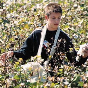
The town is known for its annual Cotton Pickin’ Festival and Tractor Pull. In the 1940s and 1950s, Blytheville had held the National Cotton Picking Contest. This festival lasted two days and featured a parade and a beauty pageant. Professional cotton pickers from around the country competed for cash prizes. Blytheville discontinued the festival in the 1960s because new technology made it unnecessary to pick cotton by hand. In 1991, Gosnell resurrected the festival to show a new generation what it was like to pick cotton by hand and to allow old-timers to show their proficiency. Gosnell’s primary industry is still cotton farming.
For additional information:
Mississippi County, Arkansas: Through The Years. Osceola, AR: Historic Heritage Documentation Committee, 1986.
Schulte, Bret. “A Rough Road Once the Pentagon Pulls the Plug.” U.S. News and World Report. May 23, 2005, p. 30.
Snowden, Deanna. Mississippi County, Arkansas: Appreciating the Past, Anticipating the Future. Little Rock: August House Inc., 1986.
Pat Lendennie
Blytheville, Arkansas
Staff of the Encyclopedia of Arkansas History & Culture


I have lived in Gosnell since 1972. I love it. I’m happy that I had the best of Gosnell. We had a good people in office who really loved the city and the people.