 Community Church in Garland
 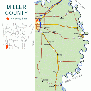 Miller County Map
 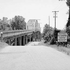 Red River Bridge
 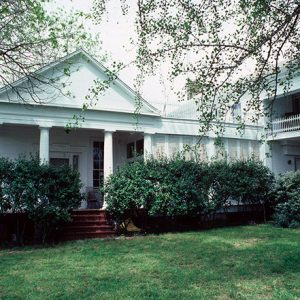 Wynn-Price House
 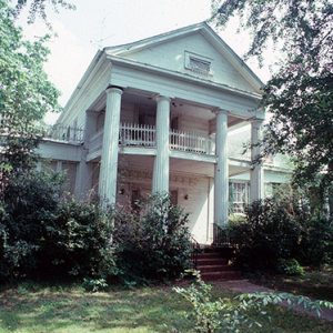 Wynn-Price House
501-918-3025
calsfoundation@cals.org
calsfoundation@cals.org
| Latitude and Longitude: | 33°21’46″N 093°42’36″W |
| Elevation: | 239 feet |
| Area: | 0.88 square miles (2020 Census) |
| Population: | 195 (2020 Census) |
| Incorporation Date: | January 19, 1904 |
Historical Population as per the U.S. Census:
|
1810 |
1820 |
1830 |
1840 |
1850 |
1860 |
1870 |
1880 |
1890 |
1900 |
|
– |
– |
– |
– |
– |
– |
– |
– |
– |
– |
|
1910 |
1920 |
1930 |
1940 |
1950 |
1960 |
1970 |
1980 |
1990 |
2000 |
|
277 |
370 |
425 |
325 |
351 |
377 |
321 |
660 |
415 |
352 |
|
2010 |
2020 |
|
|
|
|
|
|
|
|
|
242 |
195 |
|
|
|
|
|
|
|
|
The city of Garland is on the Red River in eastern Miller County. U.S. Highway 82 crosses the river at Garland, as do the tracks of the old Cotton Belt Railroad. The city is often referred to as “Garland City.”
The first and most famous resident of the area was William Wynn, who arrived at the banks of the Red River and established a farm around 1835. At that time, confusion about the border between Arkansas and Texas and uncertainty about the size of Miller County resulted in many records placing Wynn’s land in Lafayette County. Wynn bought many acres of land, on which he grew cotton and other crops. By 1850, according to census records, he owned ninety-six slaves.
Early in the 1850s, surveyors for the Mississippi, Ouachita, and Red River Railroad planned a crossing of the Red River at Wynn’s plantation. Tracks had not yet been completed that far west when Wynn died in 1857, and the Civil War then delayed construction of the railroad. Finally, by 1881, the St. Louis and Southwestern Railway (often called the Cotton Belt) built the proposed track, including a bridge across the Red River. A post office was established at the depot next to the bridge in 1883. According to a brief note in the June 1, 1882, Arkansas, Gazette, the community was named after Colonel Josiah Garland, the uncle of Rufus K. Garland and Augustus Hill Garland and a prominent landowner in the area.
Farm workers and railroad workers—many of them African American—settled in the growing community of Garland in the late nineteenth and early twentieth centuries. The cemetery where William Wynn had been buried became, ironically, an African American cemetery, associated with nearby Wynn Baptist Church; area whites were buried in nearby Lewisville (Lafayette County). The city of Garland was incorporated in 1904, probably to provide paved streets, water, and sewer service to the residents. In 1918, Troop Train No. 571, carrying soldiers from Waco, Texas, to St. Louis, Missouri, derailed near Garland, killing two and injuring several others.
In the 1920s, the State of Arkansas began to plan highways for motor traffic to link the various parts of the state. Arkansas Highway 2 was developed to run parallel to the border of Arkansas and Louisiana, connecting Texarkana (Miller County) with Lake Village (Chicot County). A bridge across the Red River was built in Garland a short distance north of the railroad bridge. Originally a gravel road, Highway 2 was paved by 1932. The next year, it was re-designated U.S. Highway 82.
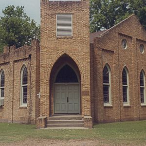
Garland was guided through the Great Depression in part by local businesswoman Charline Person, who had managed a nearby 5,000-acre plantation since her husband’s death in 1911. In 1926, she was featured at the Women’s National Exposition in St. Louis, Missouri. During the economic collapse, she took charge of soliciting and distributing goods as needed, as well as helping to raise funds to build the Garland Community Church.
After World War II, improvements to the highway resulted in new stretches of pavement for Highway 82, although the same bridge crossing was used. A portion of the older highway, three-quarters of a mile in length, has been preserved near Garland and is listed on the National Register of Historic Places.
The population of Garland has fluctuated, growing during the Depression, then slowly declining, surging to over 600 in 1980 before dropping back below 300 by 2010; the latter figure includes sixty-seven white citizens and 174 Black citizens. The population had fallen to 195 by 2020. Several businesses are located along the highway in Garland, including restaurants, a bar, a liquor store, a grocery store, a sand and gravel business, agricultural businesses, and a crop dusting company. Garland also has two Baptist churches. Southwest of Garland are two airports: Bill Rogers Airport at the edge of the city limits and Reed-Joseph Land Company Airport a short distance outside of town.
In June 2015, heavy flooding on the Red River resulted in the evacuation of Garland.
In addition to the strip of highway, the National Register of Historic Places also lists the antebellum Wynn-Price House, built by William Wynn and located near the Wynn Cemetery.
For additional information:
“Wynn Price House.” National Register of Historic Places nomination form. On file at Arkansas Historic Preservation Program, Little Rock, Arkansas. Online at https://www.arkansasheritage.com/arkansas-historic-preservation-program (accessed December 9, 2024).
“Wynns [sic] Cemetery.” RootsWeb.com. http://www.rootsweb.ancestry.com/~txkusa/Cemeteries/wynnscem.html (accessed December 9, 2024).
Steve Teske
Butler Center for Arkansas Studies


Comments
No comments on this entry yet.