501-918-3025
calsfoundation@cals.org
calsfoundation@cals.org
| Latitude and Longitude: | 35º55’27″N 094º11’18″W |
| Elevation: | 1,339 feet |
| Area: | 3.67 square miles (2020 Census) |
| Population: | 2,331 (2020 Census) |
| Incorporation Date: | May 18, 1885 |
Historical Population as per the U.S. Census:
|
1810 |
1820 |
1830 |
1840 |
1850 |
1860 |
1870 |
1880 |
1890 |
1900 |
|
– |
– |
– |
– |
– |
– |
– |
– |
– |
– |
|
1910 |
1920 |
1930 |
1940 |
1950 |
1960 |
1970 |
1980 |
1990 |
2000 |
|
– |
343 |
392 |
359 |
351 |
350 |
919 |
1,526 |
1,607 |
2,042 |
|
2010 |
2020 |
|
|
|
|
|
|
|
|
|
2,317 |
2,331 |
West Fork is a small community in Washington County lying south of Fayetteville along Interstate 49, Highway 71, and the White River. It functions primarily as a suburb of Fayetteville, with local churches, businesses, and a school system that serves many square miles of rural property. Established with the arrival of the railroad in 1885, West Fork has maintained a small-town existence without a significant role in Arkansas history.
Louisiana Purchase through Early Statehood
The name West Fork applied to at least two early settlements along the spring-fed headwaters of the west fork of the White River. Settlers arrived by 1828, creating self-sufficient homesteads farmed by extended family groups. The 1850 census for West Fork Township listed ninety-six households with trades including blacksmith, teacher, clergy, carpenter, miller, millwright, tanner, and wagon maker.
Civil War through the Gilded Age
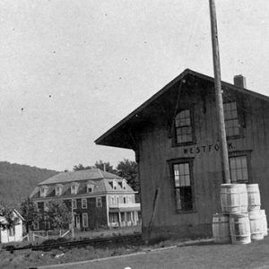
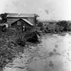
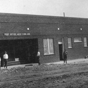
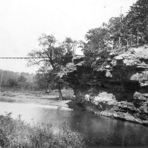
The present location is distinguished by a high bluff along the east side of the river, with the town site in a fertile valley west of the stream. It became the center of village life around 1876 with the construction of a water mill and steam mill across from the bluff. The first West Fork post office was established in 1848, four miles south at a small settlement alternatively named Woolsey and Pitkin, and was relocated to the “new” West Fork in 1878. Thomas McKnight was said to have laid out the town in 1883, which was incorporated in May of 1885, with J. M. Phillips as mayor.
West Fork Christian Church, followers of Alexander Campbell, organized in 1837, and Cumberland Presbyterian organized in 1853. Methodist and Baptist churches arrived soon afterwards, while Church of Christ, Jehovah’s Witness, and Pentecostal congregations were also present by the mid-twentieth century.
By the 1850s, West Fork Township included 605 white residents and no African Americans. In 1860, the population included 707 white and fifteen black residents, possibly slaves.
On April 27, 1861, a resolution unanimously endorsed by community leaders rejected secession of Arkansas from the Union. Guerrilla warfare rampant throughout the countryside during the Civil War resulted in loss of life and property among supporters of both sides; locals used caves to sleep, hide food, and secure possessions. More than twenty-five males from the West Fork area enlisted in the armies, possibly of both sides, while others joined the Home Guard.
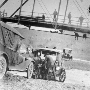
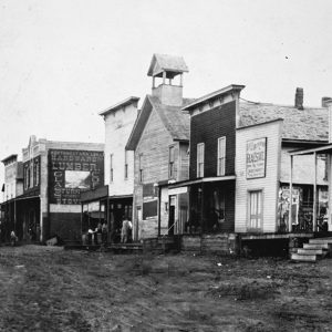
Early stagecoach lines followed a ridge to the west, but the arrival of the railroad along the river in 1882 brought a rush of settlers and enterprise. By the end of the 1880s, industries included timber products such as a wagon wheel spoke factory. A cannery employing thirty-seven workers specialized in canning tomatoes and evaporating apples grown locally. By 1900, the continuing logging and food production boom along the rail line added carpenters, a notary, and a shoemaker, as well as secret societies such as the Masons.
Early Twentieth Century
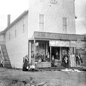
Even though this long valley, running twenty-two miles south of Fayetteville along the “Wyre road,” was noted in the 1880s as “the best belt for fruit growing” for the quality of its soil, productivity soon began to decline. A 1919 fire destroyed a block of downtown, and the forests had been logged, leaving the town poorly equipped for the oncoming Depression. The bank closed in 1924, and by this time, town life centered at Roy Karnes Drug Store with its prescription counter, soda fountain, gifts, tobacco products, and pool table.
Civilian Conservation Corps (CCC) workers arrived in 1933 to build a road from West Fork south to Devil’s Den State Park. Tourism at this state park then and now contributes to the town’s economy. By 1950, West Fork’s population—largely the descendants of settlers—saw no notable increase since 1920. Area industries included four canning plants, a lime rock crushing plant, a cabinet shop, several small hardwood sawmills, livestock, broiler production, and various crops.
Early subscription schools were replaced by a frame schoolhouse in 1879. Ongoing zeal for quality education led to a teachers’ institute in 1919 and the 1926 establishment of the state’s second chapter of the Parent Teacher Association. In 2005, the district served 1,158 students in a 131-square-mile area. West Fork school grounds also host the Boston Mountain Cooperative, headquarters to area school districts’ state and federal services.
World War II through the Modern Era
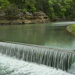
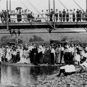
West Fork has retained a mayor/alderman form of government since establishment. Municipal water flowed in 1964, and a sewer system was installed in 1974. Most residents work outside of West Fork because the town hosts no major industry. Increased residential development has occurred since the 1999 completion of a four-lane highway along the ridge west of town, but the diversion of north-south traffic from old U.S. 71 has removed travelers from local commercial exposure, resulting in the loss of businesses along the old highway. About thirty-five businesses serve residents. A post office, city hall, public library, and the Frank Wenzel Community Center, named after a long-time school superintendent, are located in town, with swimming, fishing, a picnic pavilion, and a walking trail at Riverside Park across from the scenic bluffs. Visitors join locals to enjoy musical performances at the Little Ole Opry, held weekends in one of the few remaining 1880s structures.
For additional information:
History of Benton, Washington, Carroll, Madison, Crawford, Franklin, and Sebastian Counties, Arkansas. Chicago: The Goodspeed Publishing Company, 1889.
History of Washington County, Arkansas. Springdale: Shiloh Museum, 1989.
McNeil, Jack. “I Remember West Fork.” West Fork Library, West Fork, Arkansas.
Vertical Files on West Fork. Blair Library, Fayetteville, Arkansas.
Denele Campbell
West Fork, Arkansas


Comments
No comments on this entry yet.