501-918-3025
calsfoundation@cals.org
calsfoundation@cals.org
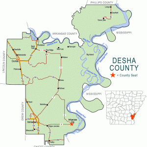
Yancopin of Desha County is a historic community marked by the only railroad bridge over the Arkansas River between Pine Bluff (Jefferson County) and the Mississippi River. The town at its peak had a railroad station, two churches, three stores, a post office, a cotton gin, and a small school for white children. Black students attended school in a church building after 1915 until a school was built for them in Watson (Desha County) around 1950.
Yancopin was never incorporated and was never really considered a “town.” It was, however, platted in the late 1800s after the former county seat, Napoleon (Desha County), was washed into the Mississippi River. The platted town was to be called New Napoleon, but lots were never sold and the town never built. The area nearby that would become Yancopin was populated with plantation owners and both white and Black tenant farmers and sharecroppers. When bridge construction began in 1903, many workers also lived there in railroad cars supplied them by the railroad.
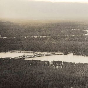
Yancopin is uniquely situated on the Arkansas River, which continues to meander approximately twenty miles before emptying into the Mississippi River. The railroad bridge was constructed to cross not only the Arkansas River but also the White River a few miles north. After the bridge was completed, train service began in 1906. A bridge tender was employed to raise and lower a bridge section to allow steamboats to pass under. The bridge was long and high, a marvel of its time in the area. One writer commented that crossing the bridge was like crossing the Pontchartrain Bridge in Louisiana. (However, sometime before 1960, the bridge underpinnings in the swampy land between the White and Arkansas rivers were filled with soil so that, as of 2012, it appears more like a built-up railroad bed than a connecting bridge.) Rail transportation opened the interior of eastern Arkansas to population and economic growth. However, it doomed steamboat traffic to a slow decline. The area around Yancopin was an important steamboat landing, not only because of its location on the Arkansas River but due to the close proximity to the White River Cutoff.
There are two legends regarding how Yancopin was named. The first is the fact that the swampy area was covered by a water lily called the “chinquapin” by the Quapaw Indians living in the area. “Yancopin” is a corruption of the Quapaw word “chinquapin.”
The second legend was handed down by people living in the area during the Civil War. The area around what would be called Yancopin was very important during the war because the Arkansas River, as well as the nearby Mississippi and White rivers, was patrolled by both Union and Confederate forces. The Confederate army built a stockade for captured Union soldiers in the area. Therefore, the name “Yankee-pen” became “Yancopin.”
The Missouri Pacific Railroad ceased operations in the area, and the post office closed in 1958. Farm mechanization at that time eliminated the need for farm laborers.
In the twenty-first century, the Delta Heritage Trail south of the Arkansas River will begin at Yancopin as state funds become available to build the trail. As of 2012, there are no residents in the area, which is now owned by the Arkansas Department of Parks and Tourism. A park ranger headquarters is on the site.
For additional information:
Dobson, Eugene, and Merritt, James. “Yancopin.” Desha County Historical Society 1983 Programs 10 (Spring 1984): 25–40.
Helen Pennington
Pine Bluff, Arkansas


Excellent article. My mother was born and raised in Yancopin, and for years, I was told the story of how and why Yancopin was started. I was always led to believe that it was a prison for Union troops, but I stand corrected.
The town of Yancopin was surveyed into blocks and lots in April 1925 by J. C. Peoples, filed at the courthouse in Arkansas City, Arkansas, on July 7, 1925. James M. Scales bought all but two lots on the east side of the railroad tracks, a store, houses, and other buildings on the property. The Massey Brothers had built the store and J. M. Scales had worked for them until he bought it. J. M. Scales also bought the property on the west side of the tracks, except the Austin lot where the store and house are. The Austins bought the two lots on the east side. J. M. Scales ran the Scales Store until he died in 1951. After that, the family kept it open until about 1956. The Scales heirs have owned the land since that time. Mike Moncrief, a great-grandson of J. M. Scales, lives on the land now.