

501-918-3025
calsfoundation@cals.org
calsfoundation@cals.org
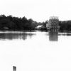
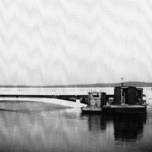
North Fork River drains an area of about 1,830 square miles in Missouri and Arkansas and is about 110 miles long. Its headwaters begin in Wright County, Missouri, near the town of Mountain Grove. From there, it flows generally south through Douglas and Ozark counties, Missouri. About the last half of its length is in Baxter County, Arkansas. The U.S. Army Corps of Engineers impounded the North Fork with the construction of Norfork Dam near the town of Norfork (Baxter County). Norfork Dam was the first of several Corps of Engineers flood control and hydropower dams on the White River and its tributaries.
Variant names for the river have included Big or Great North Fork of White River, North Fork White River, and North Fork of White River. Below Norfork Dam, the remaining 4.8-mile stretch of river is referred to as the Norfork tailwater. There is an upstream tributary of the White River farther west called the Little North Fork of the White River, but the lower third of it is now encompassed by Bull Shoals Lake in Marion County.
Native Americans occupied most of the Ozark Plateau since approximately 10,000 BC. In the historical period, the Osage were known to travel through the area seasonally, hunting game. Cherokee, Delaware, and Shawnee also settled in the area as their tribes continued to be pushed farther west.
Beginning in November 1818, Henry Schoolcraft and his traveling companion, Levi Pettibone, followed almost the entire course of the North Fork to within ten miles of its confluence with the White, thinking they were on the White River itself. Schoolcraft describes the limestone and dolomite geology, springs, clear water, and abundant game he saw along the river. At times, they had to travel parallel to the river at some distance from it because of the steepness of the terrain and the thickness of the vegetation and cane. The Missouri section of the river has an average gradient of 12.8 feet per mile.
Jacob Wolf’s house at the confluence of the North Fork and the White established an early trading influence. However, actual settlements on the North Fork were relatively few. In Arkansas, a notable one was Henderson (Baxter County). The large tributaries of Big Creek and Bennett’s Bayou also saw some settlement. By the end of the 1800s, small subsistence farms grew cotton, corn, wheat, and livestock throughout the river valley, but periodic floods made life hard for these settlers and their families. Economic prosperity came to the area only after lake impoundments, road improvements, and rural electricity created a tourism and real estate industry.
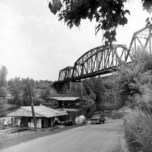
The river and Bryant Creek (its parallel tributary in Missouri) were the location of numerous water power mills before the Civil War. The Geological Survey of Arkansas (now the Arkansas Geological Survey) published a report in 1911 listing the North Fork River as a potential water power site. From its confluence with the White to Henderson, the river contained numerous rapids such as Buzzard Roost Falls. As a result, the river was not considered navigable, nor was it used extensively for floating timber, but its steepness and high rate of flow did make it a good candidate for a flood-control and hydropower project.
A United States Geological Survey study in 1968 concluded that much of the flow of the North Fork comes from groundwater runoff. Besides the groundwater and spring influences from Bryant Creek, there exist numerous sinkholes to the northeast of the basin. This perhaps explains how the flow of the North Fork is almost twice that of Bryant Creek or other regional streams.
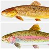
The lake impoundment has meant the loss of diversity to the biotic community, but stocking programs have provided a variety of bass, sunfish, and other fish species to anglers. Releases from Norfork Dam recharge the river with cold water and extend suitable trout habitat into the White River about fifty miles, and a national trout hatchery is situated below the dam. The lake is also an important stop for waterfowl in the Mississippi flyway.
Minimum flow has been approved below Norfork Dam, and construction of a siphon will provide a continual release of cold water during periods of non-generation. The additional flow is designed to increase temperature stability and wetted perimeter for trout habitat. However, water released from the reservoir in the late summer and fall has very low dissolved oxygen concentrations, and numerous fish kills have been documented. Local, state, and federal agencies have yet to come to an agreement on how to solve the problem. As of 2010, both the Norfork tailwater and the first few miles of the White River downstream from Bull Shoals Dam are listed as Arkansas impaired waters under the 303(d) Clean Water Act provisions.
For additional information:
Benke, Arthur C., and Colbert E. Cushing, eds. Rivers of North America. Amsterdam: Elsevier/Academic Press, 2005.
Messick, Mary Ann. The History of Baxter County, 1873–1973. Mountain Home, AR: Mountain Home Chamber of Commerce, 1973.
Schoolcraft, Henry Rowe. Rude Pursuits and Rugged Peaks: Schoolcraft’s Ozark Journal, 1818–1819. Fayetteville: University of Arkansas Press, 1996.
Shiras, Frances H. History of Baxter County. Mountain Home, AR: J. W. Daniel and Shiras Bros. Print Shop, 1939.
Skelton, John, and E. J. Harvey. “Structural Controls on Streamflow in the North Fork River and Bryant Creek Basin, Missouri.” Geological Survey Research 1968. U.S. Geological Survey Professional Paper 600-C, C153-C157.
Wallis, Frank. “Officials to Sign Lake Properties Agreement.” Baxter Bulletin. July 8, 2010, pp. 1A, 10A.
Scott Branyan
Rogers, Arkansas


Comments
No comments on this entry yet.