501-918-3025
calsfoundation@cals.org
calsfoundation@cals.org
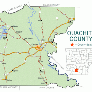
Miller’s Bluff is an unincorporated community located in Ouachita County along the Ouachita River. Located in the southeast corner of the county, Miller’s Bluff is about five miles north of Norphlet (Union County), six miles northeast of Smackover (Union County), and seventeen miles southeast of the county seat of Camden (Ouachita County). The community is directly across the river from Calhoun County.
The Hunter-Dunbar Expedition passed the future site of the community while exploring the Ouachita River valley in 1804 and 1805 but did not make any special notes of the area. The community is named for an early settler (although the exact details including the settler’s first name are not recorded). Early settlers in the area include Anderson Farris, who obtained just over ninety-five acres in both Ouachita and Calhoun counties in 1848. The following year, he obtained about seventy-five more. Farris received 240 more in 1860 by using bounties paid to Captain Stephenson’s Company of Illinois Militia. In 1860, the Kentucky-born Farris owned about $10,000 worth of real estate while having a personal estate valued at $20,000. This included seventeen slaves. Farris farmed and worked as a physician. His first wife, Sarah Farrell Farris, died in early 1860, just a year after marrying Farris, who would marry two more times before his death in 1889.
Other early landowners in the area included Alexander Moore, who obtained eighty acres in 1859. The last patent issued in the area went to Thomas Reynolds in 1916 for just under fifty-eight acres.
In the early and mid-twentieth century, the area became a popular recreation area for citizens of Camden, Smackover, and other nearby towns, although several drownings occurred over the years.
The area became popular with workers in the nearby oil fields, as numerous moonshine stills operated there during the 1920s. At least one saloon operated in Miller’s Bluff in January 1927 when it was raided by the Ouachita County sheriff, leading to the deaths of a deputy sheriff and one moonshiner. Another raid in October of the same year in Miller’s Bluff led to the deaths of two more bootleggers. Excursions down the river for pleasure cruises from Camden received coverage in local newspapers at the height of Prohibition, although reports specifically denied that any drinking occurred.
Operations to drill for oil began in the Miller’s Bluff area in 1936 when a test well was dug by the Proetz and Brown Company. A ferry opened in the community in May 1936 to support oil operations. With the opening of the ferry, the approach roads on both sides of the river were also upgraded. Other business operations included the dredging of the bottom of the river to gather gravel. In the early 1960s, plans to build a paper mill and a chemical plant near the community were discussed, and although some infrastructure to support these facilities was constructed, the businesses did not open. A post office never operated in the community.
In the twenty-first century, Miller’s Bluff has no businesses and only a few scattered homes. A terminal for the shipment of oil is located on the river near the community. The land is heavily timbered and swampy. The Farris Family Cemetery is located in the community.
For additional information:
“Another Oil Boom Forecast.” Camden News, May 27, 1936, p. 6.
Benson, Ronnie. “Gunfight at Miller’s Bluff.” Ouachita County Historical Quarterly 25 (Winter 1993): 18–25.
“Community Clinic Planned for Camden on May 8 and 9.” Camden News, April 15, 1962, p. 1.
“Descendent of Early Camden Family Lists Historical Data.” Camden News, June 12, 1948, p. 21-C.
“Ferry Operates for New Field.” Camden News, May 22, 1936, p. 1.
“Many Attend Boat Excursion.” Camden News, June 21, 1930, p.
“Mechanic Is River Victim.” Camden News, July 5, 1939, p. 1.
“Permits Sought to Dredge Gravel.” Camden News, June 19, 1963, p. 1.
David Sesser
Henderson State University


Comments
No comments on this entry yet.