

501-918-3025
calsfoundation@cals.org
calsfoundation@cals.org
Both Confederate and Union forces constructed fortifications to protect Arkansas’s capital between 1863 and 1865, with the Confederates concentrating their efforts on the north side of the river while Union works were built primarily south of Little Rock (Pulaski County).
Following the Confederate defeat in the July 4, 1863, Battle of Helena, most of the Confederate troops in the state fell back to central Arkansas and braced for a Union offensive toward Little Rock. Major General Sterling Price reported that, in late July, “I commenced the construction of a line of rifle-pits and other defensive works on the north side of the Arkansas [River], and pushed them forward to completion as rapidly as I could.” The works stretched from Big Rock, where modern-day Fort Logan H. Roots is located, to several miles east of the high ground, which later became the location of the Park Hill neighborhood in North Little Rock (Pulaski County).
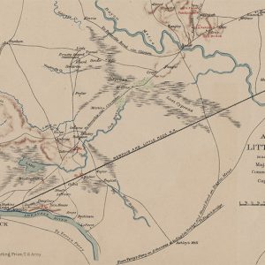
A period Confederate map illustrates three main fortifications protecting the expected Federal route of approach north of the river. Redoubt No. 1 was sited south of the Memphis and Little Rock Railroad tracks in order to block the road to Little Rock that followed the river. Redoubt No. 2 was constructed northeast of No. 1 and covered the railroad line, and Redoubt No. 3 was built north of No. 2 at the Galloway place above Ink Bayou to guard the Memphis to Little Rock Road itself.
Construction on the Confederate works continued into September, and by September 7, a Confederate officer reported that “our works extend from the river two miles below the city, to the eastern part of Crystal Hill, a distance of about six miles. Gen’l Fagan’s brigade is on the extreme right, Parsons on Fagan’s left, Frost in the center and McRae on the left.” Major General Frederick Steele, however, declined to use his Union troops against the prepared works and instead crossed his cavalry over the Arkansas River below Little Rock on the morning of September 10 to flank the Rebel works, leading Price to order his men to abandon their fortifications and retreat to southwestern Arkansas.
With the capture of Little Rock, Steele ordered fortifications constructed to block possible Confederate sorties against the capital from the southwest. By early November, construction was well underway on a large, square redoubt at a site roughly bounded by modern-day 15th, 16th, Gaines, and Arch streets in Little Rock. That redoubt, dubbed Fort Steele, was completed by late December 1863. Other major redoubts were built near Hanger Hill at the end of 9th Street and on high ground near the intersection of 21st and Cumberland streets.
Following the repulse of Steele’s excursion toward Louisiana in the spring of 1864, Federal troops labored to improve Little Rock’s fortifications, constructing rifle pits between the major redoubts and felling timber to create clear fields of fire against any Confederate offensives against the capital. Union maps from 1864 show at least seven redoubts surrounding Little Rock, while another was built north of the Arkansas River to protect the Memphis and Little Rock Railroad’s engine house in the vicinity of today’s Simmons Bank Arena. Steele deemed the works nearly done by late November 1864, and Union engineer Junius B. Wheeler wrote, “The extent of front to be protected at Little Rock is about four miles. A square redoubt with counterscarp galleries [Fort Steele] forms the key of the position. This redoubt mounts eight guns, six of which are 20-pounder Parrotts; rifle-pits, batteries, &c, flank it.” Confederate troops would never challenge these works.
While newspaper reports stated that remnants of some of the Confederate and Union fortifications built to protect Little Rock survived into the 1930s, no above-ground evidence of the elaborate system of earthworks is known to remain.
For additional information:
Allen, A. Hall. “Little Rock Was Ringed By Fortifications.” Arkansas Democrat, June 20, 1965, pp. 59–60.
Christ, Mark K. Civil War Arkansas 1863: The Battle for a State (Norman: University of Oklahoma Press, 2010).
———. “‘Well-built and formidable’: Fortifying Little Rock, 1863–1865.” Pulaski County Historical Review 62 (Spring 2014): 16–21.
Sherwood, Diane. “Forts of the Civil War.” Arkansas Gazette Magazine Section, December 11, 1938, p. 1.
Mark K. Christ
Little Rock, Arkansas


I lived as a child at 221 E. 22nd St. in Little Rock, and our backyard contained part of a trench, probably no more than 30 feet or so, running on a north-south axis. But the best part was to the south of us in Mr. Langhoerst’s backyard, contiguous to our own. He was a Spanish-American War veteran, and his huge house still stands (I think) facing Cumberland. Atop the highest part of his backyard was a very strange square earthen structure. Although he used this as a garden, you could still see (especially in winter) that something else had been there. I would suggest that this might have been the remnants of a small redoubt. I have not seen any of this since we moved to Texas in 1969, but who knows–perhaps it is still there. Also note that this location coincides with a crude map of Union fortifications published in the Gazette around 1966.