


501-918-3025
calsfoundation@cals.org
calsfoundation@cals.org
Running through southeastern Missouri and northeastern Arkansas, the Little Black River is a small stream that empties into the Current River. The Current drains into the White River, which in turn drains into the Mississippi River. The Little Black River is used for agricultural purposes and flows into the Current River about five miles south of the Missouri state line, making it one of the shortest rivers in Arkansas.
The stream begins in Ripley County, Missouri, near the community of Flatwoods. The North and South Prongs of the Little Black come together at that location. The South Prong of the river begins in Carter County and is joined by Sanders Creek in the Mark Twain National Forest. The North Prong rises in Carter County north of Hunter, Missouri. As it flows south, the stream is joined by multiple creeks, most notably by the Middle Fork of the North Prong just east of Grandin, Missouri. Flowing to the southeast, the river enters Butler County near Bonanza Hollow and crosses U.S. Highway 160 east of Fairdealing, Missouri. The river turns to the south, followed by a change to the southwest. It reenters Ripley County, and multiple streams join the river as it flows toward Arkansas.
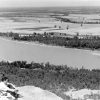
Entering Clay County in Arkansas, the river flows southward and is joined by Cypress Ditch less than two miles from the state line. It flows west of Success (Clay County) and crosses Arkansas Highway 328. North of Success, Cypress Ditch joins the river. Moving to the southwest, the river flows into the Current River less than three miles from Success. Just before joining the Current, Black Creek empties into the Little Black River. The junction of the two rivers occurs on the east bank of the Current River in Clay County, while the west bank of the Current at that location is in Randolph County. The mouth of the Little Black River is about two and a half miles northwest of Datto (Clay County).
Prehistoric settlement of the area occurred as part of the Powers Phase. Part of Middle Mississippian culture around AD 1300, the phase was centered on the Little Black River and extended to the St. Francis River.
Early descriptions of the area around the river include Louis Bringier’s 1821 article in the American Journal of Science and Art, based on observations he recorded in 1812. He wrote that the area between the head waters of the Big Black and the Little Black, as well as the White River, was rich in saltpeter or potassium nitrate. George Engelmann wrote about the area just south of the river in 1837 while on a trip from St. Louis to Little Rock (Pulaski County). He particularly noted the appearance of tulip trees, the first he viewed west of the Mississippi River.
Early settlers along the river in Arkansas included veterans of the War of 1812 who received land grants for their service. Other settlers purchased grants from these veterans and moved to the area. There has been little development on the river other than the establishment of small-scale farms. The river is not dammed, and the short length of the stream would not make such a project practical.
In the early twenty-first century, the river in Arkansas is surrounded by farmland and forests. Water from the Little Black is available for agricultural work, and it is not heavily used for recreation or other activities.
For additional information:
Black, Thomas K. “Middle Mississippian Cemeteries.” In The Biological and Social Analyses of a Mississippian Cemetery from Southeast Missouri: The Turner Site, 23BU21A. Ann Arbor: University of Michigan Press, 1979.
Jansma, Jerome, Harriet H. Jansma, and George Engelmann. “George Engelmann in Arkansas Territory.” Arkansas Historical Quarterly 50 (Autumn 1991): 225–248.
“Little Black River at Success, AR.” United States Geological Survey. https://waterdata.usgs.gov/monitoring-location/07068600/#period=P1Y&showMedian=true (accessed April 29, 2025).
“Summary Report – Little Black River.” United States Geological Survey. https://edits.nationalmap.gov/apps/gaz-domestic/public/search/names/51200 (accessed April 29, 2025).
Williams, W. D. “Louis Bringier and His Description of Arkansas in 1812.” Arkansas Historical Quarterly 48 (Summer 1989): 108–136.
David Sesser
Southeastern Louisiana University


Comments
No comments on this entry yet.