

501-918-3025
calsfoundation@cals.org
calsfoundation@cals.org
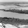
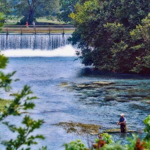
Flowing through northeastern Arkansas for approximately seventy-five miles in a southeastern direction, the Spring River empties into the Black River near Black Rock (Lawrence County). Mammoth Spring (Fulton County), adjacent to the Arkansas-Missouri state line, serves as the headwater for the Spring River. It expels more than nine million gallons of water each hour through a vent located eighty feet below the surface of Spring Lake, a low-turbidity body of water created by a dam downstream from the spring in what is now Mammoth Spring State Park. Although the water from the spring flows into the lake with great force, the vent’s depth prevents viewers on the surface from seeing the characteristic bubbling that springs typically produce. The consistent discharge at the lake’s bottom keeps the river above a minimum depth year-round.
The Spring River is joined several miles downstream by the South Fork, which flows eastward from its origin near Salem (Fulton County). As it is not fed by Mammoth Spring, the South Fork of the Spring River carries a less consistent volume of water and sometimes is not suitable for canoeing during late summer and early fall; however, its extensive gravel bars provide good sites for camping and picnicking.
The constant supply of cold, clear water provided by this river and its tributary creeks, along with the rich alluvial soil built by the regular flooding from heavy rainfall, attracted populations to the area from the first human discovery. The early inhabitants were the Native Americans who hunted, fished, and maintained camps and villages in the valley between the river and the rocky bluffs and the tree-covered hills flanking both sides of the stream. Artifacts and burial sites can still readily be found after each flood in the fields along the banks. Some of these inhabitants must have remained until the early 1800s, for oral tradition is that the first white arrivals found fires still burning from the last Indians to leave.
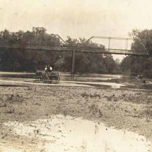
The first white discovery and settlement began soon after the end of the War of 1812, when a party searching for a fertile river valley for farming came to what was then Lawrence County in 1816. One member, John Crawford, left home in 1818 with two dogs for a hunting trip in the “Spring River Wilderness.” After ten days, his dogs returned without him, and his body was never discovered. His family and four others, however, had settled in the Spring River valley by the 1820s on land near the present location of Williford (Sharp County). Between this beginning and the start of the Civil War, the entire valley area was settled and in agricultural production. The fields cleared during this era are still in use, and some of the log houses were occupied until the 1930s.
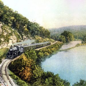
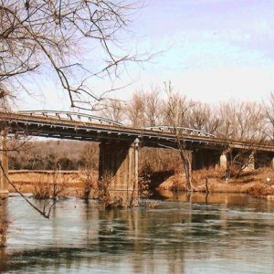
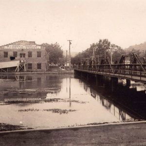
During the Civil War, military units of both sides operated in the Spring River area, and the Skirmish at Martin’s Creek took place on a tributary stream north of the river early in 1864. Major development in the area began when the Kansas City, Springfield and Memphis Railroad was built through the valley from 1881 to 1883.
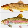
U.S. Highway 63 now provides rapid travel through a great part of the scenic landscape along the river. Hardy (Sharp County) has particularly benefited from this access, becoming one of the most popular areas in north Arkansas. The upper portion of the Spring River is especially popular for swimming and canoe trips. Fishing also draws many visitors to the river. In addition to fish native to the area, the cool water temperature allows the stocking of trout throughout the year. Fly-fishing for rainbow, brown, and cutthroat trout has become a popular sport. Increased recreational use beginning in the 1970s resulted in elevated levels of water pollution, but effective environmental protection has managed to maintain water quality along the river.
Two fish hatcheries are located on the Spring River. The first, a national hatchery, is Mammoth Spring National Fish Hatchery, operated by the U.S. Fish and Wildlife Service and adjacent to Mammoth Spring State Park. The second, a state hatchery, is the Jim Hinkle Spring River State Fish Hatchery, operated by the Arkansas Game and Fish Commission and located two miles downstream from Mammoth Spring.
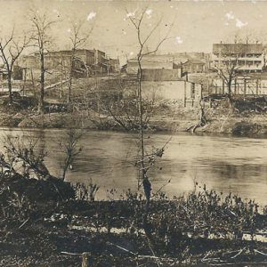
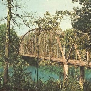
Two small dams are located on the Spring River, both near the origin of the stream at Mammoth Spring. They are too near the headwaters of the river to provide flood control, thus leaving much of the river in a fairly natural state. The upper part contains numerous rocky rapids, several waterfalls, and pools containing drifts and underwater snags, and it should be traveled with care. Floods occur frequently, some of them reaching thirty to forty feet above flood level. Four of these—in 1915, in 1982, 2008, and in 2025—damaged homes and towns and destroyed bridges, and some claimed lives.
For additional information:
Flinders, C. A., and D. D. Magoulick. “Distribution, Habitat Use and Life History of Stream-Dwelling Crayfish in the Spring River Drainage of Arkansas and Missouri with a Focus on the Imperiled Mammoth Spring Crayfish (Orconectes marchandi).” American Midland Naturalist 154 (October 2005): 358–375.
Mohlenbrock, Robert H. “Going with the Flow: An Underground Stream Links Two Scenic Spots.” Natural History 115 (February 2006): 48–50.
“Spring River.” In The Columbian Gazetteer of the World, edited by Saul Cohen. New York: Columbia University Press, 2008.
Charles W. Crawford
Memphis, Tennessee


Comments
No comments on this entry yet.