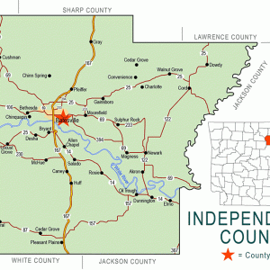
 Independence County Map
 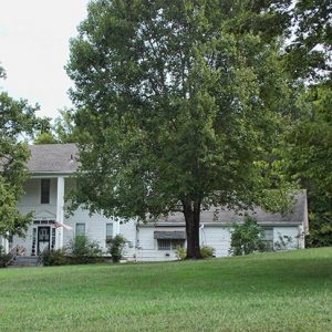 Rutherford House
 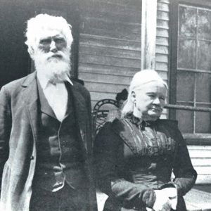 James and Mariah Rutherford
501-918-3025
calsfoundation@cals.org
calsfoundation@cals.org
Rutherford is a historic community that was located in the White River Township. It grew out of the Rutherford Landing on the White River across from the Goodie Creek Valley, along the Jackson Military Road. The landing was originally part of the August Friend-Furnash Spanish grants from 1763 to 1800. The landing was at Russell’s Ferry (a.k.a. Wyatt’s Ferry), today Russell Ferry Road. Wyatt Ferry was licensed in 1817 to John Wyatt, who operated it for about a year, and licensed in November 1818 to John L. Lafferty.
The Jackson Military Road, established in 1831 to parallel the old Southwest Trail, entered Independence County in the Hazel Grove community, continued through Walnut Grove, crossing Dota Creek at Pleasant Hill, traversed the area of Sulphur Rock, and then went to Rutherford Landing, where it crossed the White River. On the south side of the river, the road followed the Goodie Creek valley to the hills and on to Pleasant Plains and White County. Montgomery Spring, a source of fresh water and a place to store food and drink in a spring house, was located on the land (today Gap or Rutherford Road). The Eagle Mountain Golf Course is located on the site.
In 1849, tracking a man who left a $3,000 debt to his uncle, a young James Rutherford traveled to Independence County for his father. The debtor had recently purchased land in the area from Colonel Morgan Magness. James Rutherford took the land in lieu of the money owed. That was the first land owned by the Rutherford family in the county.
Returning home after fighting in the Civil War, Colonel Rutherford was again a gentleman farmer, with his new wife, Mariah Louisa Hynson, whom he had married in 1862, the daughter of prominent landowners of the area.
Colonel Rutherford’s younger brother, Captain George Wherry Rutherford, who came to the White River area with his parents from North Carolina at the age of seventeen in 1850, was a Confederate army captain who enlisted in the Second Arkansas Cavalry in 1862, serving until the war ended in 1865. Following the war, he returned home to be a gentleman farmer. He married Florence Neill of Alder Brook in 1868, daughter of Judge Henry Neill and Dorcus Stark Neill. The captain and Florence had ten children. He died in 1911 and is buried in the Rutherford Cemetery.
A sister to the Rutherford brothers, Mary Ann Rutherford, married David Caldwell Montgomery, who was active in helping found the First Presbyterian Church in Batesville (Independence County) in 1842, one of the oldest churches in the Arkansas Presbytery. David and Mary Ann Montgomery are buried in the Rutherford Family Cemetery on the old Rutherford place on Gap Road. The Rutherford family were significant landowners in both Independence and Jackson counties, and much of the land is still in the family in the twenty-first century.
By 1876, the community around Rutherford Landing had a store, Wilson’s cotton gin, a blacksmith shop, and perhaps a sawmill or stave mill. A short-lived post office was added to the store in 1905, with John A. Gibson appointed first postmaster. The post office closed in 1912.
A one-room school was opened in the early 1900s called the Rutherford School or Mount Gap School; it consolidated with Sulphur Rock in the 1940s. Sulphur Rock later became part of the Batesville School District. Where the school was located became known as Gap Road.
A major problem for Rutherford was flooding—at times devastating. As a result, the population shifted northward. When Newark was founded in 1883 as the railroad came through that town, Rutherford gradually faded away, and the military road fell into disrepair with changing times.
In 2006, the Eastman Chemical plant of Newark was sold to Viceroy Acquisition Corporation. The plant began expanding production of biodiesel and bioethanol. FutureFuel Chemical Company began operating the former Eastman Chemical Company 24 MMgy biodiesel plant. The company owns approximately 2,200 acres of land six miles southeast of Batesville fronting the White River. FutureFuel has a private park—including a golf course for its employees, their families, and guests—in the area where the community of Rutherford once stood.
For additional information:
Biographical and Historical Memoirs of Northeast Arkansas. Chicago: Goodspeed Publishing Co., 1889.
Britton, Nancy. “George W. Rutherford’s Company.” Independence County Chronicle 25 (April–July 1984): 33–35.
Crouch, W. A. “Report from Rutherford’s Company.” Independence County Chronicle 5 (January 1964): 35–36.
Featherstonhaugh, George W. Excursion through the Slave States, From Washington on the Potomac to the Frontier of Mexico; with Sketches of Popular Manners and Geological Notices. New York: Negro Universities Press, 1968.
The History of Presbyterianism in Arkansas 1828–1902. Little Rock: Press of Arkansas Democrat Co., 1902.
McGinnis, A. C. “A History of Independence County, Ark.” Special issue. Independence County Chronicle 17 (April 1976).
Medearis, Mary. Washington, Arkansas: History on the Southwest Trail. Rev. ed. Hope, AR: Etter Printing Company, 1984.
Powell, Admiral Morgan. “Captain Rutherford’s Company, CSA.” Independence County Chronicle 5 (January 1964)” 17–18.
Rutherford, Colonel James. “A Glimpse of Batesville in 1849.” Independence County Chronicle 1 (April 1960): 29–31.
Rutherford, Mary. “The First Presbyterian Church.” Independence County Chronicle 1 (April 1960): 3–15.
———. “Walter B. Rutherford and His Family.” Independence County Chronicle 5 (April 1964): 19–20.
Kenneth Rorie
Van Buren, Arkansas


Comments
No comments on this entry yet.