501-918-3025
calsfoundation@cals.org
calsfoundation@cals.org
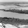
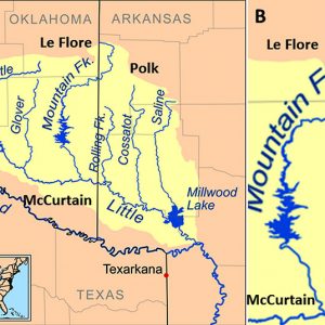
The Mountain Fork River is a 158 km (98 mi.) tributary of the Little River in far west-central western Arkansas and southeastern Oklahoma. There are two major portions of the river: the upper Mountain Fork and the lower Mountain Fork. On the Arkansas side, the Mountain Fork belongs within the Ouachita Mountains natural division, Fourche Mountains subdivision, and just within the Red River system of the state. The headwaters of the upper course begin in the Ouachita Mountains (Weehunt Mountain) of Polk County, Arkansas, at the town of Mountain Fork on Arkansas Highway 8 where it then flows southward under Highway 246 (at a low water bridge) for about 16 km (9.8 mi.). Farther south, it then takes a right turn (west) and flows past the Oklahoma border, then southwestward under Highway 4 to Smithville, Oklahoma. The river then continues due south through the Ouachita National Forest past U.S. Highway 259, where it goes through the “narrows” just above the lake and ends at the dam (built in 1969) to form Broken Bow Lake in McCurtain County, Oklahoma. The lower part of the Mountain Fork River begins at the spillway in Beaver’s Bend State Park and flows to a low-water dam just inside the park boundaries. It then travels about 13 km (8.2 mi.) past Presbyterian Falls and under the U.S. Highway 70 bridge just east of Broken Bow, Oklahoma. The remainder of its course ends farther southeast about 10.2 km (6.4 mi.) as it flows into the Little River near the western boundary of the Little River National Wildlife Refuge.
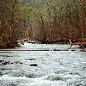
The Mountain Fork River in Oklahoma is a designated trout stream for about 19 km (12 mi.) and supports both stocked rainbow and brown trout. The Oklahoma Department of Wildlife and Fisheries provides stock trout to make it a year-round fishery. In 2008, a 7.8 kg (17 lb. 4 oz.) brown trout (Salmo trutta) was caught by an angler in the Mountain Fork. In addition to fisheries, the upper Mountain Fork River is a popular seasonal stream that offers about 51 km (32 mi.) of canoeing and kayaking from near Hatfield (Polk County) to Broken Bow Lake. This portion of the river provides both Class I and II whitewater rapids.
The Mountain Fork is a fairly wide river with occasional ledges and long pools. It flows down a shallow gradient of approximately 2.4 to 3.0 m/min. (8 to 10 ft./min.) in a riverbed consisting of rock ledges that form small drops and long pools of flatwater. A popular activity among canoeists and kayakers is to run about 14 km (9 mi.) between U.S. Highway 259 at Smithville through what is termed “the narrows,” where larger drops are situated near the top of Broken Bow Lake. Below the lake, it becomes the lower Mountain Fork as it flows out of the dam below the lake at the power plant. The flow of the river slows considerably for about 8 km (5 mi.) between the power plant and the reregulation dam, where the whitewater section of the lower Mountain Fork begins.
Below Broken Bow Lake and dam, the 30 km (19 mi.) of the consistently flowing lower Mountain Fork has been described as the best whitewater stream in Oklahoma. Class I and II rapids are found in the upper part of this section, and paddlers must navigate waterfalls with a 1.2 m (4 ft.) drop.
Concerning noteworthy fish biota of the river, there are historical records of the Kiamichi shiner (Notropis ortenburgeri) from a single locality in the upper Mountain Fork River of Arkansas and also from Lick Creek, a tributary of the Mountain Fork River in Oklahoma. In addition, the peppered shiner (Notropis perpallidus) has been collected in both the upper and lower portions of the river. Interestingly, the type locality for the Ouachita Mountain shiner (Lythrurus snelsoni) is the Mountain Fork River at Arkansas Highway 246 bridge, 4.8 km (2.9 mi.) west of Hatfield. According to the Arkansas Game and Fish Commission, all three species (family Leucisidae) are on the list of the Species of Greatest Conservation Need and protected in the state.
For additional information:
Arkansas Endangered, Regulated, and Species of Greatest Conservation Need. Arkansas Game and Fish Commission, Little Rock, 2018.
Finnell, J. C., Robert M. Jenkins, and G. E. Hall. The Fishery Resources of the Little River System, McCurtain County, Oklahoma. Norman: Oklahoma Fish Resources Laboratory Report Number 55, 1956.
“Lower Mountain Fork River Trout Regulations.” Beavers Bend State Park. http://www.beaversbend.com/fishing.html (accessed September 3, 2020).
Miller, Rudolph J., and Henry W. Robison. Fishes of Oklahoma. Norman: University of Oklahoma Press, 2004.
“Mountain Fork.” American Whitewater. https://www.americanwhitewater.org/content/River/detail/id/2575/ (accessed September 3, 2020).
Mountain Fork River. Southwest Paddler. http://southwestpaddler.com/docs/littleok9.html (accessed September 3, 2020).
Robison, Henry W. “Status Survey of the Peppered Shiner, Notropis perpallidus Hubbs and Black, in Arkansas and Oklahoma.” Journal of the Arkansas Academy of Science 60: 101‒107. Online at https://scholarworks.uark.edu/jaas/vol60/iss1/16/ (accessed September 3, 2020).
Robison, Henry W., and Thomas M. Buchanan. Fishes of Arkansas. 2nd ed. Fayetteville: University of Arkansas Press, 2020.
Chris T. McAllister
Eastern Oklahoma State College


Comments
No comments on this entry yet.