
501-918-3025
calsfoundation@cals.org
calsfoundation@cals.org
| Latitude and Longitude: | 34°10’09″N 094°18’59″W |
|---|---|
| Elevation: | 758 feet |
| Area: | .92 square miles (2020 Census) |
| Population: | 157 (2020 Census) |
| Incorporation Date: | October 1, 1902 |
Historical Population as per the U.S. Census:
|
1810 |
1820 |
1830 |
1840 |
1850 |
1860 |
1870 |
1880 |
1890 |
1900 |
|
|---|---|---|---|---|---|---|---|---|---|---|
|
– |
– |
– |
– |
– |
– |
– |
– |
– |
– |
|
|
1910 |
1920 |
1930 |
1940 |
1950 |
1960 |
1970 |
1980 |
1990 |
2000 |
|
|
– |
– |
– |
– |
– |
– |
– |
– |
– |
– |
|
|
2010 |
2020 |
|
|
|
|
|
|
|
|
|
|
160 |
157 |
|
|
|
|
|
|
|
|
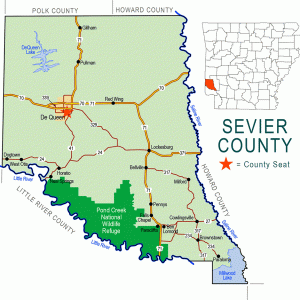
Gillham is a town in northern Sevier County. Originally founded as Silver City, it was relocated and renamed with the arrival of the railroad in the area. The main highway through Gillham is the concurrent route of U.S. Highways 59 and 71.
A prosperous farmer named John Bellah claimed land in northern Sevier County in 1850. Sometime in the following decade, Bellah found a sample of gray metal on his land that he believed to be silver. He sank a shaft of ten to twenty feet but found no further samples. During the 1860s, the Confederate government also sought silver on Bellah’s property without success. Following the Civil War, investors drawn into Arkansas during Reconstruction further investigated Bellah’s land, and a mining community was created that was named Silver Hill. A post office was established in 1874, and the community acquired a store that is said to have earned about $10,000 a year during the mining boom.
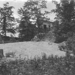
The material Bellah had found proved to be not silver but antimony. This metal, useful in alloys with lead or with tin, was attractive to miners who worked the area from 1873 to 1924, with peak production occurring during World War I. Meanwhile, both because of the mines and because of the agricultural production of the area, the Kansas City Southern Railroad built a line through the region that eventually extended to Texarkana (Miller County). The line missed Silver Hill by more than a mile, and the community, with its post office, relocated to the east to be near the railroad. At that time, it also was renamed Gillham to honor Robert Gillham, chief engineer of the railroad.
By the time Gillham was incorporated in 1902, it had a large feed store, two sawmills, a hotel, a school, a newspaper called The Miner, and about 400 residents. Local crops brought to town and shipped by rail included strawberries, turnips, cucumbers, green beans, squash, grapes, cantaloupes, radishes, and blackberries. Timber was also an important industry for the area. A bank was chartered in 1905, and, by 1909, Gillham had a cotton gin, a grist mill, a second hotel, a restaurant, a Baptist church, a Methodist church, a Masonic lodge, and a public school that taught grades one through ten.
The town remained economically strong through the 1920s, even after a fire in 1928 destroyed the telephone exchange, four businesses, and three residences, also damaging the bank and the Goff and Gamble Merchandise Store. Even with the tightening of the national economy during the Depression, fruit and vegetable production continued to provide jobs and, in the words of local historian Betty McCommas, “the people survived though money was scarce.”
Ironically, World War II caused more harm to the local economy than had the Depression. In the summer of 1942, one packing house shipped 40,000 bushels of cucumbers, but as more men entered the armed forces, workers were scarce, and farm production plummeted. By the time the war ended, the Gillham area had lost out to other farming centers where mechanical assistance made farmers less dependent upon laborers. The population decline that began during the Depression accelerated after the war.
In 1963, construction began on Gillham Dam, located on the Cossatot River six miles north of Gillham. Although a court case filed in 1970 sought to cease construction of the dam to preserve the environment of the river and adjacent lands, the case only delayed construction for about a year. The lake and dam were completed in 1975. Gillham Lake has five boat ramps and is popular for bass fishing. On its shores are three campgrounds, one picnic shelter, and one designated swimming area. There is also a walking trail along one part of the lake. The population of Gillham increased during the years of dam and lake construction, only to shrink again after 1980.
The poultry industry provides jobs to many residents of Sevier County, but there are no poultry plants in Gillham. The two largest employers in the town are Tri Lakes Services, a freight shipping and trucking business, and the DeQueen Mena Educational Cooperative, which serves schools in five counties of southwestern Arkansas. Gillham also has churches, as well as a hunting club, a convenience store, a hair salon, a branch library, and a volunteer fire department. The U.S. Army Corps of Engineers maintains an office in Gillham.
In 2010, the U.S. Census counted 160 people living in Gillham, of whom 132 were white, with no African Americans. Thirty-four Gillham residents were identified as Hispanic. The population remained much the same the following census.
The National Register of Historic Places lists two structures in Gillham. One is the Goff and Gamble Merchandise Store, built around 1910, and the other is the Gillham jail, a single-cell cement jail built around 1914.
For additional information:
McCommas, Betty. The History of Sevier County and Her People. Dallas, TX: Taylor Publishing Company, 1980.
Steven Teske
Butler Center for Arkansas Studies


Additional information on Herd/Herd’s Switch (from Benton County Schools That Were, volume 4, by Billie Jines): “Long gone, too, is the Frisco Railroad siding that led to a spot across Highway 62 once known as Herd’s Switch. That tiny village sent its boys and girls to Bayless School a mile away. Thus, Bayless School was referred to as Herd’s Switch School. There still are Herds at the old Herd’s Switch location and elsewhere in the vicinity, but most have long since settled on the Hurd spelling of the name. Richard Hurd [still living as of June 2016] remembered the railroad siding when this story was being researched. He said that it was not much more than a block long. He said he thought it was taken up about the time of World War II. Richard recalled, too, a sign put up by the railroad that called the spot OSBORNE. No one but the railroad people used that name.” Herd’s Switch was located on what is now OLD HIGHWAY ROAD. This is on the southeast side of the railroad tracks while the current Highway 62 is on the northwest side of the tracks.