501-918-3025
calsfoundation@cals.org
calsfoundation@cals.org
| Latitude and Longitude: | 35°51’19″N 090°02’30″W |
|---|---|
| Elevation: | 243 feet |
| Area: | 0.92 square miles (2020 Census) |
| Population: | 194 (2020 Census) |
| Incorporation Date: | August 12, 1905 |
Historical Population as per the U.S. Census:
|
1810 |
1820 |
1830 |
1840 |
1850 |
1860 |
1870 |
1880 |
1890 |
1900 |
|
|---|---|---|---|---|---|---|---|---|---|---|
|
– |
– |
– |
– |
– |
– |
– |
– |
– |
– |
|
|
1910 |
1920 |
1930 |
1940 |
1950 |
1960 |
1970 |
1980 |
1990 |
2000 |
|
|
162 |
233 |
267 |
323 |
384 |
383 |
358 |
310 |
258 |
251 |
|
|
2010 |
2020 |
|
|
|
|
|
|
|
|
|
|
223 |
194 |
|
|
|
|
|
|
|
|
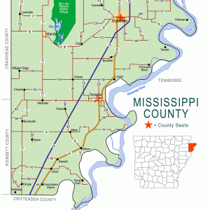
Dell is a town in Mississippi County, a few miles southwest of Blytheville (Mississippi County). State Highways 18 and 181 pass through Dell.
When Arkansas became a state, the region around Dell was swampy and forested. Pemiscot Bayou runs into the Little River near Dell, so travelers passed through the area by flatboat and by steamboat. The first landowner in what would become Dell was Thomas J. Blackmore, who acquired about 160 acres of swampland in 1855 through the Swamp Land Act of 1850. Blackmore may not have even visited the land before he sold it, as the land went through several absentee owners until it was purchased by W. B. Sizemore in 1878. During the Civil War, a skirmish was fought near Pemiscot Bayou on April 6, 1864; a Federal force seeking guerrilla fighters was surprised by those fighters, who crept into their camp under the cover of darkness and rain. Three Federal soldiers were killed, and seven were wounded.
J. D. Widner bought the land from Sizemore’s son around 1896. The community of Dell began to develop by the bayou. J. B. Richardson owned a loading dock in Dell and opened a store there; a post office opened in the store in 1897. A school was established in 1896, with the schoolhouse also used as a church. The Jonesboro, Lake City, and Eastern Railroad began building tracks into the forest in 1902, constructing a bridge across Big Lake to the west of Dell. A town was laid out next to the railroad line. At first, it was known as Rozell, named for the landowner who provided right-of-way to the railroad. Because another nearby town was named Rozelle, and because Richardson and most of the other residents of Dell had moved to the new community, it was given the name Dell. It incorporated in 1905.
During the timber era of Mississippi County, Dell was a booming community. It had hotels, boarding houses, saloons, and restaurants. Most of the homes and other buildings were built of logs, as timber was plentiful in the area. As the land was cleared, it was converted to farmland—mostly for cotton at first, but later soybeans, rice, milo, and corn were also grown. Dell had three cotton gins, some of which operated twenty-four hours a day during harvest time. The Dell Gin Company, established in 1926, became one of the most prominent businesses in Mississippi County. For some years, a Methodist congregation gathered in Dell.
The Flood of 1927 was particularly hard on Dell. Some levees failed, while others held, trapping floodwater in land that was meant to be protected. The town of Dell was surrounded by water, and citizens begged for permission to break open the restraining levees. Much of the railroad (which by this time was part of the St. Louis–San Francisco Railway) was swept away. During the flood, the American Red Cross assisted 1,091 refugees on the high land where Dell had been built.
Eventually, the flood abated, and the rich farmland again produced prodigiously. Wealthy citizens were able to support the local school throughout the Depression so that it lost money during only one year of that time period. Three small school districts were consolidated into the Dell School District. A high school was established in Dell in 1939. Improvement of highways and consolidation of schools in the twentieth century began to threaten the survival of isolated towns such as Dell. Earl Magers invested in land around the town, building and selling houses; he set aside one section of the town for African-American families and businesses. The Dell Gin Company closed in 1975, followed by the Farmer’s Gin Company of Dell in 1985.
In 2001, leaders of the town rejoiced that TECO Power Systems of Tampa, Florida, was beginning to build a large power plant in Dell. At first, hopes were high that the plant would be operating in 2003, but construction was still not complete by 2005. TECO sold the unfinished project to Associated Electric Cooperative of Missouri, and the plant was finally dedicated in 2008.
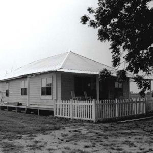
Dell remains home to Home Oil Company, as well as a handful of small businesses. Cotton and soybeans continue to support the local economy. There are two Baptist churches in Dell. Widner-Magers Farm, north of Dell, was added to the National Register of Historic Places on January 29, 2007.
For additional information:
Drew, Lee A. “The J.L.C. & E.R.R. and the Opening of the ‘Sunk Lands’ in Northeast Arkansas.” Arkansas Historical Quarterly 27 (Spring 1968): 22–39.
Edrington, Mabel F. History of Mississippi County, Arkansas. Ocala, FL: Ocala Star-Banner, 1962.
Town of Dell Arkansas. https://www.townofdell.com/ (accessed February 8, 2026).
Whayne, Jeannie. Delta Empire: Lee Wilson and the Transformation of Agriculture in the New South. Baton Rouge: Louisiana State University Press, 2011.
“Widner-Magers Farm Historic District.” National Register of Historic Places nomination form. On file at Arkansas Historic Preservation Program, Little Rock, Arkansas. Online at https://www.arkansasheritage.com/docs/default-source/national-registry/ms0301-pdf.pdf?sfvrsn=53aed257_0 (accessed February 8, 2026).
Steven Teske
Butler Center for Arkansas Studies


Comments
No comments on this entry yet.