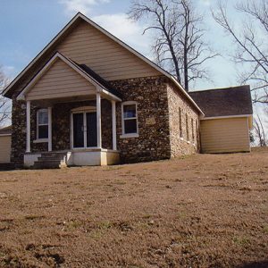
 Columbia Jarrett Baptist Church
 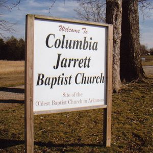 Jarrett Baptist Church Sign
 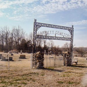 Jarrett Cemetery
 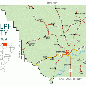 Randolph County Map
501-918-3025
calsfoundation@cals.org
calsfoundation@cals.org
The town of Columbia, cited by many as the second-oldest settlement in northeast Arkansas, was located on the banks of the Fourche Creek in present-day Randolph County. Originally known as Fourche de Thomas, it was established by some of the area’s earliest settlers in the early 1800s and is documented as the site of the first Baptist church in Arkansas.
By 1811, a road later known as the Southwest Trail or Military Road, originating in Missouri and extending into the area, crossed the Fourche Creek near a small settlement. This roadway contributed to a steady stream of additional settlers, including the Fletcher, Lindsey, Jarrett, and Hoover families. Some believe that French trappers, who referred to the stream as Fourche de Maux or du Mas, briefly lived in the area prior to the American settlers. In 1815, the Missouri Territory county of Lawrence was created, and it included the settlement on the Fourche Creek, which was one of only four in the area. That same year, county court records refer to the settlement as Columbia. On January 28, 1815, William Russell, whose house was less than two miles from Columbia, was appointed as the first justice of the peace by the Missouri territorial governor. Shortly afterward, a session of the first county court was held in his residence. In 1820, area resident Edward McDonald was chosen as the first Lawrence County representative for what had become Arkansas Territory.
In 1818, the first Baptist church in Arkansas was founded at Columbia. Included in the original twelve members were James Edwards, Jesse James, Benjamin Clark, and Richard Brazil. Known as the Salem Baptist Church, it became a part of the Black River Association. The congregation disappeared from the record about 1835, around the same time that the town of Pocahontas was chosen as the seat for the newly established Randolph County. The church, which reorganized as the Columbia Jarrett Baptist Church in 1937, continues to hold services in the twenty-first century. In 1954, the Arkansas Baptist State Convention placed a marker at the site. A second marker was placed in 1993.
Explorer and ethnologist Henry Schoolcraft traveled through the lands bordering what he called Fourche a’ Thomas in 1819. He described the surrounding countryside as “excellent lands…very rich” and noted that there were several settlements north of the river and “habitations of man occasionally interspersed among the woods.”
During its early days, the community was a political and economic rival to Davidsonville (Randolph County), some twenty-three miles to the south. On July 4, 1821, an elaborate celebration of American independence was observed. The celebration included the installment of a liberty pole and a public reading of the Declaration of Independence. Also on May 19, 1821, the first marriage in Lawrence County was performed in the community.
While mail had been carried along the Southwest Trail for many years, a post office was not established until 1829. By the mid-1830s, the name had been changed to Fourche Toma (or Fourche Dumas), and the office was closed by 1866.
A major development in the future of the community came with the creation of Randolph County on October 29, 1835. Columbia was in competition with Bettis Bluff (now Pocahontas), located eight miles south, for the seat of government for the new county. Ransom Bettis and his son-in-law, future Arkansas governor Thomas Drew, threw a big party at Bettis Bluff on the day set aside for the election to decide the county seat. A majority of citizens gathered at the settlement that bore Bettis’s name and selected it as the county seat of government.
After the county seat election, Columbia began a decline as new arrivals were attracted to Pocahontas on the Black River. Soon, the Baptist church ceased services. The community briefly played a small part in Indian Removal when one of the four routes of the Trail of Tears, the Benge Route, passed through the county. A Native American group following this route camped at Foster Ford near the community on December 9, 1838.
With the exception of a cemetery, little remained of the old settlement within a few short years. Even the name changed to Lindseyville and then Jarrett. As of 2011, the meeting house of the reorganized Baptist church, the Columbia Jarrett Baptist Church, is all that stands near the site of the community.
For additional information:
Dalton, Lawrence. “Fourche Dumas Creek and the Settlement of Fourche de Thomas.” Arkansas Historical Quarterly 4 (Winter 1945): 353–362.
———. The History of Randolph County. Little Rock: Democrat Printing and Lithographing Company, 1946.
Lawrence County, Arkansas: 1815–2001. Paducah, KY: Turner Publishing Company, 2001.
McLeod, W. E. “Early Baptist Movements in Northeast Arkansas.” Arkansas Historical Quarterly 5 (Summer 1946): 154–168.
Randolph County Arkansas: Histories and Families. Paducah, KY: Turner Publishing Co., 2001.
Mike Polston
CALS Encyclopedia of Arkansas


Comments
No comments on this entry yet.