 Black Fork Cemetery
 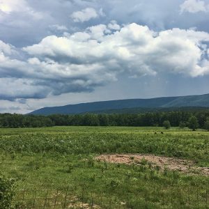 Black Fork Mountain
 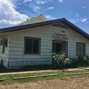 Friendship Baptist Church
 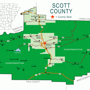 Scott County Map
501-918-3025
calsfoundation@cals.org
calsfoundation@cals.org
Black Fork is an unincorporated community located in southwestern Scott County, just north of Black Fork Mountain. Black Fork was named after a creek—supposedly with dark, murky water—that flows through the area. Black Fork Creek is a distributary of the Fourche La Fave River and a tributary of the Poteau River. The agriculture and timber industries have traditionally been important in Black Fork.
Archaeological findings have provided evidence of early inhabitants dating to the Archaic, Woodland, and Mississippian periods. Further archaeological evidence has indicated that people of the Caddo tribe inhabited the area.
During the late seventeenth and early eighteenth centuries, French hunters and tradesmen traveled west from the Arkansas Post exploring portions of western Arkansas. Several rivers that flow through Scott County were likely named by these French explorers, including the Petit Jean, Poteau, and Fourche La Fave rivers. It is probable that the explorers traveled through the area near present-day Black Fork.
In 1825, the Black Fork area was surveyed for a road being built from Fort Smith (Sebastian County) to Fort Towson across Winding Stair Mountain in eastern Oklahoma. During the 1830s, settlers began arriving in the Black Fork area. Some of the earliest citizens in the community were David Jones, Milton Larimore, Jasper Foster, Newton Foster, and George Washington Wiles.
In the early 1850s, Chief J. F. McCurtain contended that Arkansas contained a portion of the Choctaw Nation as designated by the U.S. Congress. A survey was conducted in 1855, and it was found that approximately 137,500 acres of Arkansas belonged to the Choctaw Nation. The Black Fork community was included in the surveyed land. Congress passed an act in 1875 that designated the original survey in 1825 as the boundary between the Choctaw Nation and Arkansas. The Choctaw Nation is said to have received fifty cents an acre for the land.
No reported Civil War military activity took place around Black Fork. The oldest known grave in the Black Fork Cemetery dates to 1873; however, the cemetery was likely established prior to then.
During the 1880s, desire for petroleum was growing in Arkansas. Black Fork was one of the few communities in Scott County where an oil well was established, even though there was no oil found.
There were thirty-one families living in Black Fork according to the 1870 census. During the early 1870s, mail was directed to the Waldron Post Office for citizens in Black Fork. The Black Fork Post Office was established in 1877, with John W. Walker as the first postmaster.
The 1880 census placed sixty-one families within the Black Fork community. Many of these residents worked in agriculture. In 1880, Black Fork had a general store, school, doctor’s office, and church.
In May 1882, the Scott County Courthouse burned, destroying all records that defined the boundaries of the various school districts that had been established throughout the county. Several months later, in August, the county court re-established the boundaries of the fifty-six school districts active in the county, including Black Fork School District (Number 27).
The Black Fork area continued to grow in the early twentieth century. There were 128 families living in the area in 1910. During this time, “tie hackers” cut timber on Black Fork Mountain to make railroad ties for the expanding railroad. These were then sold to the Arkansas Western and Rock Island Railroad for approximately twenty-three cents each. The sawmill at Blansett (Scott County), east of Black Fork, became a center for timber activity in the area due to the need for railroad ties. After World War I, the railroad industry continued to grow; however, the population of Black Fork began to decline.
L. O. Day was one of the general merchants in Black Fork during this time and also operated a small truck dealership. The roads in Black Fork were still unpaved, and the need for larger vehicles became necessary when the roads would flood or become muddy.
The 1930 census recorded only sixty-eight families living in the community. After World War II, Black Fork’s population continued to fall due to the decline of the timber industry in the area and the consolidation of schools. The Black Fork School District was consolidated with Acorn (Polk County) sometime between 1949 and 1953.
In 1981, the Black Fork Post Office was discontinued. A portion of Black Fork Mountain was designated as a National Wilderness Area in 1984. There are still no paved roads anywhere within the isolated community in the twenty-first century. Agriculture continues to be important in the area, though the farms are much larger and less diverse than in the past. The only religious institution remaining in Black Fork is the Friendship Baptist Church, which was previously the Black Fork Baptist Church. Hunting and fishing are popular recreational activities among residents in the area, which is surrounded by the Ouachita National Forest. Black Fork is also serviced by the Black Fork Volunteer Fire Department.
For additional information:
Biographical and Historical Memoirs of Western Arkansas. Chicago: Goodspeed Publishing Company, 1891.
Cate, Michael. History of Scott County, Arkansas. Dallas, TX: Curtis Media Corporation, 1991.
Goodner, Norman. A History of Scott County, Arkansas. Siloam Springs, AR: Bar D Press, 1941.
McCutcheon, Henry Grady. History of Scott County, Arkansas. Little Rock: H. G. Pugh and Company, 1922.
Ty Richardson
Richardson Preservation Consulting


Comments
No comments on this entry yet.