calsfoundation@cals.org
Reyno (Randolph County)
| Latitude and Longitude: | 36°21’46″N 090°45’13″W |
| Elevation: | 285 feet |
| Area: | 1.016 square miles (2010 Census) |
| Population: | 456 (2010 Census) |
| Incorporation Date: | October 18, 1886 |
Historical Population as per the U.S. Census:
|
1810 |
1820 |
1830 |
1840 |
1850 |
1860 |
1870 |
1880 |
1890 |
1900 |
|
– |
– |
– |
– |
– |
– |
– |
– |
– |
138 |
|
1910 |
1920 |
1930 |
1940 |
1950 |
1960 |
1970 |
1980 |
1990 |
2000 |
|
– |
392 |
314 |
346 |
292 |
348 |
356 |
521 |
467 |
484 |
|
2010 |
|
|
|
|
|
|
|
|
|
|
456 |
|
|
|
|
|
|
|
|
|
The city of Reyno is located in Randolph County on U.S. Highway 67, some sections of which are listed on the National Register of Historic Places. About halfway between Pocahontas (Randolph County) and Corning (Clay County), Reyno is situated near the Current River. The city moved about two miles early in the twentieth century to take advantage of the newly built rail line through the area.
Later historians have asserted that Reyno was once called Cherokee Bay, but that it came to be known as Reyno, a shortening of the name of one of the first settlers at that location, Dennis W. Reynolds, who built a home and a hotel at that site in 1857. However, the Goodspeed history for northeastern Arkansas notes that Reynolds first worked at a mercantile in Cherokee Bay before clearing the townsite later known as Reyno, thus indicating that these were two separate communities. Reyno appears to have been two miles east of Cherokee Bay, although the communities had close ties.
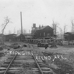
Several other families joined Reynolds in the area, including Stephen McCrary, who built a cotton gin and a sawmill. A post office was established at Cherokee Bay in 1857, and several stores were opened, making Cherokee Bay an active trading center. A Masonic lodge, a saloon, and a horse-racing track were also built.
According to local historians, in September 1863, a skirmish took place north of Cherokee Bay, in which a group of Confederate soldiers attacked a Federal unit passing through the area. A similar skirmish also took place on May 8, 1864. Area communities were not damaged during the war and continued to thrive afterward, benefiting from river traffic and from a road that carried a daily stage from Corning bearing mail and light freight.
Reyno was officially platted and incorporated in 1886, and the post office was renamed Reyno that same year. A Baptist congregation took possession of the horse-racing track and built a church they called Round Track Baptist Church. A ferry crossing the Current River near Reyno began operating in 1902 and continued to operate until the 1970s, when a bridge was built across the river.
In 1901, the St. Louis–San Francisco Railway (commonly called the Frisco) completed a line from Cape Girardeau, Missouri, to Hoxie (Lawrence County). The railroad passed through Corning and Pocahontas but missed Reyno by two miles. Community leaders relocated the city, purchasing land from farmer D. Hopson that at one time had been acquired by French land developer Francis Surget. The new city was for a brief time called Esselwood, but since most of its citizens had come from Reyno, they elected to keep the same name. Old Reyno became a ghost town, and new Reyno was formally incorporated in 1908. The new Masonic lodge devoted its first floor to a school for the city. Businesses and churches were also relocated to the new site. Many houses were physically moved to the new location. In the early twentieth century, the city had a successful baseball team, the Cherokee Indians, which played teams from Paragould (Greene County), Jonesboro (Craighead County), Poplar Bluff, Missouri, and other nearby cities and towns, reportedly losing very few games.
By 1946, Reyno was a prosperous community with three churches, four stores, and several other businesses. That year, the school district was consolidated with that of Biggers (Randolph County) to form the Biggers-Reyno School District. Author Gilbert Morris taught English in the school from 1958 to 1961. By 1992, the city had four churches (two Baptist, one Methodist, and one Church of Christ), a bank, two grocery stores, two gas stations, a coffee shop, a car repair shop, and other businesses. The Biggers-Reyno School District was consolidated into the Corning School District in 2004, leading to the closing of the Biggers-Reyno High School in 2006. As of 2013, Reyno had at least two churches, a bakery, an automobile business, and a flooring business.
For additional information:
Cook, Regina. History of Randolph County, Arkansas. Dallas, TX: Curtis Media Corporation, 1992.
Dalton, Lawrence. History of Randolph County, Arkansas. N.p.: 1946.
Greenberg, Brooke. “The Creation of Cherokee Bay.” Arkansas Democrat-Gazette, July 21, 2024, p. 3H. Online at https://www.arkansasonline.com/news/2024/jul/21/the-creation-of-cherokee-bay/ (accessed July 22, 2024).
Randolph County, Arkansas: A Pictorial History. Morley, MO: Acclaim Press, 2006.
Randolph County Arkansas History and Families. Paducah, KY: Turner Publishing Company, 2001.
Steven Teske
Butler Center for Arkansas Studies
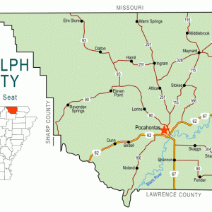
 Randolph County Map
  Reyno Cotton Gins


I grew up in Reyno and left there in 1944. It already had three churches then. Dennis Wells Reynolds and his wife Mattie (according to his diary) enumerated children for the first school. They rode horseback to do this. I was told by an old timer that Dennis would go to the school and ask if any needed books or pencils, before the government supplied these things. He happens to be my great-grandfather. My uncle was a barber and next door to him was a liquor store owned by Mr. Vincent. His daughter owned a dance hall next to him. We had a shoe repair shop owned by Mr. Franklin. We also had a theater, next to the bank, I believe. Before that, those who wanted to see a western movie could sit on the ground at the side of the building where one was shown on Sat. night. The “big deal” was to go to town on Sat. night and walk the street to see all who had come to town. Not very many cars were cruising back then.